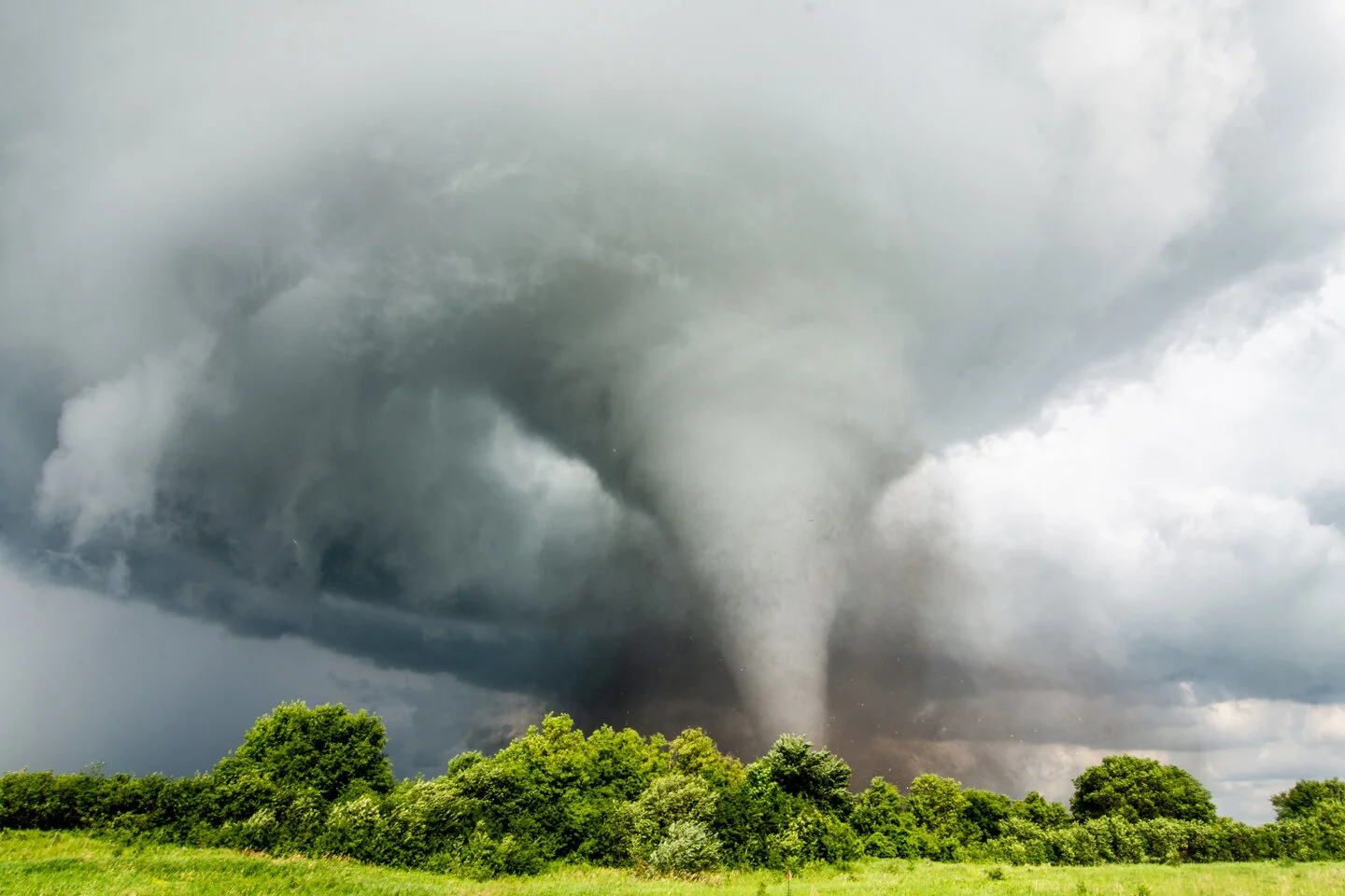
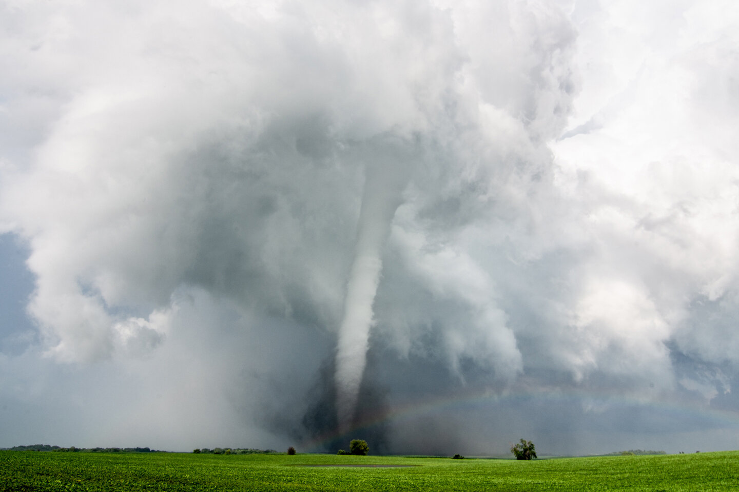
JULY 18, 2020 MINNESOTA: TORNADO WARNED STORM THROUGH NORTHERN TWIN CITIES METRO


1.jpg

Met up with Roger Hill, Rusty Nelson and the Silver Lining Tours crew in Willmar, MN as we waited for storms to initiate. Good to see them and catch up!

DSC_4733.jpg

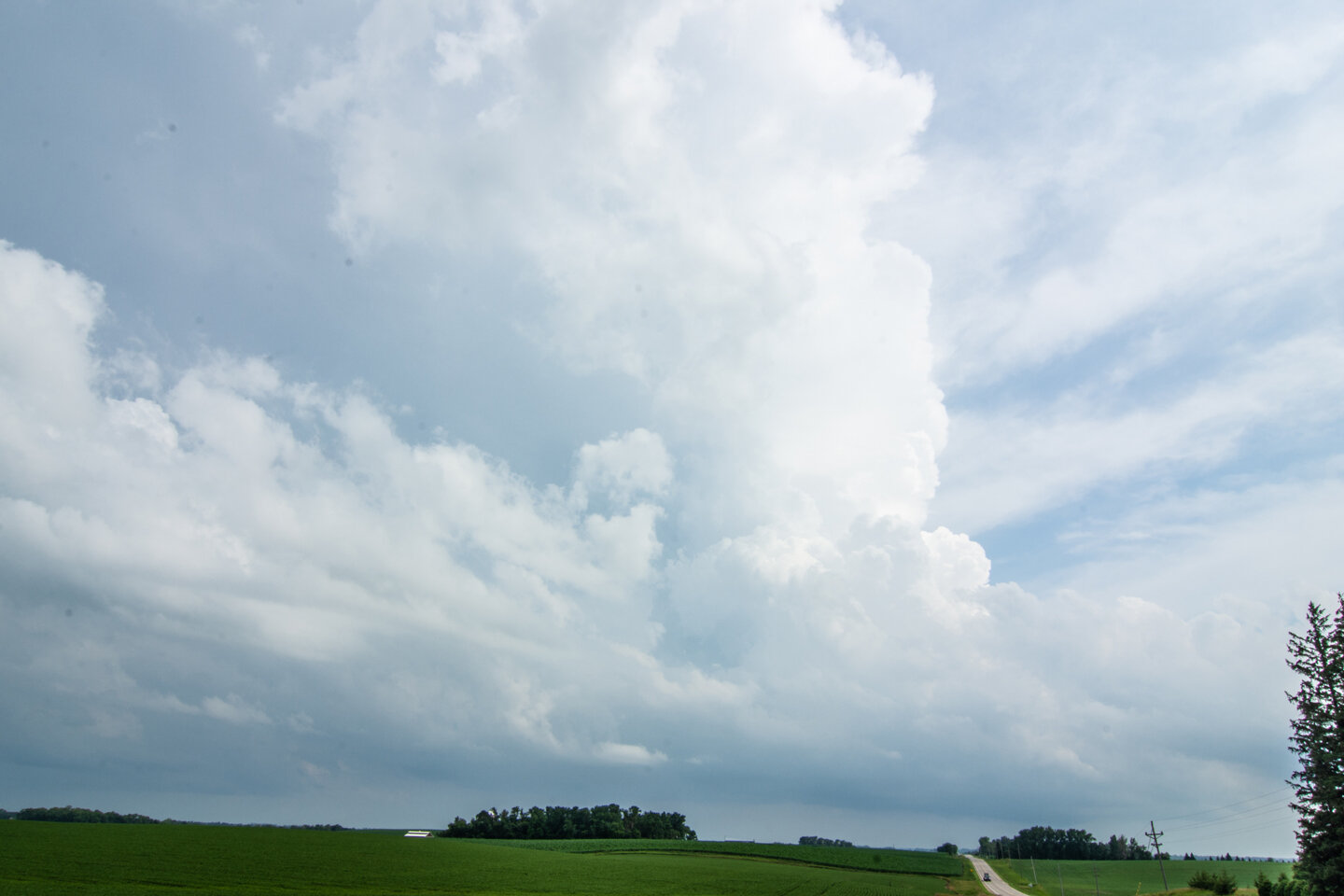
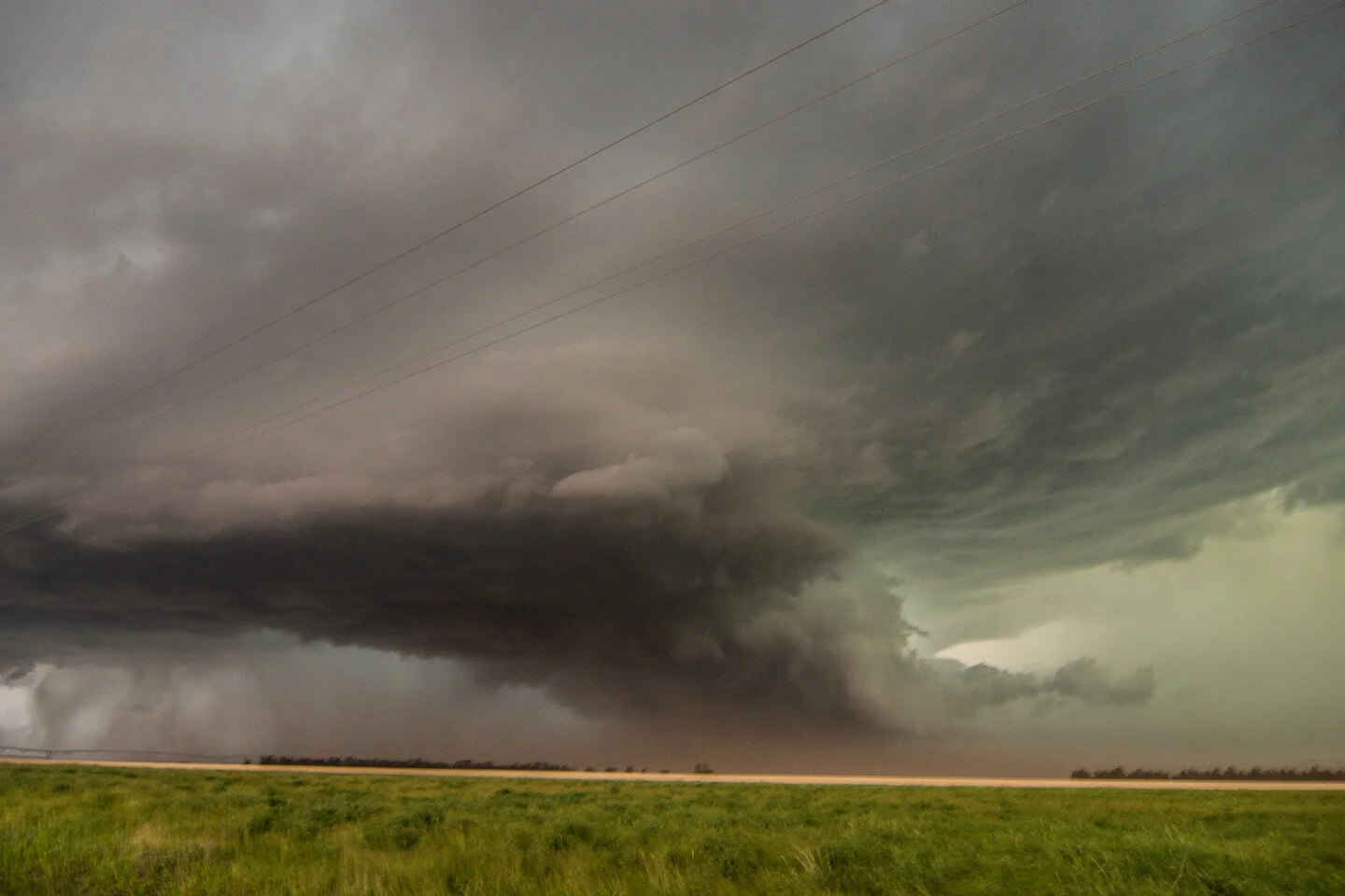
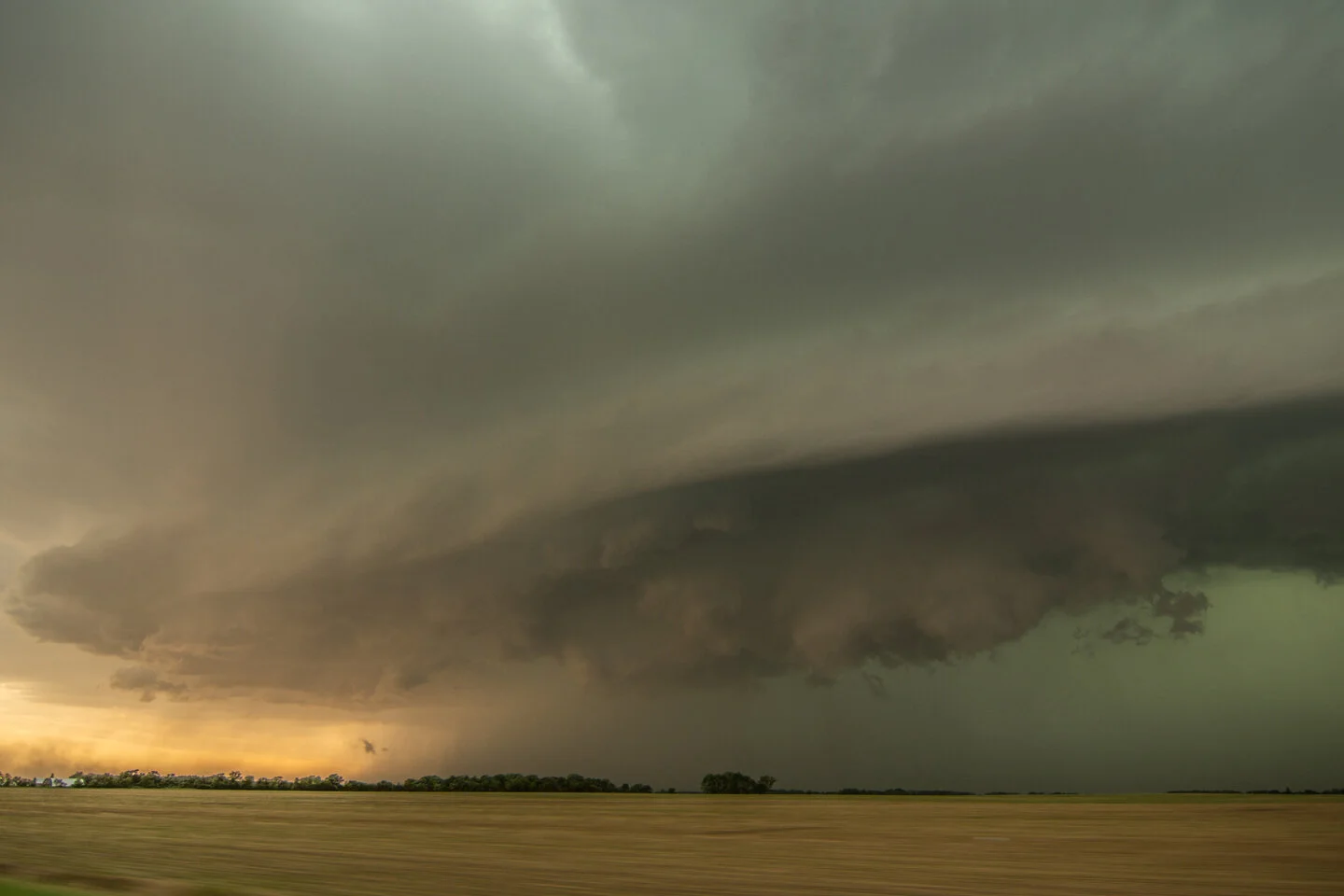
Storm developed further east than we were expecting. Had to blast back east towards the Twin Cities. This is the initial storm updraft looking southeast from Annandale, MN towards Brooklyn Park.

DSC_4749.jpg

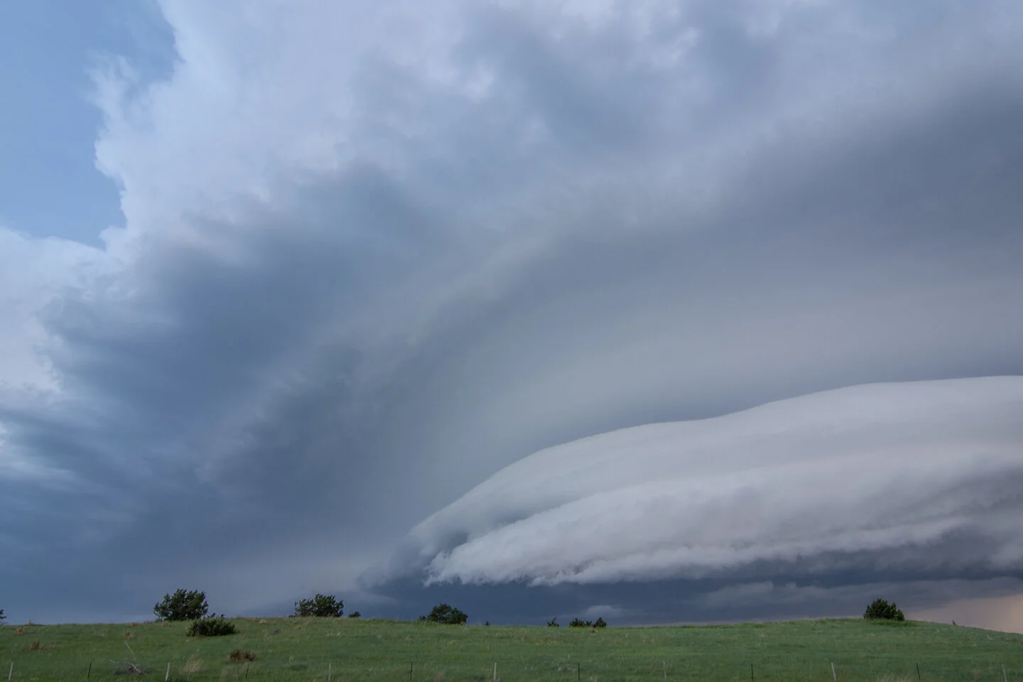
A nervous moment as we watched this wall cloud mature, driving on Hwy 14/Main Street from Coon Rapids into Blaine. Inflow right to left into the wall cloud and condensation/rotation with that small dark feature on the right side underneath the wall cloud as it was trying to produce a funnel. Glad it didn't drop a tornado in the northern suburbs!

DSC_4757.jpg

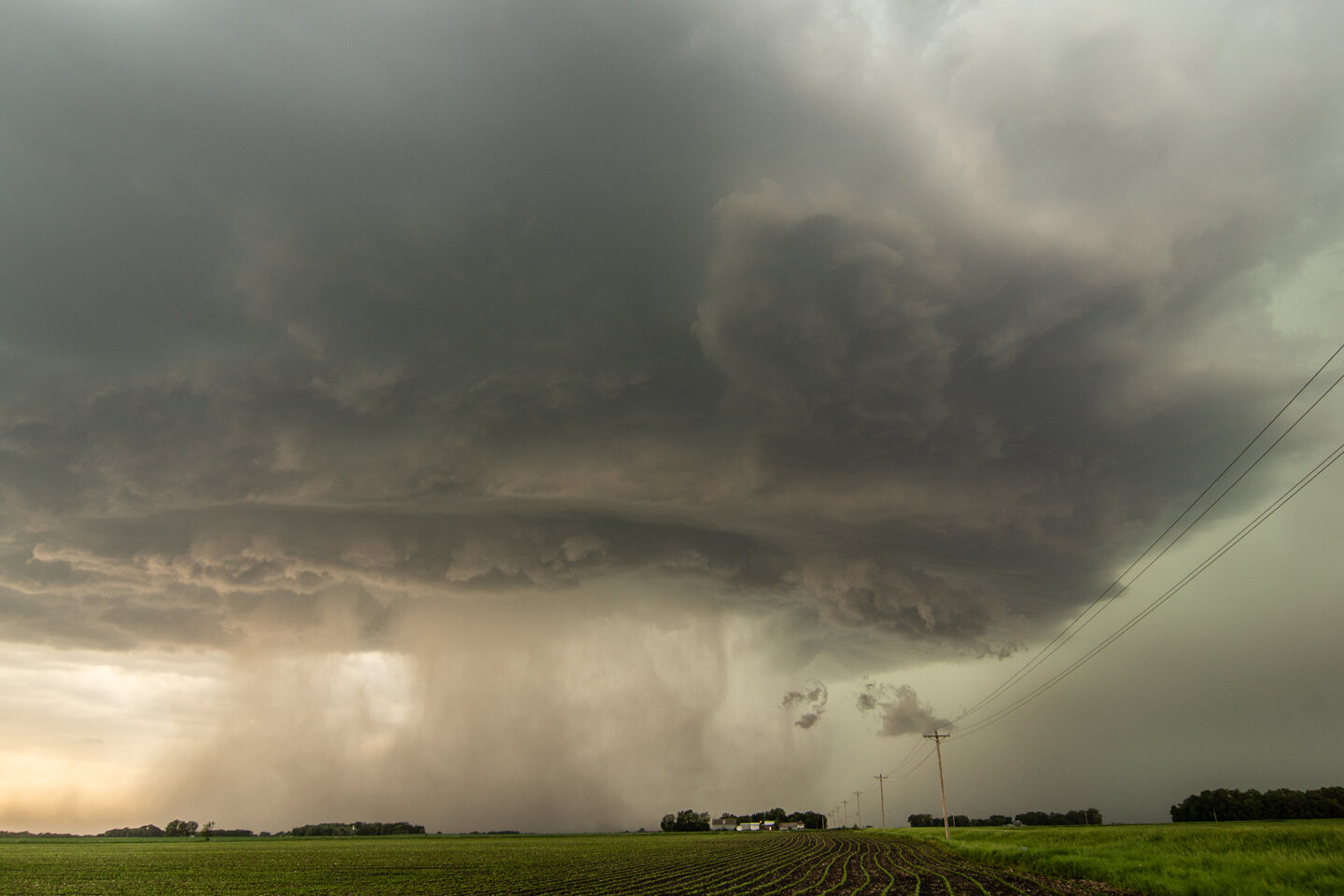
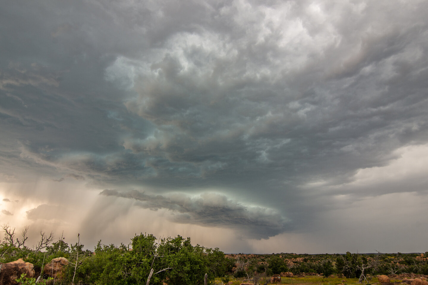
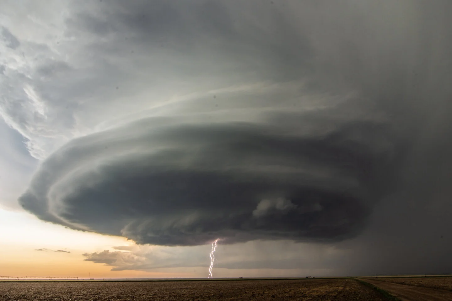
Wall cloud on what is now a tornado warned storm in Blaine, MN.

Another shot of the wall cloud in Blaine, MN as it was tightening up and becoming better organized.

DSC_4777.jpg

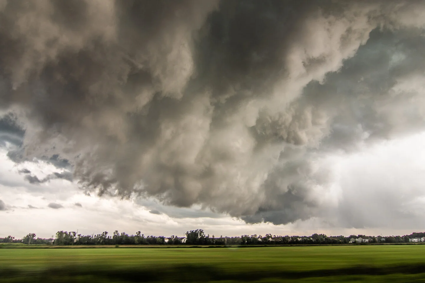
Turbulent underside of the wall cloud as it overtook us and moved to our southeast. This was as we were approaching White Bear Lake.

DSC_4788.jpg

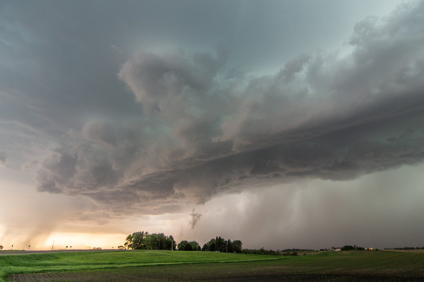
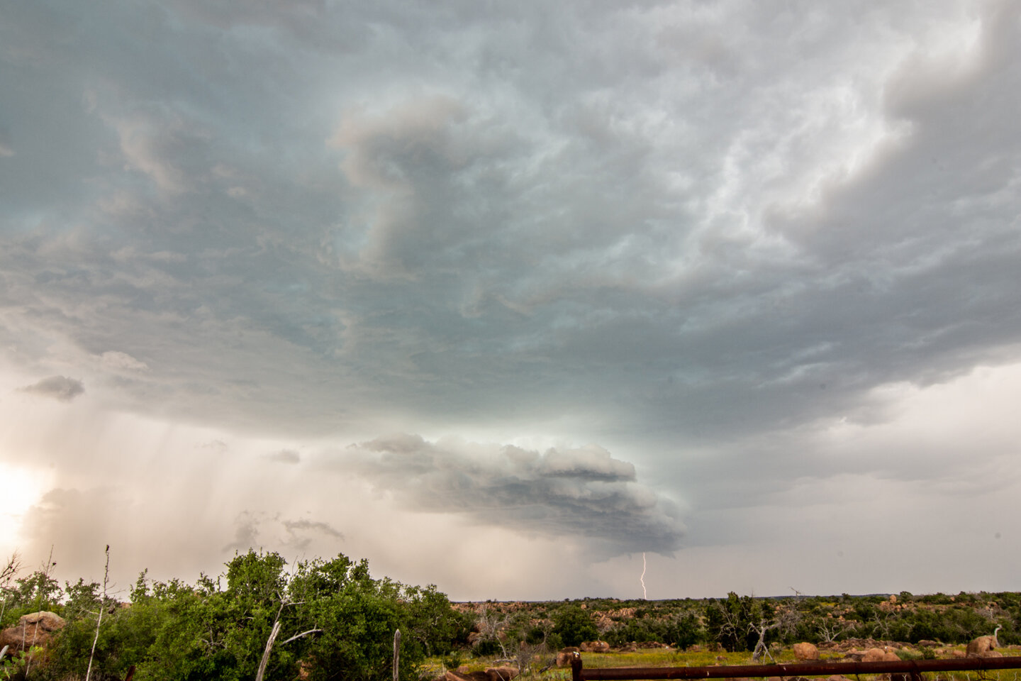
East of Hugo, MN the storm became even better organized. Thought it was going to produce a tornado here!

DSC_4793.jpg

Driving back home after our chase had ended. Beautiful storm erupting at sunset over Eagan, MN.

DSC_4796.jpg

Taken from my driveway. Love this shot of two storm updrafts approaching Farmington and gap in between!

DSC_4806.jpg

Shot of the storm to the east of our house, lit by lightning in the evening.

mcd1264.gif

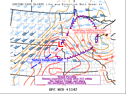
Mesoscale discussion issued at 3:12 PM CDT for central and southern Minnesota into northwest Wisconsin. 95% chance of watch issuance! Strong instability nosing into the southern half of Minnesota. https://www.spc.noaa.gov/products/md/2020/md1264.html

ww0382_radar_init.gif

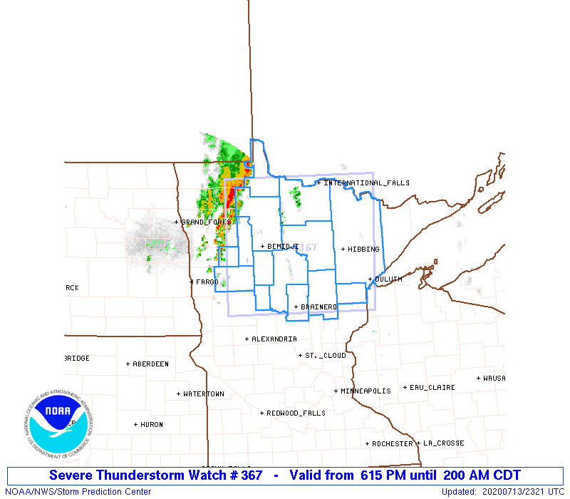
Severe thunderstorm watch issued at 3:55 PM CDT. https://www.spc.noaa.gov/products/watch/2020/ww0382.html

mcd1267.gif

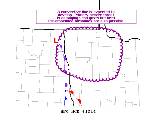
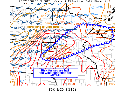
The next mesoscale discussion issued at 6:15 PM CDT as one lone tornado warned storm was trucking through the northern Twin Cities metro (which we were on), while new storms were developing west and north. https://www.spc.noaa.gov/products/md/2020/md1267.html

mcd1268.gif

Mesoscale discussion issued at 8:36 PM CDT for most of northern Wisconsin and the UP of Michigan. Severe storms moving east into Wisconsin. This was near when we called off the chase north of Hudson, WI and let the storms go. https://www.spc.noaa.gov/products/md/2020/md1268.html

ww0383_radar_init.gif

Severe thunderstorm watch issued at 9:40 PM CDT ahead of the developing broken squall line now across western Wisconsin. https://www.spc.noaa.gov/products/watch/2020/ww0383.html

STORM REPORTS:

200718_rpts_filtered.gif

STORM PREDICTION CENTER OUTLOOKS:

Outlooks.jpg

JULY 13, 2020 MINNESOTA: WAITING AROUND FOR A GOOD EVENING STORM


DSC_4669.jpg

An intense rain and hail core on our initial storm to the southwest of Ottertail, Minnesota.

DSC_4670.jpg

Vertical shot of the storm updraft above the intense rain and hail core.

DSC_4679.jpg

Wall cloud forming on the storm with quick right to left condensation into the base.

DSC_4701.jpg

Vibrant colors at sunset as the storm approached us near Deer Creek, Minnesota.

DSC_4703.jpg

Magnificent color and storm structure at sunset!

DSC_4710.jpg

Looking back to the east the other direction from the previous photo. Love the color of the blue sky and the backlit clouds from the setting sun.

mcd1214.gif

Mesoscale discussion issued at 3:52 PM CDT for northwest Minnesota ahead of the occlusion and low. We were just outside of this MD on the southern end near the triple point. https://www.spc.noaa.gov/products/md/2020/md1214.html

ww0367_radar_init.gif
mcd1217.gif

Mesoscale discussion issued at 7:34 PM CDT as new severe storms were expected to form during the evening ahead of the cold front. We were on the far northern end of this MD near Ottertail watching a strong storm towards sunset. https://www.spc.noaa.gov/products/md/2020/md1217.html

STORM REPORTS:

200713_rpts_filtered.gif

STORM PREDICTION CENTER OUTLOOKS:

Outlooks.jpg

JULY 8, 2020 MINNESOTA: AN EPIC EF4 TORNADO INTERCEPT AND #100 OF MY CHASING CAREER!!


DSC_4396.jpg

We were fortunate to be right on this storm at the initial updraft at it was punching through the CAP southeast of Fergus Falls, Minnesota. Stopped for 15 minutes to gas up and use the restroom and BOOM! the storm went up fast right on the warm front and ahead of the triple point.

DSC_4400.jpg

Wall cloud formed 20 minutes after the initial updraft went up. When this happens and you already have a lowering in a favorable storm environment, you know something special could happen. This was looking from the north near Dalton as the storm was moving northeast.

DSC_4420.jpg

Low contrast here but this was the initial tornado touchdown looking south from Dalton on Hwy 82 shortly after the last photo.

DSC_4442.jpg

Driving southeast on Hwy 82 as the tornadic circulation strengthens and the tornado “plants”. Perfect road to continue safely southeast as the tornado moves to the left (northeast) across I-94 at this point.

DSC_4450.jpg

Another shot of the tornado as we stopped near Hwy 82 and 130th St.

DSC_4506.jpg

Drove right up to the tornado as it slowly moved across Hwy 82, unfortunately hit a structure, and started throwing a lot of dirt in the debris field! Tornado was moving from our right and into the photo and left out of the photo. Did not want to turn left here as there was concern we would end up too close to the tornado path.

DSC_4509.jpg

UNBELIEVABLE!! At this point I knew we were witnessing a monster. Intense tornado with large debris field. We could hear the roar of the tornado at this point and smell all of the dirt, trees, and debris being chewed up and lofted. Can count on one hand the times I have experienced such exhilaration of the chase.

DSC_4510.jpg

Absolutely stunning tornado as we stood watching in awe.

DSC_4519.jpg

Large pieces of debris being thrown here as the tornado appeared to be fully wrapping up under the parent circulation.

DSC_4524.jpg

One of my favorite storm chasing photos I have ever taken here. Would be hard-pressed to ever get a shot like this again. This print is blown up large and hanging on my wall! Perfect spot to capture the white tornado with excellent contrast with no precipitation and sun illuminating everything.

Tornado started moving away from us as we watched from a distance while a rainbow forms and points towards the tornado base. Interesting white debris field here.

DSC_4558.jpg

Beautiful scene with a white tornado in the distance and a rainbow in the foreground. Such an awesome view to behold! This was somewhere north of Ashby, MN as we continued chasing the tornado to the northeast.

DSC_4571.jpg

Tornado starting to occlude as the storm condensation base erodes but still going strong northwest of Ashby, MN. Terrific contrast and debris cloud with rainbow.

DSC_4594.jpg

Wall cloud wrapping up with the white tornado in the distance.

DSC_4601.jpg

Look at the structure!! No rain around the tornado, wall cloud and mesocyclone as you’re able to see the tornado and twisting updraft overhead.

DSC_4616.jpg

Majestic white tornado starting to rope out between Sewell Lake and Johnson Lake, MN.

DSC_4625.jpg

Incredible and jaw dropping rope-out at the end of this tornado life cycle!

National Weather Service Review of the EF-4 Tornado: https://www.weather.gov/fgf/2020_07_08_Tornadoes

mcd1039.gif

Mesoscale discussion issued at 3:03 PM CDT. Notice the triple point of the low, trough and warm front where our tornadic storm formed just to the east. Storm rode that warm front with the enhanced low level shear and ingested rich boundary layer moisture pooling along the boundary. https://www.spc.noaa.gov/products/md/2020/md1142.html

ww0344_radar_init.gif
mcd1145.gif

Mesoscale discussion issued at 6:17 PM CDT as multiple tornadoes have occurred, with our EF4 ongoing with our lone supercell across west-central Minnesota. Storm right on the northern end of the instability axis. https://www.spc.noaa.gov/products/md/2020/md1145.html

mcd1147.gif

Mesoscale discussion issued at 7:58 PM CDT as new storms, a couple that did produce additional tornadoes, were forming along the warm front. https://www.spc.noaa.gov/products/md/2020/md1147.html

mcd1149.gif

Mesoscale discussion issued at 9:51 PM CDT as the severe weather risk continues as storms congeal. https://www.spc.noaa.gov/products/md/2020/md1149.html

STORM REPORTS:

200708_rpts_filtered.gif

STORM PREDICTION CENTER OUTLOOKS:

SPC Outlooks.jpg

JUNE 28, 2020 MINNESOTA: TORNADO WARNED SUPERCELLS AND A FEW FUNNELS


DSC_4320.jpg

First supercell of the day, storm base and intense core near Wells, MN.

DSC_4326.jpg

Intense core as the storm crept closer and right at us near Wells, MN.

DSC_4332.jpg

Wall cloud organizing on the same storm as we watched directly out ahead.

DSC_4342.jpg

Organized, rising scud finger that looked like a funnel but was not. However, wall cloud/lowering was rotating at this point.

DSC_4347.jpg

Rising scud finger still present with the wall cloud becoming more ragged near Austin, MN.

DSC_4349.jpg

Legit funnel cloud here as we watched the storm near Grand Meadow, MN

DSC_4355.jpg

Funnel cloud still there in the middle of the wall cloud and easy to identify inflow tail condensating right to left into the action area.

DSC_4360.jpg

Decent structure here of the storm base of a tornado warned supercell near Spring Valley, MN

DSC_4376.jpg

Beautiful wall cloud on a tornado warned supercell in the hill country near Preston, MN

DSC_4377.jpg

Rotating wall cloud on the storm near Preston, MN. Closest this storm came to dropping a tornado through its life cycle!

mcd1039.gif

Mesoscale discussion issued at 3:42 PM CDT for southeast Minnesota and north-central / northeast Iowa. Remnant MCV moving through the area and may produce a few funnels and a brief tornado. https://www.spc.noaa.gov/products/md/2020/md1039.html

ww0315_radar_init.gif

Tornado watch issued at 5:15 PM CDT for southeast Minnesota and a couple counties in northeast Iowa. https://www.spc.noaa.gov/products/watch/2020/ww0315.html

mcd1044.gif

Mesoscale discussion issued at 7:20 PM CDT as the severe threat continues. https://www.spc.noaa.gov/products/md/2020/md1044.html

STORM REPORTS:

200628_rpts_filtered.gif

STORM PREDICTION CENTER OUTLOOKS:

Outlooks.jpg

JUNE 8, 2020 NEBRASKA: MEAN TORNADO WARNED SUPERCELL AT DUSK


DSC_4221.jpg

Mammatus on the northern storm as we were approaching after crossing the dam at the Missouri River near Pickstown, SD.

DSC_4232.jpg

Approaching from the northeast on the farthest north severe thunderstorm in a broken line through east-central Nebraska. Can see a lowering here where the mature wall cloud is wrapping into the mesocyclone.

DSC_4234.jpg

Severe warned supercell near Dustin, NE as we were driving south to chase a stronger storm. Terrific structure!

DSC_4247.jpg

Approaching the stronger supercell to the south near Atkinson, NE. This storm soon becomes tornado warned.

DSC_4254.jpg

Wall cloud in the notch of this storm on the northern side of the storm base where the mature mesocylone was occluding.

DSC_4259.jpg

Dual mesocyclones looking to our south towards Atkinson, NE

DSC_4261.jpg
DSC_4265.jpg

Another view of the wall cloud trying to tighten up. Inflow tail and fast right to left condensation into the storm at this point. Hard to tell if there’s anything that is touching down in there due to all of the dirt and generally low visibility.

DSC_4268.jpg

Screaming inflow to our backs into this wall cloud at this time. This is when it looked the most interesting in regards to potentially producing a tornado. Was still tornado warned at this point.

DSC_4270.jpg

Very interesting. Rapid inflow right to left into this rotating wall cloud. Still can’t see what’s going on in there.

DSC_4271.jpg

Lots of dirt being pulled into this storm with screaming fast inflow from our backs.

DSC_4274.jpg

End of the chase during the evening as a strong and intense line of heavy rain and hail as approaching. Looking northwest from near Bristow, NE.

mcd0882.gif

Mesoscale discussion issued at 3:16 PM CDT. 80% chance of watch issuance along and ahead of the stalled boundary from eastern South Dakota into central Nebraska. We were positioned in Mitchell, SD on the northern end of where thunderstorms were expected to develop. https://www.spc.noaa.gov/products/md/2020/md0882.html

ww0272_radar_init.gif
mcd0885.gif

Mesoscale discussion issued at 7:16 PM CDT for central Nebraska where a localized tornado threat existed. https://www.spc.noaa.gov/products/md/2020/md0885.html

mcd0887.gif

Mesoscale discussion issued at 9:13 PM CDT as severe storms were moving north along the front into South Dakota. https://www.spc.noaa.gov/products/md/2020/md0887.html

STORM REPORTS:

200608_rpts_filtered.gif

STORM PREDICTION CENTER OUTLOOKS AND VERIFICATION:

day1otlk_v_20200608_1630.gif
day1probotlk_v_20200608_1630_torn_prt.gif
day1probotlk_v_20200608_1630_wind_prt.gif

JUNE 7, 2020 MINNESOTA: TORNADO WARNED SUPERCELLS NEAR THE CANADA BORDER


DSC_4156.jpg

First severe thunderstorm of the day near Karlstad, MN. Heck of a core here!

DSC_4172.jpg

Decent structure on the storm near Donaldson, MN. Inflow scud condensing on the right side.

DSC_4175.jpg

Rotating wall cloud wrapping up quickly near Lake Bronson, MN.

DSC_4180.jpg

Got up close to the wall cloud northeast of Lake Bronson, MN with a nub funnel trying to form in the middle. Very fast condensation right to left into this wall cloud.

DSC_4181.jpg

Funnel in the middle as the wall cloud tightened up.

DSC_4184.jpg

Another shot of the funnel becoming more ragged here but the white wall cloud in front of us tightening up.

DSC_4203.jpg

Tornado warned storm, again near Donaldson, MN at the end of the day. Lots of interesting features/motion underneath this base.

mcd0869.gif

Mesoscale discussion issued at 2:00 pm CDT. 95% chance of a tornado watch being issued. Severe thunderstorms expected to develop with a tornado threat, especially along the warm front. https://www.spc.noaa.gov/products/md/2020/md0869.html

mcd0870.gif

Another mesoscale discussion issued further southwest into South Dakota and northern Nebraska at 2:04 pm CDT. Another watch likely to be issued ahead of the low and trough. https://www.spc.noaa.gov/products/md/2020/md0870.html

ww0267_radar_init.gif
ww0268_radar_init.gif
mcd0874.gif

Mesoscale discussion issued at 5:55 pm CDT with tornado threat increasing. https://www.spc.noaa.gov/products/md/2020/md0874.html

mcd0875.gif

Mesoscale discussion update issued at 6:00 pm CDT for the severe thunderstorm watch area in South Dakota. Mentions hail and wind being the main threats but notice on the storm reports that all the tornadoes were in this area! https://www.spc.noaa.gov/products/md/2020/md0875.html

mcd0877.gif

Mesoscale discussion issued at 8:42 pm CDT. Image describes what’s going on… starting to merge into a cluster/QLCS while more discrete cells remain in our area we were chasing in far northwest Minnesota. https://www.spc.noaa.gov/products/md/2020/md0877.html

STORM REPORTS:

200607_rpts_filtered.gif

STORM PREDICTION CENTER OUTLOOKS:

Outlooks.jpg

JUNE 6, 2020 SOUTH DAKOTA: OUTRUNNING A DERECHO!


DSC_4069.jpg

Storm developing and rolling off the northern end of the Black Hills of South Dakota near Sturgis.

DSC_4085.jpg

Shelf cloud approaching very quickly on Highway 34 east of Sturgis. Bear Butte on the right.

DSC_4088.jpg

Looking northwest towards Bear Butte as the intense squall line and shelf cloud was overtaking it.

Beautiful vertical shelf stretching the skyline over the open prairies of western South Dakota.

DSC_4098.jpg

Interesting to see all of these notches in the shelf cloud and rotation signatures on radar as the derecho attempted to overtake us.

DSC_4102.jpg

Beautiful shelf still moving on us fast near Union Center, South Dakota.

DSC_4108.jpg
DSC_4111.jpg

Interesting feature here where there was strong rotation and a lowering underneath the base to our northwest. Sure looked and felt outflow dominant.

Got ahead of the storm enough to see the updraft above the derecho. Was cool to see these updrafts above the derecho staggered down the line.

DSC_4133.jpg

Derecho really started to become less linear as it moved into west-central South Dakota and form what looked like mesocyclones with noticeable rotation within each segment along the front on radar.

DSC_4136.jpg

Enjoying the storm with my beautiful wife, MaryLynn! Looking north into the Cheyenne River Reservation.

DSC_4147.jpg

Beautiful end to the chase day as we reached Pierre, South Dakota just ahead of the derecho.

mcd0854.gif

Mesoscale Discussion issued at 1:27 PM CDT noting a 95% chance for a severe thunderstorm watch to be issued due to widespread damaging winds with a significant bowing line of storms moving across the region. https://www.spc.noaa.gov/products/md/2020/md0854.html

ww0263_radar_init.gif
mcd0856.gif

Mesoscale Discussion issued at 3:33 PM CDT as more isolated supercell storms were possible to form ahead of the derecho moving across Colorado and Wyoming. Storm tried to get going and we even chased one storm from the Black Hills north but it ended up dying due to the capped airmass. https://www.spc.noaa.gov/products/md/2020/md0856.html

ww0264_radar_init_resize.gif

New severe thunderstorm watch issued at 5:45 pm CDT until 1:00 am CDT as the derecho was starting to approach western South Dakota. Wind gusts up to 80 mph and large hail events up to 2” in diameter. https://www.spc.noaa.gov/products/watch/2020/ww0264.html

mcd0861.gif

Mesoscale discussion issued at 8:29 pm CDT as a new severe thunderstorm watch needed to be issued ahead of the fast moving derecho. We stayed out ahead and managed to get to Pierre before it hit! https://www.spc.noaa.gov/products/md/2020/md0861.html

ww0265_radar_init_resize.gif

New severe thunderstorm watch issued at 9:10 pm CDT after the last mesoscale discussion and ahead of the derecho. https://www.spc.noaa.gov/products/watch/2020/ww0265.html

mcd0863.gif

Mesoscale discussion issued at 11:34 pm CDT highlighting the area of the greatest wind threat. https://www.spc.noaa.gov/products/md/2020/md0863.html

STORM REPORTS:

200606_rpts_filtered.gif

STORM PREDICTION CENTER OUTLOOKS:

Outlooks.jpg

JUNE 2, 2020 MINNESOTA: TORNADO WARNED SUPERCELL


DSC_3958.jpg

Tornado warned storm near Janesville, Minnesota. Condensation being pulled into the updraft base. Could have easily been mistaken for a funnel cloud.

DSC_3973.jpg

Not too often that you see this kind of awesome structure in Minnesota!

Interesting feature here as there was clear dirt/debris being lofted and a funnel overhead. Tough to tell if this was a tornado or gustnado on the leading edge of the outflow.

Barley dodging an intense hail core!! We blasted ahead to stay out of this core but it was close.

DSC_4010.jpg

Prolific scud bomb near Ellendale, Minnesota. This was called in as a tornado believe it or not. Definitely not a tornado but ominous looking for sure!

DSC_4050.jpg
DSC_4053.jpg

Beautiful end of the day and mammatus near Stewartville, Minnesota.

mcd0783-352pm.gif

Mesoscale Discussion issued at 3:52 p.m. CDT detailing the increasing coverage of thunderstorms and risk for hail and damaging winds as a cluster of storms progresses southeast into a higher unstable airmass. https://www.spc.noaa.gov/products/md/2020/md0783.html

ww0239_radar_init.gif

Severe thunderstorm watch issued at 4:40 p.m. CDT, valid until 12:00 a.m. CDT. Main threats included significant wind gusts to 75 mph and large hail up to 2” in diameter! https://www.spc.noaa.gov/products/watch/2020/ww0239.html

mcd0785.gif

Mesoscale discussion issued 5:32 p.m. CDT as ongoing severe thunderstorms continue to track southeast along the cold front into the greater instability. Another watch was issued ahead of these storms into southern Wisconsin. https://www.spc.noaa.gov/products/md/2020/md0785.html

STORM REPORTS:

200602_rpts_filtered.gif

STORM PREDICTION CENTER OUTLOOKS:

Outlooks.jpg

MAY 27, 2020 TEXAS: STORM CHASE FROM ABILENE TO SAN ANTONIO


DSC_3774.jpg

Daytime cloud to ground strike on our initial supercell near Coleman, Texas.

Storm struggling with dewpoints only in the upper 50’s and lower 60’s. High based and somewhat outflow dominant.

DSC_3801.jpg

Shelf cloud on outflow dominant supercell approaching Fredericksburg, Texas.

DSC_3925.jpg
mcd0739.gif

Mesoscale Discussion issued at 12:08 p.m. CDT for risk of severe hail and wind with developing storms.

mcd0742.gif

Mesoscale Discussion issued at 12:44 p.m. CDT for anticipation of a Watch to be issued soon in advance of developing storms.

ww0231_radar_init.gif

Severe Thunderstorm Watch issued at 1:45 p.m. CDT valid until 9:00 p.m. CDT. Primary threats include... Widespread large hail and isolated very large hail events to 3 inches in diameter likely. Scattered damaging wind gusts to 70 mph likely. A tornado or two possible.

mcd0746.gif

Mesoscale Discussion issued at 3:40 p.m. CDT for intensifying storms to produce severe wind and hail threats through 5-6 p.m.

mcd0747.gif

Mesoscale Discussion Issued at 5:05 p.m. CDT outlining potential for another watch to be issued downstream of the original watch.

ww0232_radar_init.gif

The next Severe Thunderstorm Watch issued at 5:20 p.m. CDT as severe storms continue to intensify and move southeast towards San Antonio.

mcd0749.gif

Mesoscale Discussion issued at 7:11 p.m. CDT for the storm we were on indicating hail size to increase as it approaches the San Antonio metro area.

mcd0750.gif

Mesoscale Discussion issued at 9:35 p.m. CDT for large hail and strong wind gusts with the storms moving over and near the San Antonio area. We got out ahead and bailed north on I-35 to get ahead of the hail before it could reach the interstate at the end of our chase day.

STORM REPORTS:

200527_rpts_filtered.gif

STORM PREDICTION CENTER OUTLOOKS:

MAY 24, 2020 KANSAS: VIOLENT, DANGEROUS SUPERCELL AND MICROBURST


DSC_3526.jpg

Initial intercept of an intense supercell storm coming out of southeast Colorado. Warned for 70+ mph winds and ping pong ball size hail!

DSC_3532.jpg

Beautiful structure on this mean looking storm!

DSC_3537.jpg

Possible tornado under the updraft base but could easily be concentrated area of rear flank downdraft winds coming around the south side of the mesocyclone.

DSC_3542.jpg

Microburst in the center of the image descending to the ground.

DSC_3543.jpg

Closer view of the microburst quickly descending. I bet this thing produced nearly 100 mph winds when it hit the ground.

Beautiful storm! Looking northwest towards the forward flank core.

DSC_3561.jpg

Nature’s vacuum! 50 mph inflow winds to our back being sucked into this storm. Notice all of the dirt being pulled into the updraft region and up into the storm.

DSC_3567.jpg

Terrific storm structure near Hugoton, Kansas. WHAT A BEAST

DSC_3569.jpg
DSC_3611.jpg

Getting dark later in the evening as the storm rages on near Hugoton, Kansas.

DSC_3642.jpg

Awesome structure and starting to throw out some lightning!

DSC_3668.jpg
DSC_3706.jpg
DSC_3709.jpg
mcd0705.gif

Mesoscale Discussion issued at 2:15 p.m. CDT. We were in Garden City and initially thinking of staying east on these storms but decided to blast west towards the intense storm coming out of Colorado.

mcd0706.gif

Mesoscale Discussion issued at 2:28 p.m. CDT. This area was really drawing our attention as the short range guidance was indicating one intense supercell rolling out of southeast Colorado.

ww0220_radar_init.gif

Severe Thunderstorm Watch issued at 3:45 p.m. CDT for the area we were targeting.

mcd0716.gif

Small Mesoscale Discussion issued at 7:06 p.m. CDT for our storm moving into southwest Kansas.

STORM REPORTS:

200524_rpts_filtered.gif

STORM PREDICTION CENTER OUTLOOKS:

Outlooks.jpg

MAY 22, 2020 TEXAS: INTENSE SUPERCELL AND 2 BRIEF TORNADOES ALONG THE RED RIVER


DSC_3371.jpg

Initial updraft of the storm breaking the cap by late afternoon near Haynesville, Texas.

Intensifying storm starting to anvil out, looking above our heads as lightning was becoming more frequent.

DSC_3387.jpg

Initial wall cloud forming as the storm begins to mature and track east along the Red River between Haynesville and Burkburnett, Texas.

DSC_3392.jpg

A pair of funnels underneath the updraft.

DSC_3396.jpg

Tornado warned storm kicking up dirt on the south side of the bowl lowering near Burkburnett, Texas.

DSC_3402.jpg

Brief tornado underneath bowl funnel. Notice concentrated area of dirt being picked up right in the middle of the picture.

Another shot of the tornado and funnel above that is more noticeable than the previous image. Clear concentrated rotation within this dirt plume.

DSC_3409.jpg

Concentrated rising scud into the storm base and some structure in this shot, taken near Thornberry, Texas.

DSC_3415.jpg

Nice structure on this storm as we got further out ahead near Thornberry, Texas.

DSC_3418.jpg

Another very good structure shot!

DSC_3423.jpg

Watching this wall cloud attempt to organize near Petrolia, Texas.

Shot of the well organized inflow tails into this storm, right to left, and a wall cloud still intact. Some semblance of a funnel or bowl lowering underneath.

DSC_3433.jpg

Second brief tornado, noticeable by the debris cloud underneath the funnel and wall cloud near Petrolia, Texas. Lucky to get a view here as this area is hilly with a lot of small trees and brush.

DSC_3439.jpg

Two wall clouds here, one in the foreground and background. Latter produced the tornado that was shown in the previous photo. Thought the one in front could do the same thing.

One more shot of the matured wall cloud and storm towards the end of the day as it was about to overtake us.

mcd0668.gif

Mesoscale Discussion issued at 12:55 p.m. CDT with expectation of thunderstorm initiation within the next hour. Interestingly enough, thunderstorm initiation occurred much later and closer to 5-6 p.m. as the cap held and initial towers could not sustain.

mcd0672.gif

Mesoscale discussion issued at 1:25 p.m. CDT for developing severe weather threat on northern edge of the highest CAPE axis.

ww0203_radar_init.gif

Initial Severe Thunderstorm Watch issued at 1:25 p.m. CDT.

mcd0674.gif

Mesoscale Discussion issued at 6:20 p.m. CDT indicating threat of tornadoes for 1-2 hours with the storm we were on just south of the Red River.

ww0205_radar_init.gif

New Severe Thunderstorm Watch issued at 6:55 p.m. CDT.

mcd0678.gif

Mesoscale Discussion issued at 9:26 p.m. CDT for ongoing severe weather threat. We were forced to go east to I-35 and head back north to Oklahoma City to get past the more intense supercells.

mcd0679.gif

Mesoscale Discussion issued at 11:56 p.m. CDT.

STORM REPORTS:

200522_rpts_filtered.gif

STORM PREDICTION CENTER OUTLOOKS:

MAY 21, 2020 KANSAS: STORM STRUCTURE OF THE YEAR!


DSC_3084.jpg

Wall cloud starting to organize on the first storm of the day in Holly, Colorado. Soon after became tornado warned.

DSC_3094.jpg

Storm chasing 2020 COVID-19 style! Wall cloud and funnel look-alike inflow tail in Holly, Colorado. Storm is tornado warned at this point and the sirens were blaring.

DSC_3098.jpg

Another view of the wall cloud on the tornado warned storm over the southern part of Holly, Colorado.

DSC_3101.jpg

Nice structure on the storm as it was moving over Holly, Colorado and threatening to overtake us.

DSC_3132.jpg

The second supercell was even better! Stacked plates and broad meso on the storm near Ulysses, Kansas.

Another shot of the supercell near Ulysses, Kansas.

DSC_3175.jpg
DSC_3196.jpg

It just gets better and better! 3rd supercell of the day near Satanta, Kansas. Incredible structure!

DSC_3237.jpg

Just awesome. Epic storm structure and popping cloud to ground lightning near Satanta, Kansas. What an experience!

DSC_3242.jpg

Double cloud to ground lightning strikes in one shot… yes please.

Incredible storm continues to amaze.

DSC_3273.jpg

Mammatus and stacked plates on a mothership over the wide-open Plains of southwest Kansas. Can’t be beat.

DSC_3283.jpg
DSC_3288.jpg

Funnel cloud emerging on the tornado warned storm near Satanta, Kansas.

DSC_3314.jpg

Funnel cloud just to the right of the lightning strike nearly touching down.

DSC_3324.jpg

Funnel cloud still holding together just above the light from the farmhouse in the distance. What a structurefest of a day!

mcd0657.gif

Mesoscale discussion issued at 2:20 p.m. CDT for development of storms within the next few hours and a risk of large hail and damaging winds.

ww0198_radar_init.gif

Severe Thunderstorm Watch issued at 3:15 p.m. CDT.

ww0200_radar_init.gif

Severe Thunderstorm Watch issued at 9:50 p.m. CDT ahead of the squall line surging southeast into northwest Oklahoma.

mcd0661.gif

Mesoscale discussion issued at 9:10 p.m. CDT indicating the primary severe weather threat for the next few hours.

mcd0663.gif

Mesoscale discussion issued at 11:28 p.m. for the enhanced severe weather threat with the squall line surging southeast.

STORM REPORTS:

200521_rpts_filtered.gif

STORM PREDICTION CENTER OUTLOOKS:

Outlooks.JPG

MAY 20, 2020 WYOMING AND COLORADO: SEVERE STORMS & LIGHTNING SHOW

Had a great day chasing storms in eastern Wyoming and northern Colorado! Best supercell storm of the day was near Keota, Colorado during the evening. This storm put on an incredible lightning show for us. First day guiding for http://www.silverliningtours.com/

DSC_2824.jpg

Nice cloud to ground strike on our initial storm in southeast Wyoming. I think this was on the storm near Chugwater.

DSC_2852.jpg

Tough to see but another CG out of our initial storm of the day near Chugwater, WY. Turbulent skies.

98203635_188758505613322_949177567573704704_n.jpg

Taking shots of the storm.

DSC_2958.jpg

CG’s out of the storm and a couple of separate storm bases near Keota, CO.

DSC_2997.jpg

Another arcing CG lightning strike out of the storm as we positioned out ahead near Keota, CO.

98594656_2974560572625059_6267311733971353600_n.jpg

Watching the storms and taking shots at sunset.

DSC_3041.jpg

Beautiful lightning near Keota, Colorado. All following lightning shots are from near Keota. Awesome display after sunset during the evening.

DSC_3048.jpg
DSC_3058.jpg
DSC_3069.jpg

STORM REPORTS:

200520_rpts.gif

STORM PREDICTION CENTER OUTLOOKS:

day1otlk_20200520_1630_prt.gif
day1probotlk_20200520_1630_hail_prt.gif
day1probotlk_20200520_1630_torn_prt.gif
day1probotlk_20200520_1630_wind_prt.gif