
JULY 8, 2020 MINNESOTA: AN EPIC EF4 TORNADO INTERCEPT AND #100 OF MY CHASING CAREER!!
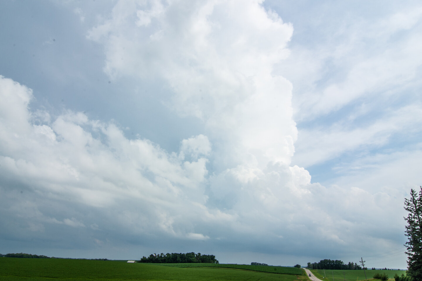
We were fortunate to be right on this storm at the initial updraft at it was punching through the CAP southeast of Fergus Falls, Minnesota. Stopped for 15 minutes to gas up and use the restroom and BOOM! the storm went up fast right on the warm front and ahead of the triple point.

Wall cloud formed 20 minutes after the initial updraft went up. When this happens and you already have a lowering in a favorable storm environment, you know something special could happen. This was looking from the north near Dalton as the storm was moving northeast.

Low contrast here but this was the initial tornado touchdown looking south from Dalton on Hwy 82 shortly after the last photo.

Driving southeast on Hwy 82 as the tornadic circulation strengthens and the tornado “plants”. Perfect road to continue safely southeast as the tornado moves to the left (northeast) across I-94 at this point.

Another shot of the tornado as we stopped near Hwy 82 and 130th St.

Drove right up to the tornado as it slowly moved across Hwy 82, unfortunately hit a structure, and started throwing a lot of dirt in the debris field! Tornado was moving from our right and into the photo and left out of the photo. Did not want to turn left here as there was concern we would end up too close to the tornado path.

UNBELIEVABLE!! At this point I knew we were witnessing a monster. Intense tornado with large debris field. We could hear the roar of the tornado at this point and smell all of the dirt, trees, and debris being chewed up and lofted. Can count on one hand the times I have experienced such exhilaration of the chase.

Absolutely stunning tornado as we stood watching in awe.

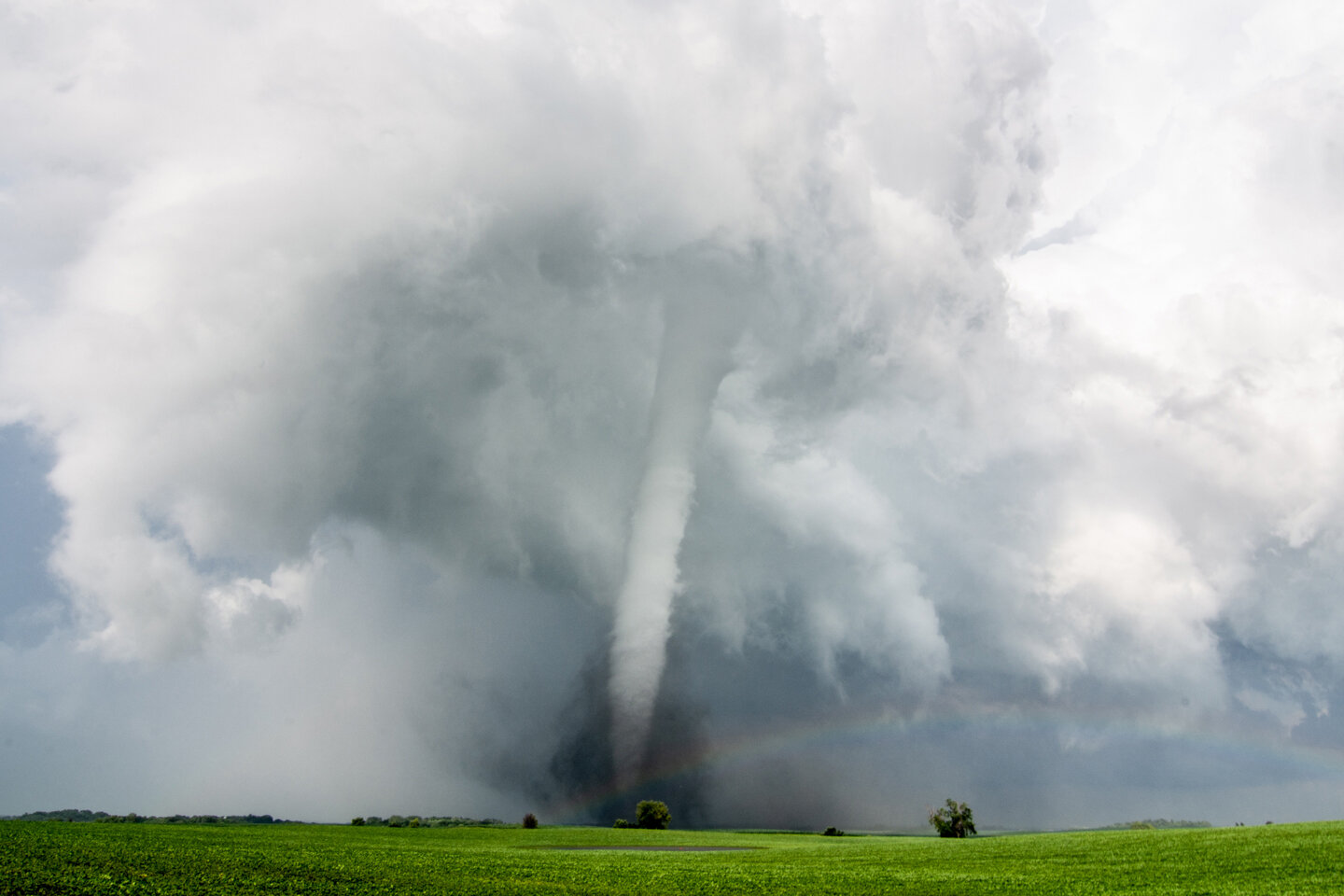
Large pieces of debris being thrown here as the tornado appeared to be fully wrapping up under the parent circulation.

One of my favorite storm chasing photos I have ever taken here. Would be hard-pressed to ever get a shot like this again. This print is blown up large and hanging on my wall! Perfect spot to capture the white tornado with excellent contrast with no precipitation and sun illuminating everything.

Tornado started moving away from us as we watched from a distance while a rainbow forms and points towards the tornado base. Interesting white debris field here.

Beautiful scene with a white tornado in the distance and a rainbow in the foreground. Such an awesome view to behold! This was somewhere north of Ashby, MN as we continued chasing the tornado to the northeast.
Tornado starting to occlude as the storm condensation base erodes but still going strong northwest of Ashby, MN. Terrific contrast and debris cloud with rainbow.

Wall cloud wrapping up with the white tornado in the distance.

Look at the structure!! No rain around the tornado, wall cloud and mesocyclone as you’re able to see the tornado and twisting updraft overhead.

Majestic white tornado starting to rope out between Sewell Lake and Johnson Lake, MN.

Incredible and jaw dropping rope-out at the end of this tornado life cycle!
National Weather Service Review of the EF-4 Tornado: https://www.weather.gov/fgf/2020_07_08_Tornadoes
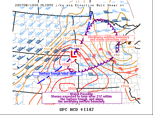
Mesoscale discussion issued at 3:03 PM CDT. Notice the triple point of the low, trough and warm front where our tornadic storm formed just to the east. Storm rode that warm front with the enhanced low level shear and ingested rich boundary layer moisture pooling along the boundary. https://www.spc.noaa.gov/products/md/2020/md1142.html


Mesoscale discussion issued at 6:17 PM CDT as multiple tornadoes have occurred, with our EF4 ongoing with our lone supercell across west-central Minnesota. Storm right on the northern end of the instability axis. https://www.spc.noaa.gov/products/md/2020/md1145.html

Mesoscale discussion issued at 7:58 PM CDT as new storms, a couple that did produce additional tornadoes, were forming along the warm front. https://www.spc.noaa.gov/products/md/2020/md1147.html
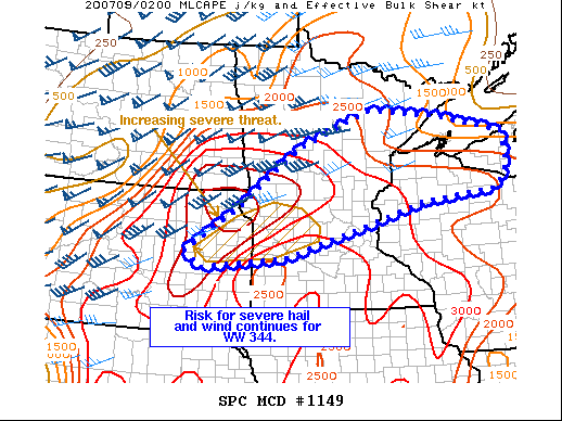
Mesoscale discussion issued at 9:51 PM CDT as the severe weather risk continues as storms congeal. https://www.spc.noaa.gov/products/md/2020/md1149.html

