JUNE 22, 2017 NORTHERN IOWA: TERRIFIC SUPERCELL STORM STRUCTURE

  Took a trip down to Iowa with my wife, MaryLynn, to see the Bridges of Madison County, see other sites, and then chase some storms.  There was not a lot of expectations on this day with limited deep layer shear and instability, but storms were likely to form on and ahead of the cold front in an environment that had been worked over some by rain and storms early in the day.  A storm that did form in northern Iowa somewhat surprisingly became a supercell and took on terrific structure during the early to middle part of its life cycle.  This was the one good storm of the whole event and one of the few that became severe thunderstorm warned, as it formed and tracked along a remnant outflow boundary and cold front intersection.  There was never a severe thunderstorm or tornado watch issued for the area as any severe storms were limited in coverage.

My favorite shot of the day of the incredible storm structure and striations with fully established shelf cloud near Hansell, Iowa.  Photo out of sequence from the others below.

DSC_0381.jpg

Multiple inflow tails to the base as we approached from the north near Meservey, Iowa.

Got a little closer and I was surprised at the well developed wall cloud that had formed on the southeast side!  Clearly can see the multiple inflow bands and I think the band of clouds right in front of us in this image is the actual outflow boundary the storm was rooted on.

Extremely low cloud base on this storm.  Looking west from near I-35 southeast of Meservey, Iowa.  The storm lost the wall cloud here but was still showing signs of strong inflow and rotation in a few spots.

Intense rain and hail core between Meservey and Chapin, Iowa.  Storm is severe thunderstorm warned at this point.

Awesome shelf cloud on the storm near Chapin, Iowa.

Looking the other direction from the previous image, to the north as the core of the storm was approaching.  Still some inflow into this storm as you can see from the bands on the left side.

Shot of the storm between Chapin and Hansell, Iowa with grain bins in the foreground and shelf cloud about to overtake.

Unreal structure near Hansell, Iowa!

Looking northeast at the vault region of the storm and shelf cloud at the base.

Storm looking mean as it gets near.

STORM PREDICTION CENTER OUTLOOKS

Mesoscale Discussion issued by SPC at 9:09 PM CDT as isolated severe thunderstorms were ongoing along the front.  They did not analyze the outflow boundary through north-central and northeast Iowa, but there appeared to be one there.  Never did issue a severe thunderstorm watch since the storm coverage was low.

STORM REPORTS

JUNE 15, 2017 KANSAS SUPERCELL & CORE PUNCH

  Chased as a guide with Silver Lining Tours (http://www.silverliningtours.com/) on this trip.  Got on a developing storm from the first updraft and followed it throughout its maturation cycle  from near Hays, Kansas southeast to near Newton.  The storm was tornado warned much of the time and exhibited terrific structure initially, producing baseball size hail in Hays, and morphed into a dangerous squall line producing damaging winds near 70 mph later in its life cycle.  The video shows a few time lapse segments from this storm, followed by our core punch through the squall line at the end of the chase.

Focused gustnado on the leading edge of the outflow and shelf cloud.  This was called in as a tornado by other chasers but appeared to be a gustnado over a tornado from our vantage point.  Gustnadoes are much weaker and produced differently than tornadoes, but can still kick up a lot of dirt!  This photo is out of sequence with the others below.

Supercell in early stages south of Hays, Kansas.  Lowering and brief funnel cloud in this image formed on the left side of the core.

Zoomed out view of the previous image, showing the brief funnel left of the core and supercell taking on very good structure.

Awesome structure with intense core/microburst occurring, and storm starting to go outflow dominant in central Kansas.

Right side of the core as supercell is going outflow dominant.  We are positioned southeast of the storm with storm motion being to the southeast towards us.

Group of Silver Lining Tours guests enjoying the view of an intense supercell storm near Hoisington, Kansas.

Still some inflow occurring on the northeast side of the intense rain & hail core over the open prairie of central Kansas.

Just another shot of the previous gustnado image a few moments later.

Gustnado washing out here but can still see the debris plume on the leading edge of the outflow winds on the left side where the gustnado was focused.

Severe thunderstorm moving towards us.  Stopped to get a shot of the storm as a backdrop to the limestone fence posts.  As you can imagine, there were not a lot of trees on the prairies of Kansas so, when these fences were built, they used limestone rock for posts since this was more readily available.  Cool to see these scattered about the countryside.

Mammatus clouds ahead of the storm to the east of Great Bend, Kansas.

Looking northwest at the approaching storm over a Kansas wheat field.

STORM PREDICTION CENTER OUTLOOKS

Mesoscale Discussion issued by the Storm Prediction Center at 12:49 PM CDT, outlying the risk area for an upcoming Severe Thunderstorm Watch.

Severe Thunderstorm Watch issued for central and eastern Kansas at 1:25 PM CDT.  This is the area highlighted for expected wind gusts of 60-80 mph.  You can see our storm just getting going southwest of Hays, Kansas.

Another Mesoscale Discussion issued at 3:29 PM CDT, highlighting the environment our storm was moving into and the possibility of 60-80 mph winds as the storm started to bow out into an intense line.

Another Mesoscale Discussion is issued at 5:58 PM CDT as the threat of damaging winds continues with the storms forming a bowing line.

A new Severe Thunderstorm Watch issued at 7:05 PM CDT ahead of the bowing line forming a severe MCS (mesoscale convective system).

STORM REPORTS

JUNE 13, 2017 SOUTH DAKOTA: SUPERCELLS & GUSTNADOES

  This was the third day of chasing as a guide for Silver Lining Tours (http://www.silverliningtours.com/).  The day before, we caught 3 brief tornadoes and a beast of a storm in Wyoming and Nebraska.  We got ahead of this same system near the South Dakota/Nebraska border area on this day.  The thought was storms would form off the cold front/dryline and be rotating supercells with a decent chance to produce a tornado, although temperature/dewpoints spreads were fairly large.  A second target existed on the warm front across northeast South Dakota into west-central Minnesota but we thought the storms here would be too messy and congeal too quickly to stray from our closer target.  There did end up being a nice tornado in that second target area across west-central Minnesota.  We managed to catch a few severe and tornado warned supercells, as well as several gustnadoes on our storms.  There were a few tornado reports from the storms we were on, but we could not confirm that these were tornadoes over gustnadoes. 

First arriving on the supercell with a wall cloud near Bonesteel, South Dakota.  Storm had some decent structure at this point.

  Looking at the northern side of the base and updraft with the core of the storm on the right and wall cloud on the left.

  Cool shot of the approaching storm and a grain silo in the foreground.  

Looking west towards the approaching supercell near Pickstown, South Dakota.  This is the spot where I shot the time-lapse video above.

Gustnado occurring down the road from our location on the bottom right of the image.  Storm core coming in from right to left along with the shelf cloud.

Another shot of the storm and gustnado that is was producing near Wagner, South Dakota.  This was called in as a tornado by multiple sources but appeared to be a gustnado to me due to outflow of the storm and no condensation funnel above.

Looking at a tornado warned storm to the west, while the tour group enjoys the spectacle.

Rainbow on the backside of a different storm as we were getting close to sunset.  A few of the guests caught lightning and this rainbow in their shots.

At sunset on the back of the storm, looking southwest.  Cool looking sky with good color, mammatus clouds and the shot of an anvil from another storm in the distance.  

Terrific looking sky at sunset looking west in northeast Nebraska.

STORM PREDICTION CENTER OUTLOOKS

Mesoscale Discussion issued by SPC at 2:32 PM CDT, highlighting the threat for storms to develop by 21Z with primary threats being wind damage and hail, along with some tornado threat.

Tornado Watch issued at 3:15 PM CDT for the area, valid until 10:00 PM CDT.

Another Mesoscale Discussion issued at 3:46 PM CDT from eastern Nebraska into southeast South Dakota and northwest Iowa.  Additional storms expected to form ahead of the initial storms that we were chasing along the South Dakota/Nebraska border.

A Mesoscale Discussion issued at 5:43 PM CDT as intense storms were maturing and new storms started to fire on the warm front and ahead of the low on the triple point.

Mesoscale Discussion issued at 8:34 PM CDT for the storms that were congealing and becoming less discrete across the eastern Dakotas into eastern Nebraska and western Minnesota.

STORM REPORTS

JUNE 12, 2017 WYOMING & NEBRASKA CHASE: 3 TORNADOES & BEASTLY SUPERCELL AT DUSK

  I was chasing as a guide for Silver Lining Tours (http://www.silverliningtours.com/) for this one.  We had high hopes that this would be the best chase of the tour as conditions were ripe for rotating supercells and tornadoes.  A trough was ejecting out of the Rockies and into the northern High Plains, with more than sufficient low and deep layer wind shear.  Bulk shear as in the area of 65 knots.  A nose of 3,000-4,000 J/KG of MLCAPE developed into western Nebraska and eastern Wyoming, allowing for a very unstable airmass.  Shear, lift, instability and moisture appeared sufficient for a tornado outbreak to occur.  We ended up seeing 3 brief tornadoes on the day, only one shown below and in the video from a distance.  I was driving during the other 2 tornadoes.  The first supercell that we chased was from near Chugwater, Wyoming to Torrington, Wyoming.  The second supercell became large, photogenic and very intense.  We chased this storm from near Bayard to Alliance, Nebraska.  

Storm looking even more amazing as it approached our location.  Love those stack of plates!  This photo is out of sequence with the others.

First storm of the day exploding on the mountains to the west of Chugwater, Wyoming.  Wall cloud already developing on the left side of the core.

Wall cloud trying to organize to the east of Slater, Wyoming.  Moderately fast inflow occurring from right to left into this base.

Another wall cloud in the foreground trying to organize.  Large, low-hanging rising scud bomb in the distance being pulled into the base and around the wall cloud.  This was near Rockeagle, Wyoming.

Wall cloud tightening up and spinning near Rockeagle, Wyoming, shortly after the previous image.

Had a bad road network here, so only could capture this tornado from a distance as we looked west from near Lingle, Wyoming.

Multiple low inflow bands pulling in rich moisture with the second supercell we chased near Bayard, Nebraska.  A short time before, this the storm developed two brief tornadoes.  I was driving the van at that point and not able to capture a photo.

Awesome mothership structure, stacked plates, and shelf cloud on the storm as it became high precipitation (HP) near Angora, Nebraska.

Mothership about to engulf a train between Angora and Alliance, Nebraska.

Storm spitting out lightning left and right as it was about to overtake us.  Had to get out of the way shortly after this as the storm had huge hail within the core.

Another shot of the lightning and mothership supercell south of Alliance, Nebraska towards sunset.

Plenty of cloud-to-ground lightning to go around!  Was popping lightning all over the place and the storm was very intense at this point.  Tornado warned with a considerable couplet on radar embedded in the high precipitation monster.

Another shot of the lightning at dark.  Had to get out of the way shortly after this photo as it was a very dangerous, intense supercell.

STORM PREDICTION CENTER OUTLOOKS

Mesoscale Discussion issued at 11:29 AM MDT, already talking about issuing a tornado watch as thunderstorms develop over the next few hours.

Tornado Watch issued at 1:10 PM MDT, valid until 8:00 PM MDT.

New mesoscale discussion issued at 5:05 PM MDT for the area with greatest risk for strong tornadoes and all severe weather hazards.

Mesoscale discussion issued at 8:02 PM MDT as dangerous supercell thunderstorms continued to move northeast through Nebraska, western South Dakota and northeast Wyoming.

STORM REPORTS

MAY 16, 2017 TEXAS & OKLAHOMA STORM CHASE: TORNADOES & INCREDIBLE LIGHTNING

  This was the day we had been waiting for and the reason for the whole trip.  An upper trough was ejecting out into the Plains with strong 55-65 knot winds at 500 mb, amble moisture, instability and strong wind shear to allow for rotating supercells and tornadoes.  Wes Hyduke and I left Garden City, Kansas late morning and made our way down to west of McLean, Texas off I-40 to get in position.  We encountered 3 separate supercell storms, starting near McLean, Texas and ending near Sentinel, Oklahoma.  The McLean storm produced a photogenic tornado, while the storm near Sayre, Oklahoma had a tornado debris spin-up underneath the bowl lowering and mesocyclone.  This second storm is the one that brought the big rain-wrapped tornado that led to extensive damage in Elk City, Oklahoma.  This was followed by a spectacular cloud-to-ground lightning show near Gotebo, Oklahoma.  A great chase day!

Awesome elephant trunk tornado near McLean, Texas.  We stopped next to a Doppler on Wheels truck to view the tornado in the distance as it was churning away.  This photo is out of sequence with the others below.

Wall cloud on the first tornado warned storm of the day near the Gray County Rest Area, to the west of Alanreed, Texas.

Wall cloud on a second tornado warned storm east of Howardwick and south of Alanreed.  Taking on terrific structure at this point with inflow tail on the right into the base and condensating wall cloud.  This was the storm that produced the tornado near McLean a short while later.

WE'VE GOT COWS!  Had to evade a herd of cattle on dirt road 20 south of Alanreed and northeast of Clarendon, Texas.  Was a funny moment when we were trying to get in position to intercept a tornado warned storm heading towards McLean.

Approaching the tornado warned storm southwest of McLean, Texas on highway 273.  Wall cloud with large inflow tail right to left into the storm.  

Radar grab showing our location close to the time the previous photo was taken.

TORNADO!  Beautiful elephant trunk to rope tornado south of McLean, Texas as we were driving north on highway 273.

We drove up highway 273 towards McLean and looked off to the left to see the tornado still going strong!  I am still not sure if this was a second tornado or in the roping out stage of the first tornado.  Could have rotated around the mesocyclone and back west.  Appeared to me to be a 2nd tornado on a new updraft off the dryline well to the west of the first tornado, but cannot be sure.

A zoomed in view at the base of the tornado south of McLean, Texas.  There was decent rotation at the base of the tornado towards the end of its life cycle but it did not appear to be violent.

Tornado in roping out stage towards the end of its life-cycle.

Rainbow below and exploding supercell updraft as we approached a new storm northeast of Vinson, Oklahoma.

One of the best inflow tails that I have ever seen.  This thing was like a conveyor belt of warm, moist air into the storm base and shooting directly into the updraft.  Near Sayre, Oklahoma.

Another tornado spinning up dirt directly underneath a fast spinning mesocyclone near Sayre, Oklahoma.  A beautiful storm at this point!  Thought this was going to drop a big multiple vortex tornado right in front of us, but it never grew beyond this.

Awesome storm structure with beaver tail, wall cloud, quickly rotating mesocyclone and dusty tornado underneath near Sayre, Oklahoma.

Had to get a photo in front of this storm!  It had everything.

A short while later as the mesocyclone was approaching.  Still a fast rotating wall cloud, somewhat rain-wrapped, and producing funnel after funnel.

Meso really getting close at this point.  Strong rotation and funnel very close to the ground.  May have touched down again here but not for certain.  Still southeast of Sayre and west of Carter, Oklahoma.

Very close to producing a tornado here.  Strongly rotating wall cloud and funnel.  This is looking directly into the notch from the northeast side near the forward flank core.  Had to get out of here shortly after this photo was taken.  The storm later went on to produce a large tornado that hit Elk City, Oklahoma.

Ended the day with a terrific cloud to ground lightning show near Gotebo, Oklahoma.

UNREAL lightning strike that occurred directly in front of our car and right in the middle of my camera frame!  Probably will never get a lightning shot even comparable again in my lifetime.  Fortunately, I was in the car and had a remote trigger for my camera, which was outside on a tripod.  Camera settings were ISO 100, f/22, and 20 second exposure.

STORM PREDICTION CENTER OUTLOOKS

Mesoscale discussion issued at 1:19 PM making note of the tornado watch that will be issued shortly.

Particularly Dangerous Situation (PDS) tornado watch issues at 1:50 PM until 10:00 PM CDT.  Note the high likelihoods for tornadoes, wind and hail.  

New mesoscale discussion issued at 4:56 PM, highlighting the small area where tornado risk would be greatest as well as extremely large hail.  This area highlighted was where the 2 storms in which we saw tornadoes were located.

Another mesoscale discussion issued at 7:29 PM, highlighting a continued tornado risk east of where the current tornado watch was in place.

STORM REPORTS

MAY 15, 2017 KANSAS STORM CHASE

  Wes Hyduke and I left Minnesota on this morning and drove to northwest Kansas where we intercepted a couple of photogenic supercell thunderstorms.  This chase was primarily by chance as we were on our way to chase in the Texas Panhandle the next day.  We decided to take a detour to view the storms in northwest Kansas and glad that we did.

Captured a cloud-to-ground lightning strike out of the storm as we watched from the southeast side.  This photo is out of sequence with the others below.

Terrific mammatus display on the storm as we approached near Hill City, Kansas.

Looking directly upwards at the mammatus clouds under the anvil on the storm west of Hill City, Kansas.

The storm started to get some decent structure near Hoxie, Kansas.  I love chasing in the wide open Plains!

Looking at the storm updraft and inflow bands feeding into it near Hoxie, Kansas.  Severe thunderstorm at this point.

Great structure on the storm at this point but storm starting to congeal and become more of a cluster.

A left-moving low precipitation supercell north of Garden City, Kansas at the end of the day.

STORM PREDICTION CENTER OUTLOOKS

MESOSCALE DISCUSSION ISSUED FOR THE AREA AT 3 P.M. CT.

Severe Thunderstorm Watch Issued at 3:40 PM

STORM REPORTS

JUNE 19TH MINNESOTA: TORNADO WARNED SUPERCELL

 
DSC_0381
DSC_0381

Intercepting a tornado warned supercell west of Lake Shore at the intersection of Cty Rd 1 and 88th St.  Nicely structured storm with inflow streamers, large base and wall cloud.  The lowering/wall cloud was tough to make out until the storm got closer due to being shielded by rain.

DSC_0382
DSC_0382

Looking a bit to the right of the base and updraft at the intense core that went on to produce baseball size hail near Nisswa.

DSC_0385
DSC_0385

A closer view of the wall cloud west of Lake Shore, Minnesota. There was clear rotation at this point and fairly fast condensation into the base.

DSC_0387
DSC_0387

Wall cloud started to become more ragged as it approached my location but still evident tucked in right by the core and underneath the base.

DSC_0389
DSC_0389

Wall cloud forming over North Long Lake to my east.  This is where I came across a vehicle that was down in the ditch and backwards, close to the lake.  I checked on him and the guy was ok and had already called for help.

DSC_0392
DSC_0392

Wall cloud becoming better organized east of North Long Lake as I watched to the west.  Attempted to catch up with the storm right after this but got slowed going through Brainerd.

DSC_0398
DSC_0398

View of the strong and still tornado warned high precipitation (HP) supercell moving north of Mille Lacs Lake. This was taken in Garrison looking northeast.

DSC_0399
DSC_0399

Double rainbow north of Ogilvie, Minnesota.  WHOA, A DOUBLE RAINBOW!!

DSC_0410
DSC_0410

Base of the former tornado warned storm, and lightning, near Big Lake, Minnesota at the end of the day.

MESOSCALE DISCUSSION:

MN MD
MN MD

SEVERE THUNDERSTORM WATCH:

ww0273_radar_init
ww0273_radar_init

STORM REPORTS:

160619_rpts_filtered

SPC OUTLOOKS:

day1otlk_20160619_1630_prt
day1probotlk_20160619_1630_hail_prt
day1probotlk_20160619_1630_torn_prt
day1probotlk_20160619_1630_wind_prt

JUNE 14TH MINNESOTA: NUMEROUS FUNNEL CLOUDS & 2 TORNADOES


Longer version featuring highlights from the entire chase:

DSC_0227
DSC_0227

Wall cloud lowering on the first storm near Arco, Minnesota.  This cell did not look like much on radar but was spinning like mad and had solid inflow!

DSC_0231
DSC_0231

First funnel cloud of the day on the storm near Arco, Minnesota.  This storm produced several more funnels.

DSC_0254
DSC_0254

Another funnel that was rapidly rotating and condensing near Porter, Minnesota.  This funnel was 3/4 of the way to the ground but we cannot confirm there was any touchdown in the field right in front of us.  I believe we were on Highway 7 to the south of Porter at this time.

DSC_0263
DSC_0263

Another view as the storm moved just to our north and the wall cloud was really tightening up with a continuous funnel cloud.  The wall cloud occluded soon after this as the funnel dissipated.

DSC_0268
DSC_0268

Took a little while but we eventually got on the next storm after the first one died.  This wall cloud was forming with apparent inflow scud fingers near Big Stone Lake on the Minnesota/South Dakota border.

DSC_0273
DSC_0273

Another wall cloud quickly forming on the storm southeast of Beardsley, Minnesota.

DSC_0283
DSC_0283

Another funnel cloud quickly formed and dissipated on the storm.  Very high sheared air feeding these storms at this point but not a lot of instability.

DSC_0293
DSC_0293

The most pronounced and lowest funnel cloud of the day that did not produce a tornado.  Never could see if this touched down but it had to be close.

DSC_0311
DSC_0311

Hard spinning storm updraft and developing funnel cloud southeast of Beardsley and southwest of Barry, Minnesota.  Strong inflow occurring at this point.

DSC_0333
DSC_0333

Funnel cloud forming out of the hard spinning and tightening wall cloud shortly after the previous photo.  A textbook scenario of fast inflow to the right wrapping into the notch and rear flank downdraft winds cutting around the backside of wall cloud/updraft to eventually produce a beautiful tornado.

DSC_0355
DSC_0355

Rope funnel cloud starting to condense to the ground as the storm was moving north of our location.

Beardsley MN Tornado

Video still of tornado and white debris cloud.

Beardsley MN Tornado 2

Another video still showing stretching vorticity in action!  Long, white rope tornado.

Beardsley MN Tornado 3

Another video still of the long tube.

MESOSCALE DISCUSSION:

MN MD
MN MD

TORNADO WATCH:

ww0255_radar_init
ww0255_radar_init

STORM REPORTS:

160614_rpts_filtered

SPC Outlooks

Outlooks
Outlooks
 

MAY 8TH OKLAHOMA: TORNADO WARNED SUPERCELL & ROTATING WALL CLOUDS

 
DSC_0056
DSC_0056

Developing storm in the foreground with beautiful crepuscular rays coming through the clouds.

DSC_0060
DSC_0060

First developing storm north of Woodward, Oklahoma.

DSC_0065
DSC_0065

Wall cloud/lowering on the storm as it was starting to get its act together near Freedom, Oklahoma.

DSC_0067
DSC_0067

Rotating wall cloud underneath the updraft of the storm west of Alva, Oklahoma.

DSC_0068
DSC_0068

Another view of the condensing, rotating wall cloud.

DSC_0072
DSC_0072

Strong updraft as the storm reaches its strongest point.

DSC_0073
DSC_0073

New wall cloud forming after the old one weakened and occluded.

IMG_3986
IMG_3986

iPhone shot of the wall cloud west of Alva, Oklahoma.

DSC_0077
DSC_0077

Doppler on Wheels (DOW) heading down the road to re position as the wall cloud we were watching weakened and dissipated.

DSC_0080
DSC_0080

Strongest rotation of the day on this wall cloud that was tightening up near Alva, Oklahoma.  This likely would have produced a tornado at this point if the dewpoints were higher than the lower to middle 60s.

DSC_0085
DSC_0085

Condensing lowering on the wall cloud, possibly funnel.  Very tilted updraft from left to right on this storm.

IMG_3987
IMG_3987

My position (blue crosshairs) relative to the hook echo north of Alva, Oklahoma.

MESOSCALE DISCUSSIONS:

OK MD
OK MD
OK MD 2
OK MD 2

TORNADO WATCH:

ww0149_radar_init
ww0149_radar_init

STORM REPORTS:

160508_rpts
160508_rpts

SPC OUTLOOKS:

day1otlk_20160508_1630_prt
day1probotlk_20160508_1630_hail_prt
day1probotlk_20160508_1630_torn_prt
day1probotlk_20160508_1630_wind_prt

MAY 7TH COLORADO: SUPERCELL & FUNNEL

 
DSC_0040
DSC_0040

Supercell storm intensifying and still south of the warm front near Abarr, Colorado.

DSC_0041
DSC_0041

Wall cloud developing on the storm.  Notice clear slot behind the wall cloud where the rear flank downdraft cut was occurring.

DSC_0043
DSC_0043

Another shot of the storm as it was getting closer.  Sharp, flat base to the supercell at this point.  Dissipating wall cloud on the far right.

DSC_0047
DSC_0047

Silver Lining Tour guests and crew enjoying the show underneath the mammatus clouds.

DSC_0050
DSC_0050

Large storm base really taking on a C shape as the RFD cut became larger.

DSC_0054
DSC_0054

The storm near Vernon, Colorado as we began departing for Oklahoma City.  This storm went on to produce several tornadoes that we missed due to having to be back in Oklahoma City that night.

MESOSCALE DISCUSSION:

CO MD
CO MD

TORNADO WATCH:

ww0143_radar_init
ww0143_radar_init

STORM REPORTS:

160507_rpts
160507_rpts

SPC OUTLOOKS:

day1otlk_20160507_1630_prt
day1probotlk_20160507_1630_hail_prt
day1probotlk_20160507_1630_torn_prt
day1probotlk_20160507_1630_wind_prt

May 6TH WYOMING: SUPERCELL TIME LAPSE

 
DSC_0008
DSC_0008

Supercell storm rolling off the Laramie Range near Chugwater, Wyoming.  You can see the feeder bands from all directions into this storm.  Pulling in all the moisture that it can, considering dewpoints were only in the middle 40s.

DSC_0020
DSC_0020

Nicely structured mothership supercell over the foothills of the Laramie Range in Wyoming.  You can see how this storm is rotating with the clouds twisting into the updraft.

DSC_0025
DSC_0025

Another shot of the supercell as it was starting to move out over the flatter Plains near and east of Chugwater.  Storm starting to weaken some at this point.

DSC_0031
DSC_0031

Storm weakening but holding onto some good structure with well defined high-based inflow bands and storm base.

DSC_0033
DSC_0033

View of the storm as another core was starting to open up right in front of us.  Was popping some cg lightning with this new core but could not capture any of the lightning in a photo.

STORM REPORTS:

160506_rpts
160506_rpts

SPC OUTLOOKS:

day1otlk_20160506_1630_prt
day1probotlk_20160506_1630_hail_prt
day1probotlk_20160506_1630_torn_prt
day1probotlk_20160506_1630_wind_prt

April 26TH KANSAS: SUPERCELL & ROTATING, TIGHT WALL CLOUD

 
DSC_0788
DSC_0788

Initial wall cloud on the first tornado warned storm near Caldwell, Kansas.

DSC_0794
DSC_0794

Funnel on the first tornado warned storm just to the north of Caldwell, Kansas near the Oklahoma border.  This funnel persisted for a few minutes before dissipating.

DSC_0814
DSC_0814

Rotating wall cloud tightening up into a funnel near Mayfield, Kansas.  Nearly produced a tornado at this point!

DSC_0815
DSC_0815

Zoomed out view of the tightened up rotating wall cloud and funnel near Mayfield, Kansas.  This area of focused rotation dissipated after the occlusion.

DSC_0823
DSC_0823

This scared dog jumped in the through the passenger door and into the driver's seat when we weren't looking, ha ha!!  Poor guy...felt bad kicking him out in the rain but couldn't take him with.

DSC_0839
DSC_0839

Severe thunderstorm over the wheat fields of southern Kansas.   Storm starting to become outflow dominant and form a shelf cloud at this point.

DSC_0866
DSC_0866

Shelf cloud and storm about to overtake us and a train near Wellington, Kansas.

DSC_0871
DSC_0871

Looking at the underside of the shelf cloud, whale's mouth, as it passed over near Wellington, Kansas.  Visually striking blue/green/aqua colors under this shelf.

IMG_3218
IMG_3218

Wes Hyduke's panorama of the underside of the shelf cloud at the end of the day near Wellington, Kansas.

MESOSCALE DISCUSSIONS:

ks MD
ks MD
OK MD
OK MD

TORNADO WATCHES:  

ww0108_radar_init
ww0108_radar_init
ww0109_radar_init
ww0109_radar_init

STORM REPORTS:

160426_rpts_filtered

SPC OUTLOOKS:

day1otlk_20160426_1630_prt
day1probotlk_20160426_1630_hail_prt
day1probotlk_20160426_1630_torn_prt
day1probotlk_20160426_1630_wind_prt

MARCH 23RD MISSOURI & IOWA: SEVERE THUNDERSTORMS

 
DSC_0726-2
DSC_0726-2

Inflow tail into the storm near Westboro, MO.

DSC_0731-2
DSC_0731-2

Caught a lightning strike in the intensifying storms near Westboro, MO.

DSC_0737-2
DSC_0737-2

Storm from above, now severe warned, dumping a hail core.

DSC_0741-2
DSC_0741-2

Ragged lowering at the base of the storm at the Hwy C and 59 intersection.

DSC_0744-2
DSC_0744-2

Rain/hail cores on severe warned storms east of Westboro, MO.

DSC_0746-2
DSC_0746-2

Storms becoming more organized and showing several feeder bands near Blanchard, IA.

DSC_0754-2
DSC_0754-2

Another shot of the severe warned storms just south of Blanchard, IA.

DSC_0756-2
DSC_0756-2

The southern storm in the line coming up at me with high base forming on the southeast side.

mcd0252
mcd0252

Mesoscale discussion issued during the early afternoon.  Hilarious they put a 'wedge-shaped area' in the discussion!

ww0051_radar
ww0051_radar

Tornado watch issued at 3 PM for the area.

SPC OUTLOOKS:

day1otlk_20160323_1630_prt
day1probotlk_20160323_1630_torn_prt
day1probotlk_20160323_1630_hail_prt
day1probotlk_20160323_1630_wind_prt

STORM REPORTS:

160323_rpts_filtered

MARCH 23, 2016 CHASE LOG: MISSOURI & IOWA

  I decided to chase this day, mainly to kick off the rust from my last chase on July 12, 2015 and to see some decent thunderstorms after the long winter season.  The set-up included a strong upper level trough going positive to negative tilt by later in the day, a 100 kt 500mb jet streak from Kansas into Iowa, and effective shear of 40-50 kts.  At the surface, a surface low moved from near north-central Kansas to southeast Nebraska with a trailing dryline to the south and a near stationary warm front through the southern tier of counties in Iowa.  The plan was to target storms that were expected to develop near and just south of the triple point by 21Z (4pm).  The main concerns for the day were the dewpoints only projected to get into the 52-55F range and be relatively confined to a shallow layer with dry air aloft, and the other concern having to drive back through a blizzard on the northern end of this system in northern Iowa and southern Minnesota.

I left that morning and headed south on I-35 to I-80 west, then south on Hwy 148 to Corning and eventually making my way down Hwy 71 to Clarinda.  I stopped here to take a look at the data and grab a bite to eat.  Realizing that storms were likely to first fire in southeast Nebraska and build to the southeast, I headed further west to Shenandoah to wait for initiation, as the town was right on the boundary and wobbling between temperatures from near 60F to lower 70s.  A tornado watch was issued at 3pm for the area, valid until 10pm that evening.  I was honestly a bit surprised with the tornado watch being issues as I had thought a severe thunderstorm watch would be issued instead due the moisture quality issues into the area.

Storms first fired to the west right on the north and east side of the low.  I waited for additional storms to begin forming to my south and, sure enough, cumulus towers started building about 30 minutes after the initial storms to my west.  I traveled south on Hwy 59 and intercepted storms near the intersection of this road and Hwy C, just across the border near Westboro, Missouri.  The storm updrafts were fairly chunky/fluffy going up and did not have that classic, hard look to them, but each storm developed a flat, smooth base and opened up some intense rain and hail cores.  I intercepted 4 separate storms in this area over the next few hours, 3 of which became severe thunderstorm warned for mainly large hail but also damaging winds.  Some of the storms did form some ragged lowerings and had some inflow feeder tails into them with some decent structure but, overall, I did not witness any areas of organized rotation and none ever came close to having any tornado potential.  One particular storm that I followed from east of Westboro north towards Blanchard, Iowa had the best structure of the day with a couple inflow tails and intense cores.  These storms congealed and moved north of the front, so I traveled east to stay out ahead of other storms coming up from the south.  I intercepted one of these storms in Hopkins, Missouri where small hail was coming down so heavy that it was running down the streets in rivers with intense rainfall as well.  Thereafter, I tried to get back out ahead of the storms, traveling east to I-35 and north through Des Moines and home, but managed to stay in the intense rainfall much of the way.  Near Dows, Iowa the heavy rain began transitioning to thundersleet and freezing rain where numerous vehicles were in the ditch, including big rigs.  After 10 miles of treacherous/slow driving, precipitation transitioned to very heavy snow and near white-out conditions.  I slowly made my way north to Mason City and the roads did get a little better to the north of town as the plows had been out.  I ended up eventually making it back to my parents place in southern Minnesota after hours of white knuckle driving.  What a crazy day going from severe thunderstorms to a blizzard, and lower 70s air to upper 20s air!

JULY 12TH MINNESOTA: FUNNELS & 2 BRIEF TORNADOES

 
DSC_0111
DSC_0111

A turbulent sky as elevated storms form north of the warm front over corn fields near Wendell, Minnesota.

DSC_0121
DSC_0121

A shelf cloud forming on the storm near Foxhome, Minnesota.  Severe warned for mainly hail at this point.

DSC_0125
DSC_0125

The first tornado touching down in the distance east of Doran, Minnesota as we watched on highway 19.

DSC_0125-2
DSC_0125-2

Cropped shot of the photo from above, showing the tornado.  Other chasers confirmed this indeed touched down.

DSC_0126
DSC_0126

Tornado lifted and formed a bowl shaped funnel in the middle of the wall cloud.

DSC_0131
DSC_0131

A few minutes later, this rope funnel appeared closer to our location on the lead storm.  This was a a few miles north-northeast of Campbell.  Thanks Tony for noticing this!  We were transfixed on the previous funnel as it was still present at this time to the right.

DSC_0134
DSC_0134

Elongated funnel cloud north of Campbell, Minnesota.

DSC_0139-2
DSC_0139-2

Beautiful funnel cloud on the storm a short while later!

DSC_0141
DSC_0141

Funnel wrapped up into a rope as the rear-flank-downdraft outflow started to undercut.

DSC_0147
DSC_0147

Around the time that this touched down as a tornado.  You can see this ground truth in the video.

DSC_0154
DSC_0154

Good structure on the high precipitation storm.

DSC_0159
DSC_0159

Intense storm near Barrett, Minnesota.

MESOSCALE DISCUSSION:

mcd1379
mcd1379

STORM REPORTS:

150712_rpts_filtered

STORM PREDICTION CENTER OUTLOOKS:

Outlooks
Outlooks

JULY 12th, 2015 CHASE LOG: MINNESOTA

  It’s not too often that a chase day turns out almost exactly like you thought it would…but this was one of those days!  Our group consisting of myself, Wes Hyduke, and Tony Perkins left Burnsville, MN around 12:45pm, heading northwest on I-94 towards west-central Minnesota.  My initial target for the day was Tenney.

Storm Setup:  A surface low set up just west of the North Dakota/South Dakota/Minnesota border area by the early afternoon with a warm front draped to the east through central Minnesota, and a trough to the south of the low through eastern South Dakota.  A mid-level trough was approaching the area from the west, while an extremely unstable environment was in place with dewpoints in the lower to middle 70s and 4,000-4,500 j/kg of MLCAPE.  Bulk shear was on the order of 35-45 kts with lower bulk shear north and higher south.  Ongoing, elevated convection reinforced the warm front ahead of the surface low into west-central Minnesota.

We traveled to Alexandria for gas and then northwest to Elbow Lake and parked at the intersection of Hwy 59 and Hwy 55 northwest of town.  This was an excellent spot to go any direction with good roads.  A mesoscale discussion (MD) was issued by the SPC from our location and areas north at 2:54 pm, while a more strongly worded MD was issued at 3:53pm from our location south through all of southwest MN and eastern SD.  This new MD highlighted a supercell and tornado risk in this area.  A Tornado Watch was issued a short while later.

Storms near Fergus Falls to our north quickly became tornado warned and we drifted towards them, all the while keeping in mind that new storms would likely form to the south of this initial cell.  We caught up with a new southwest updraft near Foxhome.  The storms to our northeast were tornado-warned but our storm was still developing and was severe-warned at the time.  I wasn’t about to go running to the storms northeast of our area that appeared to be north of the warm front and in a more stable airmass, so we stayed put on our storm as new towers developed to the southwest.  The storm we were on started to spew cold air and became very outflow dominant with a shelf cloud.  We bailed this storm quickly and headed south towards another storm that was really starting to get its act together.  Upon core punching a lead cell, we ended up south on Hwy 19 east of Doran.  We still hadn’t got out of the rain before noticing a well-defined lowering in the distance that was starting to take on a bowl shape.  Stopping to watch, a cone funnel appeared and condensed over halfway to the ground.  We later heard that this did indeed touch down, to our watch at 5:05pm.  As this funnel was starting to dissipate, Tony noticed a beautiful rope funnel just to our southwest on our lead cell!  This was the highlight of the chase as the rope twisted and turned for several minutes, changing shapes and growing/shrinking throughout.  As you can see in the video, this rope did touch down as it became undercut by the storm outflow as we watched northeast of Campbell.  This was at 5:15pm.

The chase continued through Nashua, Wendell, and Elbow Lake to the east and then down towards Barrett and Hoffman.  Upon the way, we saw some okay structure, well defined inflow bands, and some ragged lowerings that did not appear to be doing much.  This was more of a monster hailer and wind-maker more than anything at this point.  Upon chasing this storm east of Hoffman, we decided to call it a day as the storms were congealing into a line.  Driving south on I-94, we stopped for dinner, barely making it out of Sauk Centre before getting cored by the severe line.

JUNE 24TH IOWA: TORNADO WARNED HIGH-PRECIPITATION SUPERCELLS

 
DSC_0005
DSC_0005

Tornado warned supercell north of the warm front.  A heavy bank of low clouds and fog underneath the updraft bases of these storms.  An eerie scene driving into this to say the least, especially with it being tornado warned and all of the lightning/thunder this storm was producing.

DSC_0014
DSC_0014

This was the closest the storm came to producing a tornado from our vantage point.  This was a large, rotating mesocyclone with a developing wall cloud.  You can sense the scud being pulled around the backside of the meso and around to the left and then wrapping up into that white lowered area in the foreground.  It was spinning hard!

DSC_0019
DSC_0019

View of the base south of Panora as we were trying to get out ahead with the storm dive-bombing southeast.

DSC_0020
DSC_0020

White wall cloud to the north of Stuart on the tornado warned storm.  There was not much rotation here with this feature.

DSC_0025
DSC_0025

Further west on the tail end storm near Anita.  Notice the dark lowering in the distance.  This was the hook echo on radar and showed signs of lowered bowl before being undercut by outflow.

IMG_2823
IMG_2823

Panoramic shot from my iPhone of the entire storm near Anita, IA.  Inflow tail to the right, lowering in the distance to the left.  Large base in the middle.

0030
0030

A ragged lowering on the storm near Fontanelle.

0036
0036

Lightning!

DSC_0043
DSC_0043

Supercell slowing down on the tail end near Fontanelle.  Has okay structure here and still rather intense.  Popping lightning quite a bit.

DSC_0052
DSC_0052

Intense core on the storm at sunset and popping cg lightning like crazy.

DSC_0055
DSC_0055

Very intense core on this storm...so we decided to drive through it!  Ended up with nickel size hail as the storm appeared to weaken when we core-punched.

MESOSCALE DISCUSSIONS:

mcd1157
mcd1157
mcd1162
mcd1162
mcd1164
mcd1164

STORM REPORTS:

150624_rpts_filtered

STORM PREDICTION CENTER OUTLOOKS:

Outlooks
Outlooks

JUNE 24th, 2015 CHASE LOG: IOWA

  I had been keeping an eye on this day for a while and knew there was going to be some tornado potential with the kind of set-up the models were showing days in advance.  Myself, MaryLynn, and Allison Stupica left the Twin Cities early in the morning and took the kids down to my parents, then departed for Des Moines, Iowa.

Storm Setup:  Convection (some severe) lingered along a stalled warm front through central Iowa much of the day.  This pushed an outflow boundary into southwest Iowa where it was interacting with a stationary front right near the Iowa/Nebraska/Missouri border area.  Dewpoints along this boundary were very high and in 70-74F range, while temperatures heated up into the upper 80s and low 90s, providing considerable buoyancy for storms if they could develop.  Aloft, there was a speed max coming through Iowa late in the day with 40-45 kts of bulk shear, but some of this higher shear displaced just to the north.

The atmosphere sure took its time to destabilize and I believe the speed max moved in late.  We waited around into the afternoon at a restaurant in southwest Des Moines and eventually moved west towards an area that had been highlighted for a conditional supercell and tornado risk in southwest Iowa per a mesoscale discussion issued at 2:23pm.  As we were traveling west on Hwy 92 towards Greenfield and Fontanelle, we could see towers exploding to the north.  These quickly became severe as storms formed on an outflow enforced warm front and not on the ouflow boundary draped to the southwest.  We advanced north through Adair where we crossed I-80 and then further north to intercept a severe warned storm west of Guthrie Center.  It was very ominous driving up to the storm base where clouds appeared to be on the ground, and there was almost what looked like a fog bank set up south of the storm with such a warm and humid airmass being ingested into it.  A Tornado Watch was soon issued at 6:20pm as our storm became tornado warned and also the one to the east.  We followed the rapidly developing supercell that was already taking on high precipitation characteristics to the east on Hwy 44 towards Panora.  To the west of town, we stopped to watch and this is where it had a large, rotating mesocyclone and appeared ready to drop a tornado.  The storm was still tornado warned and the meso was spinning hard with rapid condensation taking place for a few minutes.  We traveled through Panora and south on P28 to escape the forward flank core and as the storm started to surge southeast.  We stopped once we got back to I-80 as the eastern storm now became tornado warned.  The tornado warned storm we were on was now dive-bombing southeast with a large, rotating mesocyclone and a lot of motion over the town of Stuart.  Folks in Stuart were a little freaked out by this and there were a lot of people out of their homes and some erratic driving by the locals as we traveled through town.

A new, tail-end supercell had been developing as we chased our storm to near Stuart, and we decided to blast west towards this storm that already had a hook echo and was severe-warned.  We had to blast through the RFD hook on our storm going west on I-80 to get to this cell and, as we did so, there was a lot of motion in the clouds, high winds, some hail and even some debris being lofted into the air.  It was difficult to figure out what was going on, but it appeared to be swirling RFD winds coming around the hook and possibly a few weak gustnadoes that we drove through.  We arrived on the next storm south of Anita on Hwy 148 and watched a lowering come at us to the northwest, but wash out as the outflow winds choked it off.  Staying ahead of this storm toward Berea and Fontanelle, the storm slowed down and took on some decent structure with occasional cloud-to-ground lightning that led to some photogenic opportunities.  We ended the chase here as the storm was high-precipitation and it was getting dark.

JUNE 20TH IOWA: HIGH-PRECIPITATION SUPERCELL & INCREDIBLE MAMMATUS

 
????????????????????????????????????
????????????????????????????????????
????????????????????????????????????
????????????????????????????????????
????????????????????????????????????
????????????????????????????????????
This was the closest that the storm came to producing a tornado.  Low wall cloud wrapping up on the east side of the storm updraft base.  This was just east of Eddyville, IA on G77 at the high school.
This was the closest that the storm came to producing a tornado. Low wall cloud wrapping up on the east side of the storm updraft base. This was just east of Eddyville, IA on G77 at the high school.
DSC_0354
DSC_0354

Awesome mammatus display east of Garwin, IA, looking south off Hwy 229.

DSC_0358
DSC_0358
DSC_0364
DSC_0364

The mammatus got even better a short while later near Traer, IA.Incredible mammatus field over Iowa farmland at sunset near Buckingham, Iowa!

FullSizeRender[1]
FullSizeRender[1]

Panoramic cell phone shot of the entire mammatus field laid out in front of us.

MESOSCALE DISCUSSION:

mcd1087
mcd1087

STORM REPORTS:

150620_rpts_filtered

STORM PREDICTION CENTER OUTLOOKS:

Outlooks
Outlooks

JUNE 20th, 2015 CHASE LOG: IOWA

  This was one of those chases that had a lot of potential, but didn’t quite live up to the hype.  For a few days in advance, myself and others were chatting that this could be a solid tornado day.  We stayed at MaryLynn’s parent’s house the night before and then left early Saturday morning to Deer Creek Speedway where my parents were going to watch Gage.  Wes and Debby Hyduke met us at Deer Creek close to 10am and we quickly departed for west-central Iowa down Hwy 63 towards Waterloo.

Storm Setup:  Morning convection cleared the area very fast, allowing for destabilization to occur with 3,000-4,000 j/kg of MLCAPE.  A surface low developed near Des Moines, while a stationary front was positioned to the northeast and a cold front moved across south-central Iowa.  Even though some of the low level shear was veered and led to lower 0-1km storm relative helicities, the 0-3km SRH values were near 250 m2/s2.  This was still quite supportive for rotating supercells and tornadoes.

A mesoscale discussion was issued at 3:10pm, while a Tornado Watch followed at 3:50pm for southeast Iowa, northern Missouri, and western Illinois.  We progressed south on Hwy 63 to the southern side of Waterloo to fill up for gas and grab food, then repositioned further south towards Tama.  The thinking was that we were right at the crossroads of a good road network and directly ahead of the surface low/triple point and south of the stationary front.  Storm initiation occurred shortly before 4pm directly to our west-northwest.  We waited for this storm to approach us as it was still in the developing stages, but did head about 5 miles to the west to check things out as it got closer.  The base of the storm was not very well defined and appeared rather ragged, but was low to the ground.  The storm was starting to produce a lot of lightning as it moved near and appeared to be strengthening.  At the same time, another storm had formed to the south and looked to be right on the triple point or just to the southeast.  This was the storm we wanted to be on as it quickly became severe warned shortly after initiation.

We traveled down to I-80 and west to exit 179, south on Hwy T38, and west on Hwy 102 to Pella where we intercepted the storm.  From here, we followed the severe storm that was producing big hail southeast on Hwy 163, barely escaping the hail core on the east side of Pella.  We got back on Hwy 63 and were able to get out ahead enough to stop a few times as we approached Eddyville.  Through the duration, the storm had some interesting lowerings and attempted a few times to produce wall clouds with decent inflow banding going on.  We exited at Eddyville and got just east of town on Hwy G77.  This is when the storm started to tighten up the wall cloud and the closest that it came to producing a tornado.  There were indications here that it produced a funnel cloud and this was reported by other chasers, but too hard to discern from our location.  After this intense moment, we had to drive through the forward flank core to get to our south option and back towards Hwy 63. This is where we encountered some very intense rain and some smaller hail with roughly 40 mph winds.  Wes had a good time driving out of that!  Thereafter, the storm started to gust out upon reaching Ottumwa, taking on linear characteristics, and had a nice shelf cloud before we decided to call off the chase.

On the way back home, we encountered some of the most amazing mammatus that I’ve ever seen and were able to stop a few times to take photos.  The colors and visibility of the mammatus field were incredible at sunset and definitely the highlight of the whole chase!

MAY 27TH TEXAS: FOUR TORNADOES NEAR CANADIAN

 
DSC_0090
DSC_0090

Initial supercell exploding 19 miles northwest of Canadian, Texas.  Well-defined base forming to the left of the hail core.

IMG_2696-2
IMG_2696-2

2 thumbs up to this amazing wall cloud and funnel, northwest of Canadian, TX!

????????????????????????????????????
????????????????????????????????????

Awesome storm and well defined wall cloud with funnel extending over halfway to the ground.

DSC_0130
DSC_0130

 Love this shot.  Roughly the time another storm chaser reported a tornado.  They were closer and saw a debris cloud at the ground...hence a tornado!

DSC_0147
DSC_0147

Another funnel forming northwest of Canadian a short while later as the wall cloud tightened back up.

DSC_0157
DSC_0157

Same funnel next to a rain/hail core.  This never did touch down.

DSC_0162
DSC_0162

Lightning out of the base.  Storm really twisting hard here with another wall cloud starting to develop as RFD punch develops clear slot on the southwest side of the storm.

DSC_0189
DSC_0189

Storm taking on a mothership appearance with large, circular base.  Large, ragged wall cloud underneath at this point.

DSC_0198
DSC_0198

Tornado #2!  Large cone/stovepipe tornado right in front of us, a few miles north of Canadian.

DSC_0198-2
DSC_0198-2

Closer shot of the tornado.

DSC_0201
DSC_0201
DSC_0204
DSC_0204

Tornado getting even larger with a big debris cloud.  Clouds with the inflow were screaming into it right to left here.Tornado taking on a definite cone shape as it sits nearly stationary.

DSC_0209
DSC_0209

Tornado takes an elephant trunk shape as the cloud base begins to erode and the circulation starts the occlusion process.

DSC_0209-2
DSC_0209-2

Closer shot of the tornado from the previous image.

DSC_0216
DSC_0216

After the tornado dissipates, a new and fast rotating wall cloud develops just to the east of the occluded meso.

DSC_0223
DSC_0223

Wall cloud moves east to west (right to left), being pulled into the parent mesocyclone of the storm.  The Silver Lining Tours crew looks on in amazement.

DSC_0239
DSC_0239

Tornado #3 just west of Canadian as we watch from the south side of town.

DSC_0256
DSC_0256

Lightning bolt out of the storm as it appears to become more outflow dominant.

DSC_0260
DSC_0260

Tornado #4!  This circulation did condensate and touch down just northwest of town.  This was the final attempt at producing a tornado.  What a day and storm!

STORM REPORTS:

150527_rpts_filtered

STORM PREDICTION CENTER OUTLOOKS:

Outlooks
Outlooks

MAY 27, 2015 CHASE LOG: TEXAS

Written by Rich Hamel: (www.bostonstormchaser.com/)

  We left Abilene at about 9:30 with the intent of targeting storms at a triple point set up on the Texas Panhandle. Our target for the day was Canadian, TX as the earlier model runs which had favored Kansas backed off that play significantly and favored the Texas Panhandle. We made good time and, after a quick lunch stop in Childress, were in Canadian by about 2 PM with nothing to do but wait, so we hung out at the Dairy Queen. At this point there were towers percolating on two distinct boundaries, one on the front just west of us and the other on the dry line, forming a triple point around Spearman.

After about an hour of waiting, the HRRR predicted monster was in its early stages of development and we left to chase it, heading about 5 miles out of town on Rt. 83 and pulling off on a side road to watch the storm grow. Our vantage point was perfect and soon the storm had classic structure with a vertical updraft (though it later tilted over hard), inflow bands, and a flanking line. It wasn’t long before it developed a nice wall cloud and not long after that dropped an elephant trunk funnel more than half way to the ground! It seemed like for sure the storm was ready to tornado, but after cycling through two additional larger funnels more than half way to the ground, the wall cloud dissipated and as the storm was slowly moving east, we had to as well. It turns out that the funnel did indeed contact the ground (from our vantage we couldn’t tell), tornado #1 for the day! But why is it that when you are in a perfect spot in terms of visibility, contrast, and everything else, they never put down a nice long tornado!!?

We headed back towards Canadian, stopping once more to view the storm as it cycled and generated a new wall cloud. The storm was barely moving, slowly drifting east, and was already becoming HP, so we had to see into the inflow notch to tell what was going on. We went northeast out of town on Rt. 60 and started experiencing significant amounts of chaser convergence, as well as a lot of other trucks that were stopped waiting for the storm to clear past the road which, as it turns out, took hours. We stopped and watched as the storm developed a lowering on the nose of the updraft in typical HP fashion and decided to head north to look into the notch. We weaved through heavy traffic and drove right up to the storm with the mesocyclone just a little in front of us and wild motion almost directly above the vans! Soon the meso was spinning away wildly just to our northeast and we got blasted by heavy RFD winds. We went even further north past the meso on the end of the hook to FM1920 where we watched another larger meso to our southwest move by. It looked like it could tornado right there, and the action was intense as we were pinned up against the front flank core by the meso, and once hail started falling we moved along with the meso to stay just ahead of the hail. As we did, the rotation to the right of the vans got stronger and stronger and soon a large cone shaped funnel lowered and contacted the ground. Tornado #2! This one was a big cone tornado at first heading straight at us about a mile away, then moving southeast, paralleling our direction as the storm dive bombed southeast, then later headed away from us as it curved around the meso. The cone grew in size and started to show a decent debris fan. One cool feature at this time was that you could look right up the clear slot and see up the whole updraft to the top of the storm. The tornado continued to intensify and grown into a larger cone until, after about 10 minutes the tornado roped out and that meso occluded, but no sooner had that happened then the next meso formed on the other side of the road from us and came towards us. We beat feet to get out of the way and stay ahead of the storm.

We traveled about a mile to get ahead of the new meso and watched as it crossed the road behind us, all the while throwing out funnels part of the way to the ground.  We continued on south of the town, parking near a small airport. The storm began to look a little strung out, but still had wild motion under multiple lowerings as each took turns being the focus of attention.  Soon to our west, the storm generated another tornado, this one an elephant trunk that turned into a multiple vortex, #3, then another multi-vortex which lasted a bit longer and looked almost stationary before getting swallowed by the rain core.. #4!! All the while the town’s tornado sirens were blaring.

Right after the 4th tornado, the storm belched out the strong, cold winds of outflow and a big precipitation core opened up under the updraft. The show was over for this storm.

After an Allsups break in Pampa, we proceeded towards Amarillo, intending to jump south towards Claude and another storm south of there in the Caprock Country but it was barely moving in the slow upper level winds: Unfortunately there was no road to get south on it, and even if we could, the roads in the canyons were slim and at the bottom of the valleys which made it hard to see anything. So we decided we couldn’t make it and gave up for the night, heading into town for dinner at the Big Texas steakhouse.

The night wasn’t quite done with us though as storms kept firing on the pinch point of a pair of boundaries south of town where our Claude storm had been, giving us quite a lightening show at the hotel.

What a great chase day! We only moved a total of about 10 miles over the course of the entire chase. Even an hour after we drove away from it, the Canadian storm, which was right over the town, was dumping water and hail amounting to over 4” of rainfall and causing flash flooding.

Mileage for the day was 399 miles.

MAY 26TH TEXAS: BRECKENRIDGE SUPERCELL & BRAD TORNADO

 
DSC_0037
DSC_0037

Intensifying supercell with echo tops over 60,000 feet north of Breckenridge, TX.  Wall cloud starting to develop.

DSC_0046
DSC_0046

Textbook wall cloud on the storm a short while later.  Terrific structure of this storm!

DSC_0054
DSC_0054

Wall cloud wrapping up with large, circular base of the storm at this point.

DSC_0062
DSC_0062

Storm moving overhead.  Wall cloud very disorganized as RFD winds wrap around the storm and inflow becomes choked off.  Storm does reorganize later.

DSC_0067
DSC_0067

Wall cloud reorganizing north of Breckenridge, TX.  Really cool white, back-lit wall cloud.

DSC_0068
DSC_0068

Another shot of the wall cloud as it starts to tighten up.  About to cross highway 67 northeast of Breckenridge.

DSC_0071
DSC_0071

White wall cloud crossing the road in front of us.  A lot of motion at this point.

DSC_0073
DSC_0073

Two action areas.  The left one is the mature, white wall cloud that is becoming disorganized, while the right one is the new and rotating wall cloud with fast condensation into the base.

DSC_0075
DSC_0075

Tornado touching down north of Brad, TX as we watch from several miles to the east.  Had to get well out ahead to view the storm as it moved across Possum Kingdom Lake.

Brad Tornado
Brad Tornado

A zoomed in and cut shot of the tornado from the previous image.

STORM REPORTS:

150526_rpts_filtered

STORM PREDICTION CENTER OUTLOOKS:

Outlooks
Outlooks

MAY 26, 2015 CHASE LOG: TEXAS

Written by Rich Hamel: (www.bostonstormchaser.com/)

Day 8:

Today the plan was to play the intersection of the dry line with whatever leftover outflow boundaries from the previous day there were. There was plenty of CAPE available from southern Oklahoma down to I-10, but upper level flow was limited and the shear profile was not very good. The morning models showed two primary target areas: along a line from Wichita Falls, TX down to around Throckmorton, which was the area where the severe parameters appeared to be best, or just south of Abilene, where the models broke out an isolated storm in an area with very high updraft helicities. We initially targeted the Abilene area, but soon adjusted to a more central location that would allow us to play either target. We stopped in Cisco for lunch and to wait for initiation.

We hung out in Cisco for an hour or two before storms started to pop to our northwest over Newcastle. With the Abilene area still quiet, we decided to head north to intercept. As you’d expect in a high-shear environment, once the storms initiated the updrafts went up quick and soon we had targeted a storm forming just north of Breckenridge. We headed northeast out of town on Rt. 67 and stopped on FM 1800 near a correctional facility and watched the nicely structured classic supercell as it grew from its infancy, though we had to move at one point because the prison perimeter guard came out and told us we were too close to the prison! I guess three unmarked white vans sitting within view of the prison fences made the guards nervous! We watched from our new vantage point up the road for another 30 minutes or so as the storm matured, grew an inflow band, and quickly developed a nice blocky wall cloud that soon was rotating rapidly. The storm was also highly electrified and at one point we were forced back into the vans to reduce the lightning threat. The hail roar from the storm was loud and constant all throughout our time chasing it. Low level shear may have been a problem though and the wall cloud never tightened up, and we soon headed back to Rt. 67 to stay with the storm as it moved east. As we headed back south though, the storm had cycled its wall cloud and now looked like it could tornado right over the road, so we quickly zoomed back north right up to the mesocyclone which had wild cascading motion as it crossed right in front of us. Unfortunately, it couldn’t focus though and soon the meso jumped and the new area of focus was to the east, so we headed back south, then east, in pursuit.

Road options were fairly limited, so we had to follow Rt. 180 for about 16 miles east before we could turn north again at Brad, which put us well out ahead of the storm as it was not moving very quickly. In the meantime, the storm had merged with a cell north of it and cycled back up. We set up on Rt. 16 and waited for the storm to arrive. The storm was now morphing into a high-precipitation supercell and had 3 distinct hook echoes on the southern side as it approached. The storm was turning right hard and dive bombing southeast so we got clipped by the front flank core a little before the inflow notch because visible. As it did, a dark cone/elephant trunk funnel developed off in the distance! From our vantage several miles away we could not tell if it was on the ground or not, but later pictures from chasers who were closer confirmed that it was indeed a tornado! It was the 5th one of the trip, albeit a very brief one.

With the storm expanding and closing on our position we had to leave to get back out in front of it. We headed southeast from Brad and through Metcalf Gap, and terrain now was becoming an issue on top of the poor road network since we were now passing through a series of valleys surrounded by high terrain. We continued northeast on Rt. 180 then south on FM 919, eventually finding a good vantage point to watch the now monstrous HP storm come at us. The dark turquoise color meant big hail, and the storm was surging towards us, so we couldn’t stay long and soon once again lightning was pinging all around us. Since the storm was now HP and the rotation was completely engulfed in the core of the storm, there was no hope of seeing a tornado, even though we knew there likely was one in there (there was and the storm went on to produce one or two rain-wrapped tornadoes), so we decided to target a new storm which was finally developing down near Abilene. Just can’t take vans filled with guests into the hook area of an HP storm!

We headed down to Gordon and hopped on I-20 towards Baird, targeting a maturing, anchored storm near Ballinger, but the first order of business was to get out of the way of our original storm, which was now crossing the highway. We got clear of that storm and dropped south out of Baird, heading all the way south to Coleman before turning west towards Ballinger. Unfortunately, the storm was struggling after a split and dying. We decided to get south of the storm by punching through the slimmest part of the core on the south flank and did so, heading towards Paint Rock as big cloud-to-ground lightning bolts hit all around us: Another highly electrified storm, this has been a big year for lightning! Sadly other than torrential rain and high winds from the outflow, the storm was dying quickly and soon we turned around and gave up, heading up to Abilene for the night.

Another day, another fun chase of a great supercell, and another tornado, although it was a brief one.

Mileage for the day was 397.

MAY 24TH COLORADO & KANSAS: LAMAR TORNADO, FUNNELS & INTENSE SUPERCELLS

 
DSC_1026
DSC_1026

Interesting feature in the distance underneath a developing supercell northwest of Springfield, Colorado.  There appeared to be rotation but likely rising scud into the base of the storm.  Sure looked like it could be a ground scraping wall cloud, but not close enough to discern what it could have been.

DSC_1033
DSC_1033

Storm structure starting to become even better northwest of Springfield, CO.  RFD cut into this storm with clear slot developing.  Another core coming up from the south and interacting with our storm.

DSC_1041
DSC_1041

Nice lightning bolt out of the storm.  Inflow bands starting to look better organized as the storm gains strength.

DSC_1046
DSC_1046

Lightning strike out of the base of the storm as wall cloud begins to develop just to the left.

DSC_1067
DSC_1067

Wall cloud and developing tornado underneath.  Looking west-southwest into the notch of this incredible storm!

DSC_1072-1
DSC_1072-1

Tornado!  This was a confirmed tornado 6 miles south of Lamar, CO.  Wall cloud completely wrapped up at this point to the north of the core.  Massive hook on radar at this point with this storm.

11150358_10206997581276794_1206541195452475901_n

Zoomed in and contrast-enhanced view of the tornado south of Lamar.

DSC_1087
DSC_1087

Supercell taking on high-precipitation characteristics near Granada, CO.  What a beast!

DSC_0004
DSC_0004

Incredible supercell structure and lightning south of Granada, CO.  Notice the striated inflow bands wrapping around the entire mesocyclone of the storm.

DSC_0021
DSC_0021

A short while later as the storm was really wrapping up.  Interesting notch and continued inflow to the northeast of the mesocyclone, but definitely a big hp mess at this point.  Terrific structure though!

DSC_0024
DSC_0024

Shelf cloud about to move closer and overtake us.  Very intense core with massive hail with this storm.

DSC_0026
DSC_0026

A look to the south at another developing supercell moving north and starting to interact with our storm.

DSC_0030
DSC_0030

Storm north of Liberal, KS that had an insanely low and rapid condensating inflow band.  Action area to the left of this image had solid rotation.  Storm failed to produce a tornado but did have a few funnels, as you can see in the video above.

STORM REPORTS:

150524_rpts_filtered

STORM PREDICTION CENTER OUTLOOKS:

Outlooks
Outlooks

MAY 24, 2015 CHASE LOG: COLORADO & KANSAS

Written by Rich Hamel: (www.bostonstormchaser.com/)

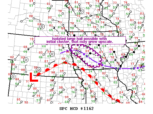
Day 6: Wow, my favorite chase day since 2013! Waking up in the morning, I didn’t have high hopes, mostly because the previous day was pretty tame and the models looked only a little better to me, but as the morning runs came out, things improved. First order of business was to decide between a Texas Panhandle play down near Childress, or a “La Junta Low” setup just west of our starting point of Garden City, KS. Each model run progressively backed off the Childress play, but developed an isolated supercell out in front of a line of storms that developed and moved into Kansas. Turns out the model knew what it was talking about. We headed west…

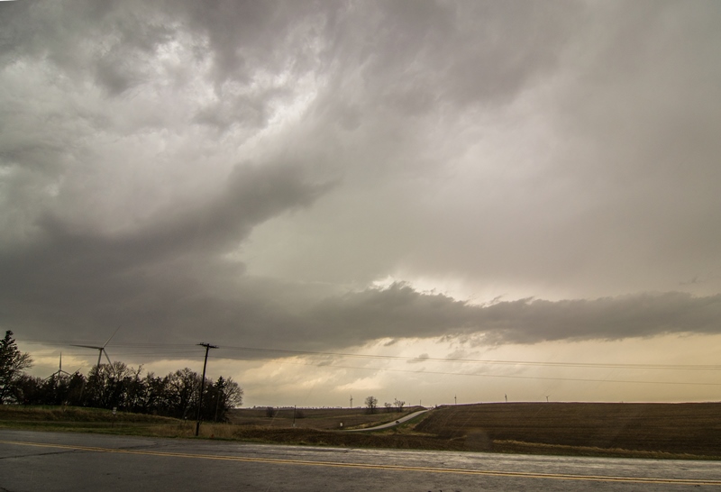
We retraced our steps from the previous day in reverse and headed for Lamar. Right away, things were different than the previous few days: It was actually warm and sunny out! Well, in the 70’s at least. The day wasted no time getting going either, as by the time we stopped for gas in Lamar at about 1:30 Mountain time, storms were firing over the Raton Mesa and heading north-northeast towards us. We headed south out of Lamar towards Springfield as the storms intensified, and were presented with numerous options: one storm well to the west that looked the best near Trinidad, another just west of Pritchett, and a 3rd just west of Boise City, OK. In order to place ourselves in a position to intercept any of them, we headed to Pritchett, stopping just north of town, where we waited to see which storm would become dominant.

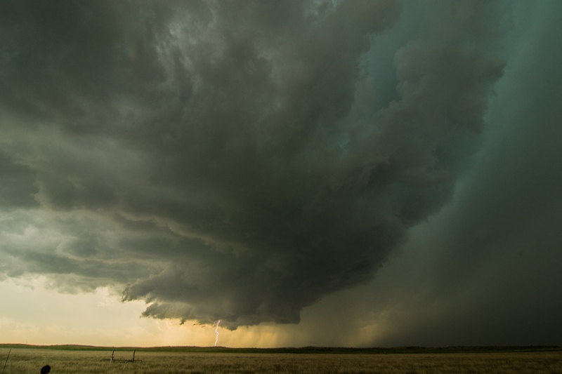
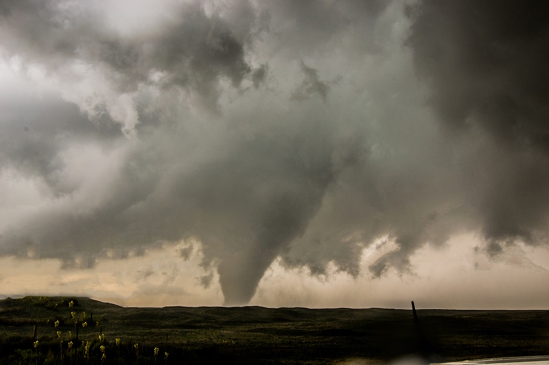
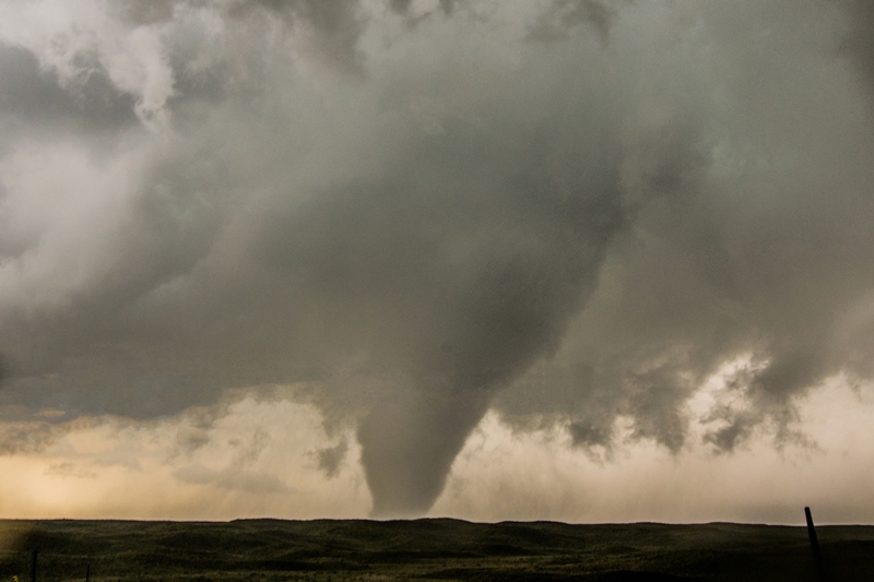
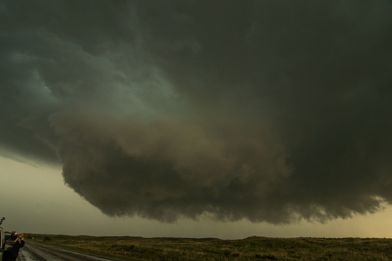
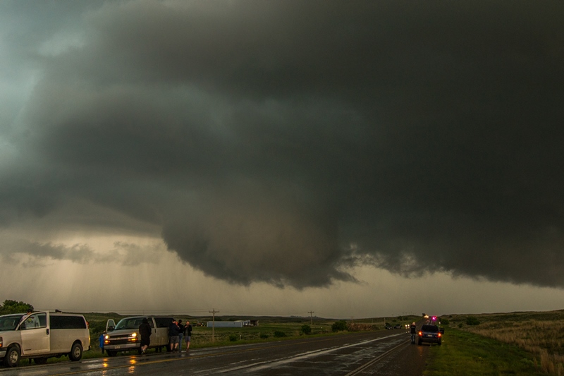
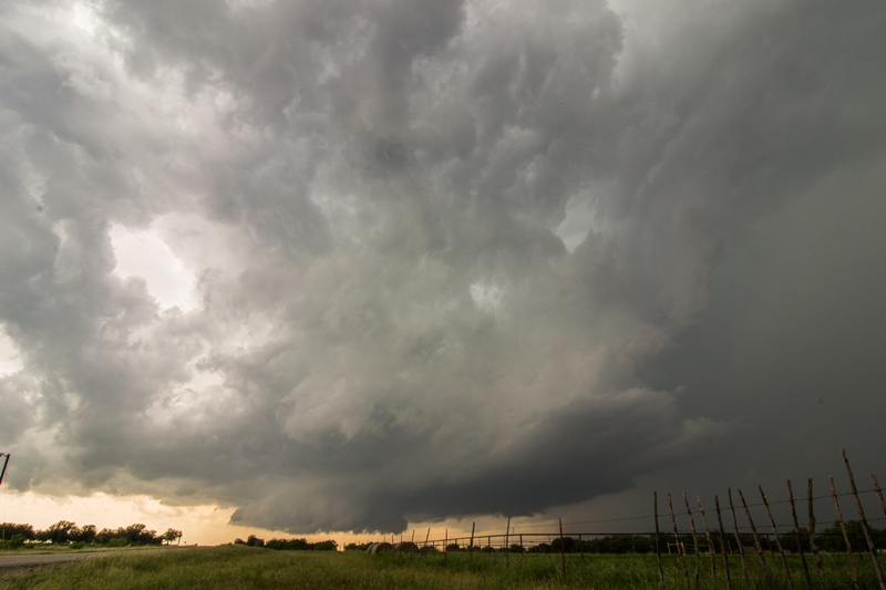
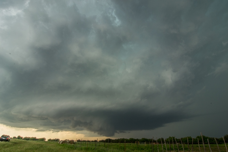
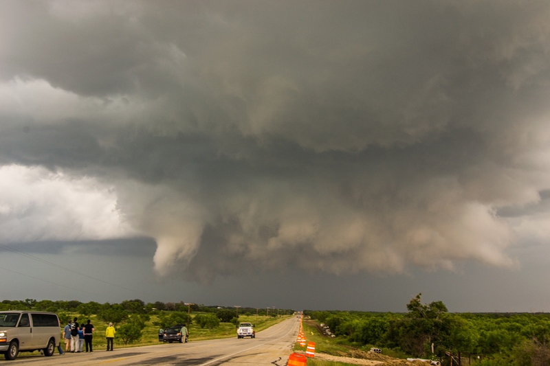
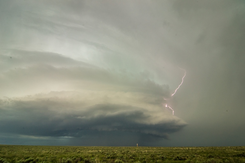
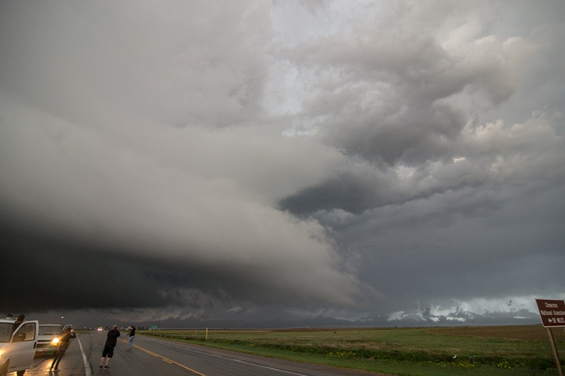
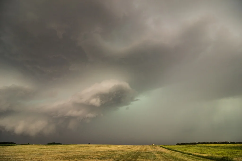
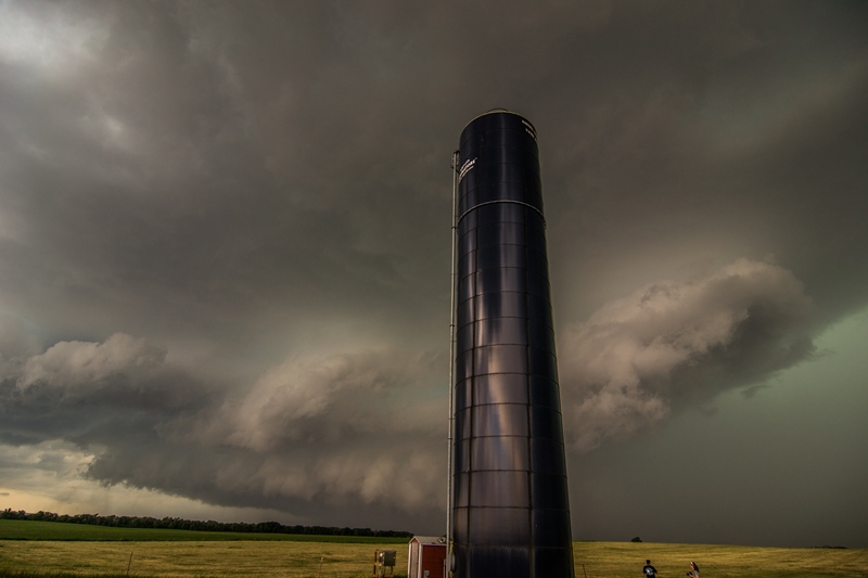
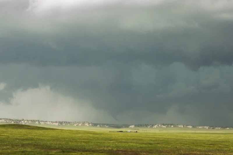
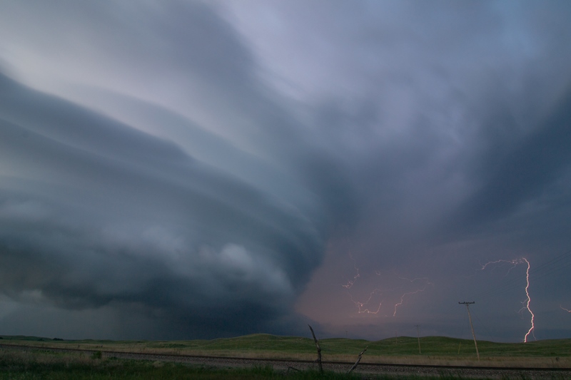
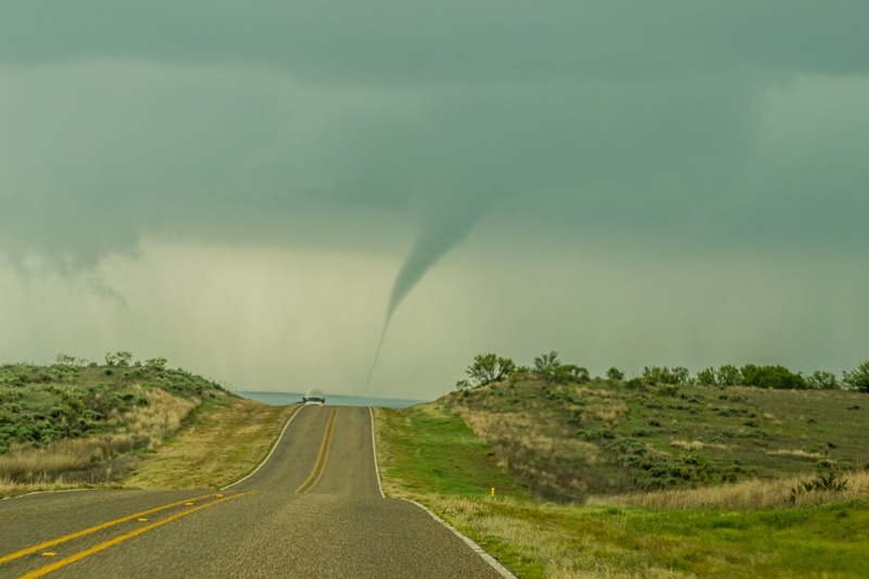
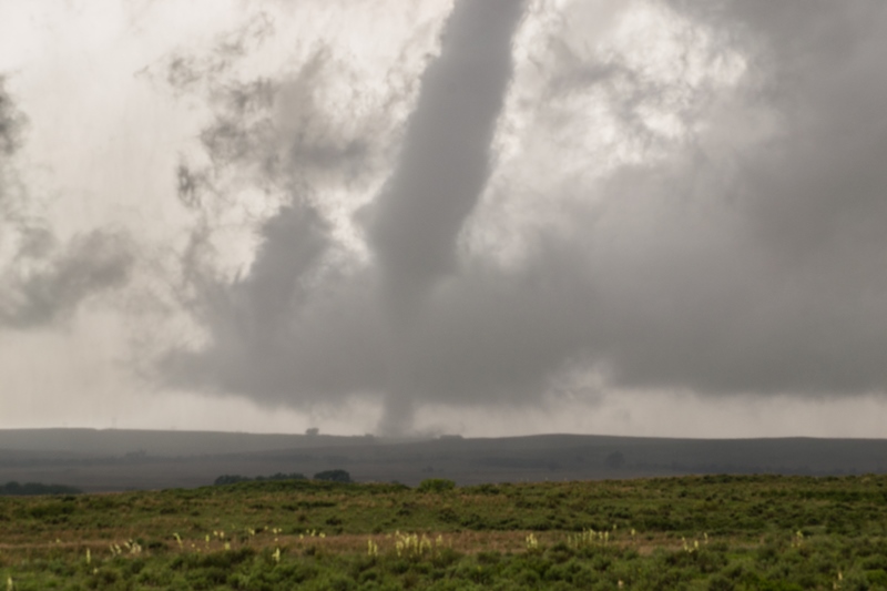
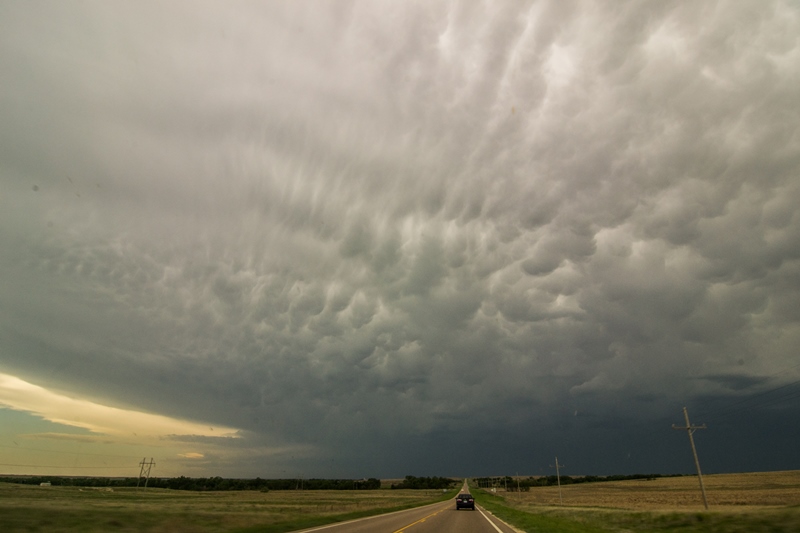
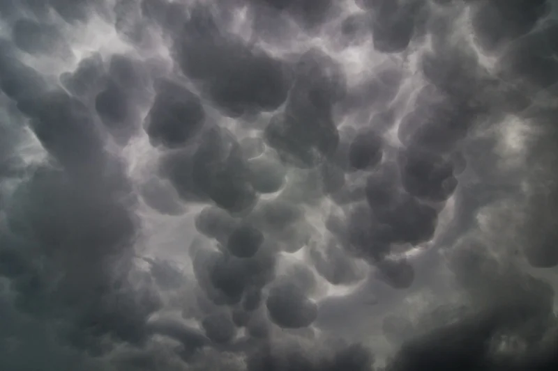
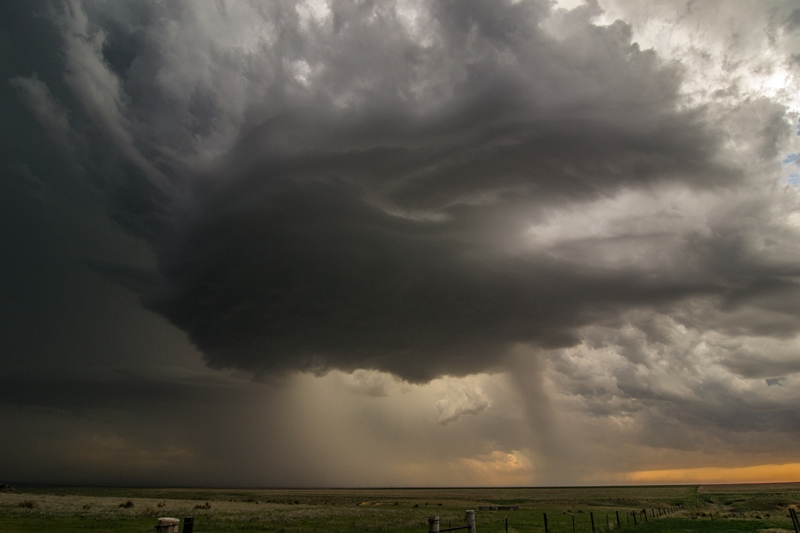
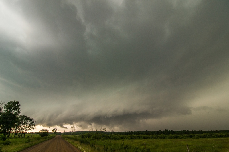
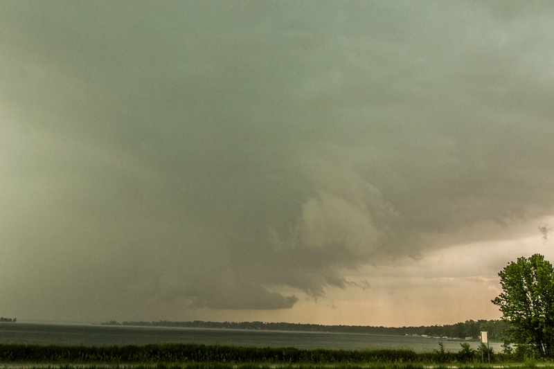
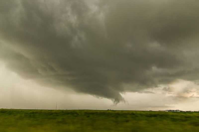
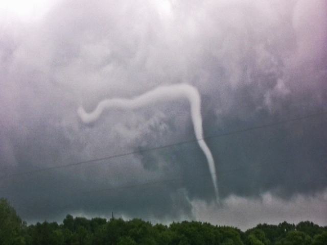
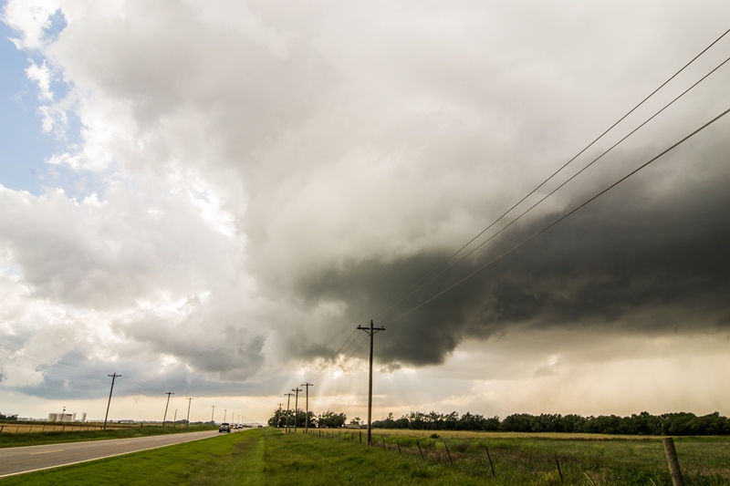
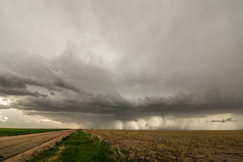
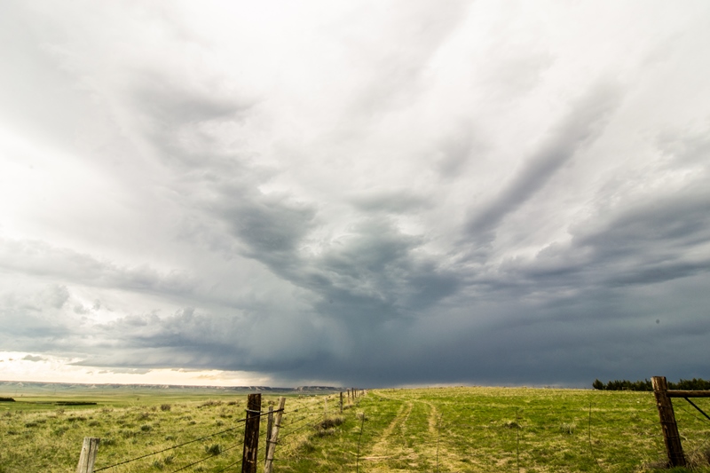
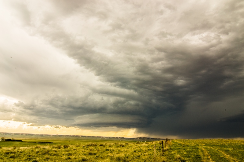
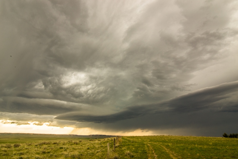
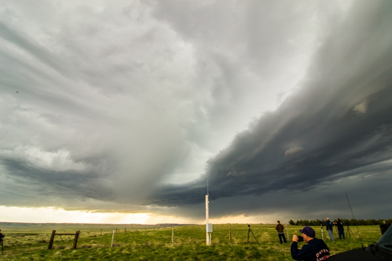
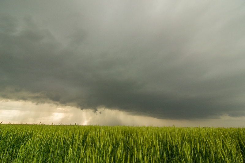
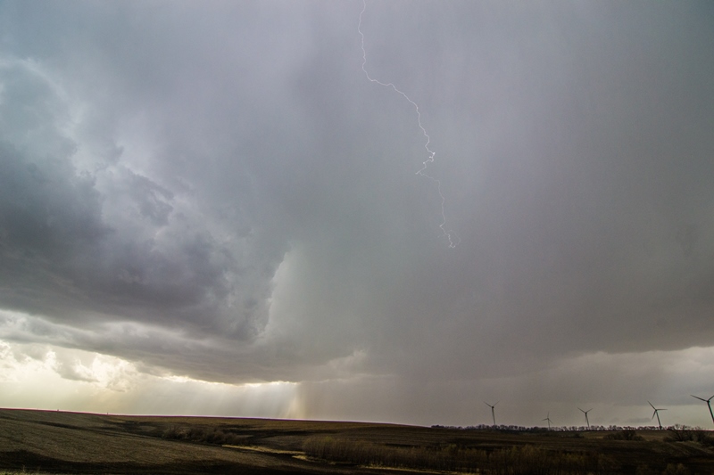
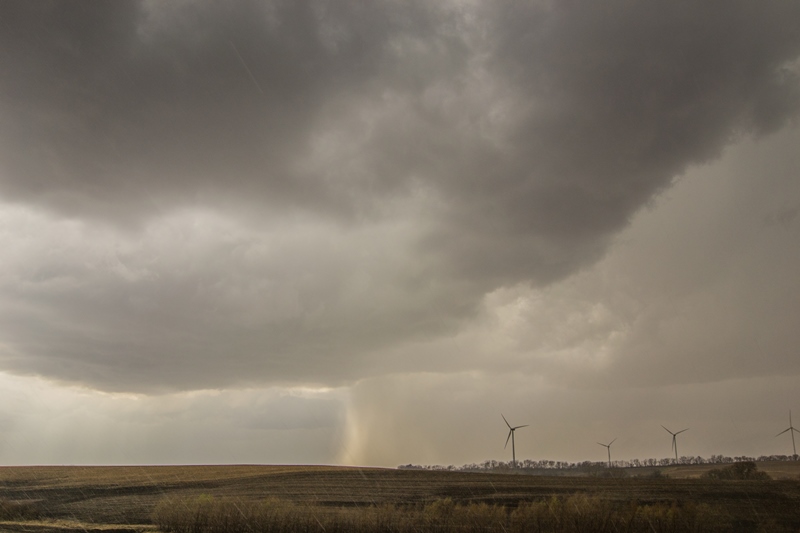
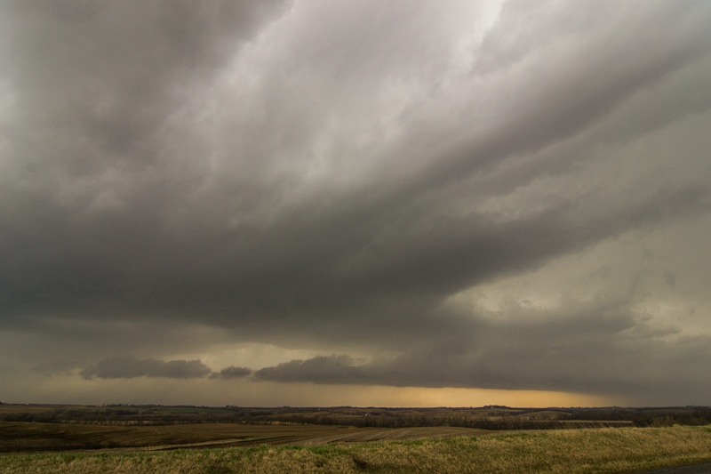
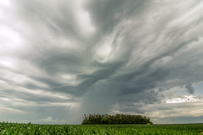
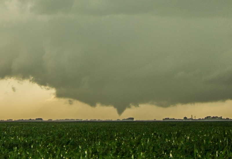
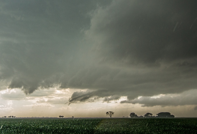
We weren’t there for long before the storm just to our north took off and started to develop a hook and soon we had to bolt back north to get back to it. We headed back towards Lamar and stopped at a rest area about halfway there to take some photos and watch the storm develop. There were actually two cells, and the one in front developed a lowering that was most of the way to the ground while the second one intensified. We headed farther north toward Lamar and by now the storm was a full blown rotating supercell with tremendous structure and that turquoise hue that tells you the hail inside means business. The storm was terrifically striated under a corkscrew updraft, with mammatus and a blocky lowering that was spinning wildly. The storm wrapped up hard and the wall cloud became partially obscured by rain, but soon a cone tornado peaked out (with a little help from contrast-enhancement) and persisted for a minute or two before getting engulfed in the rain again! Tornado #3 for the trip. We watched the storm for as long as we could before the hail core, with baseball-sized stones being reported (and we saw a car with its back window blown out as supporting evidence) threatened to cut our north option off, so we moved out into Lamar and then east towards Granada. The structure as we headed east on Rt. 50 was phenomenal! The storm was now a big striated HP supercell, right turning hard east towards us. We headed south on a dirt road out of Grenada and watched as the storm approached, with a long, linear looking laminar updraft and a wall cloud on the nose end. The rotation of the updraft above us was impressive and the storm was now too big to capture without a wide-angled lens. We were in danger of getting stuck on a muddy road as the storm closed on Grenada and soon the tornado sirens in the town were going off and we headed east on Rt. 50 again to Holly, and then south on Rt. 89.

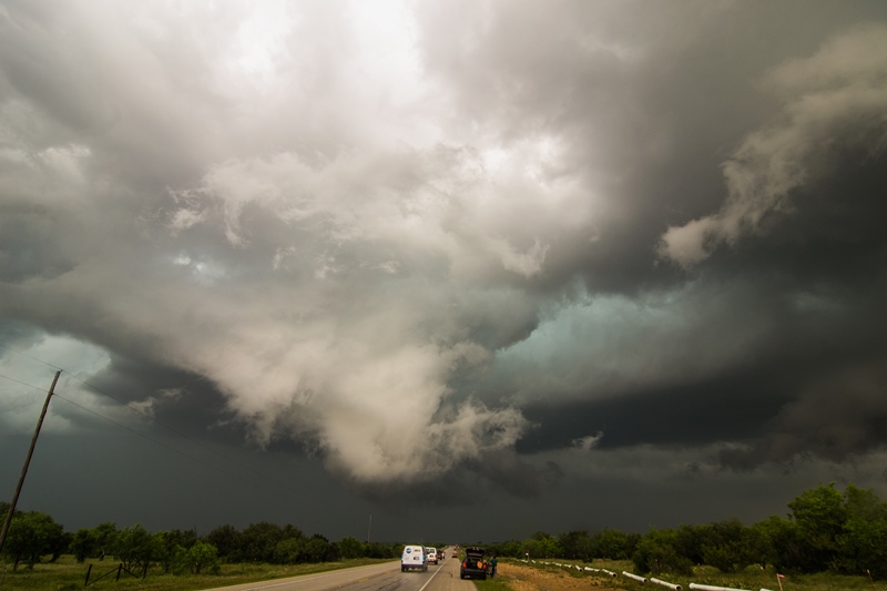
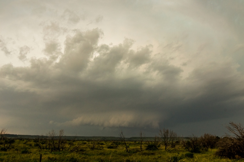
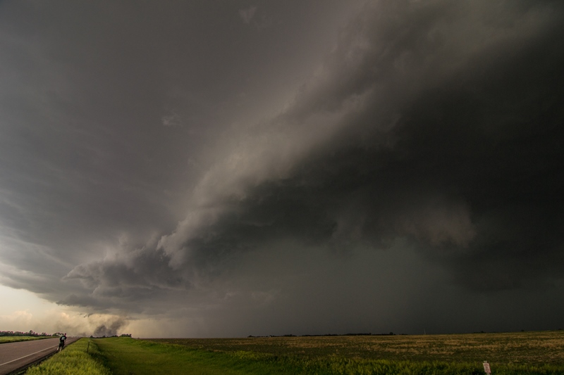
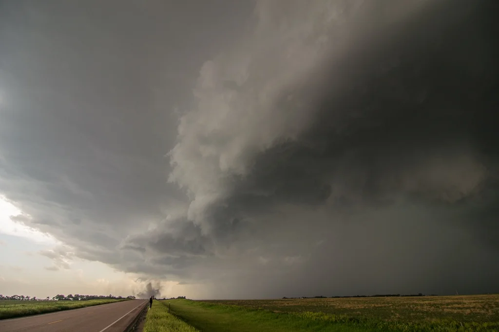
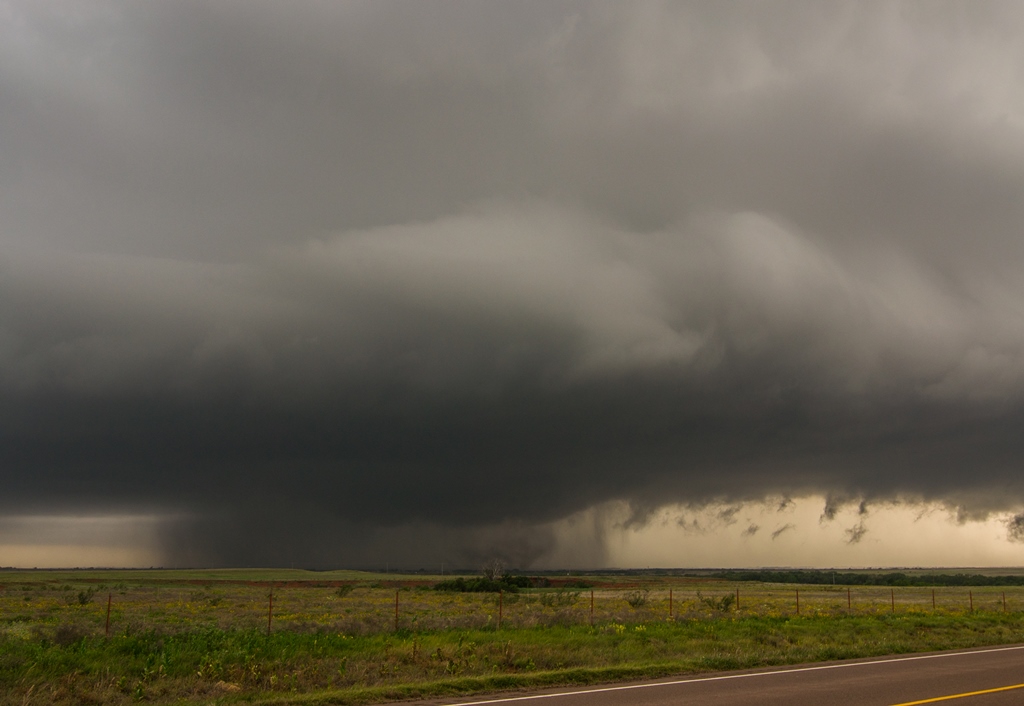
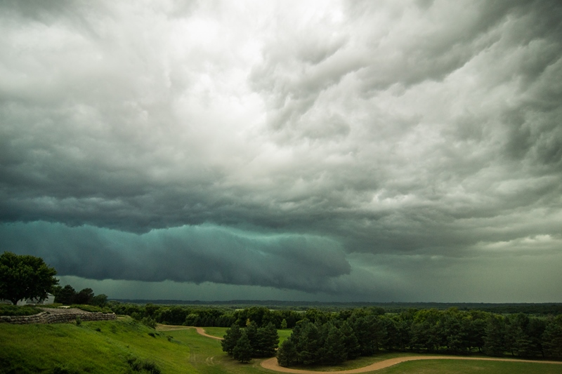
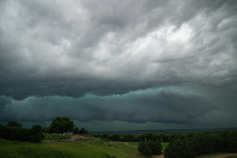
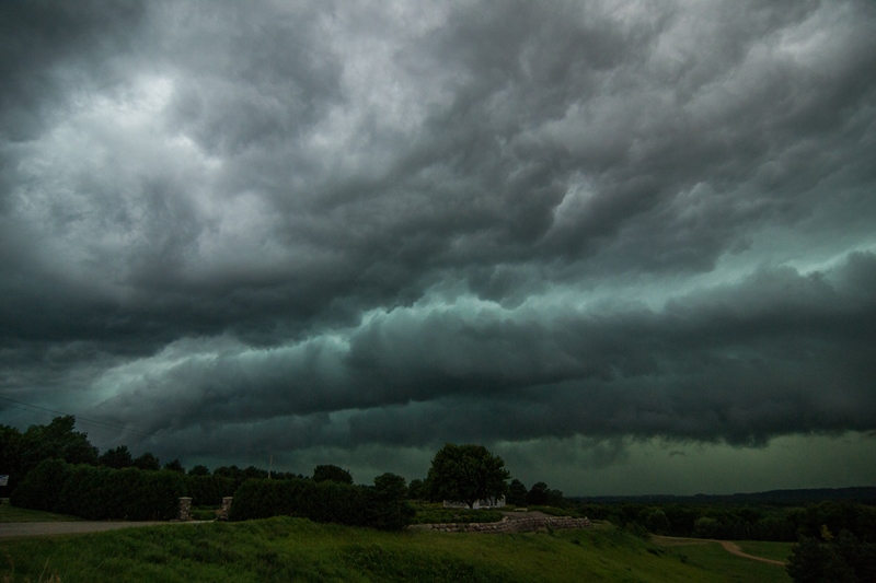
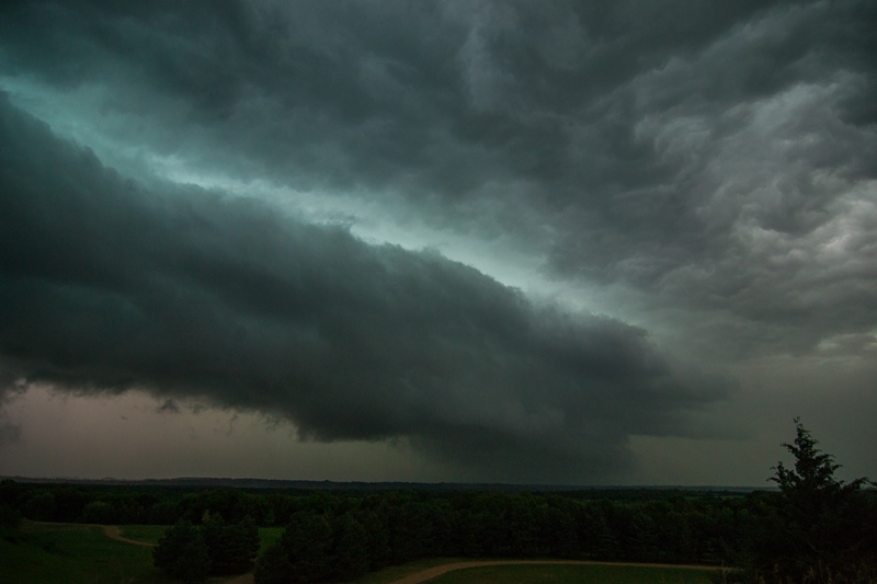
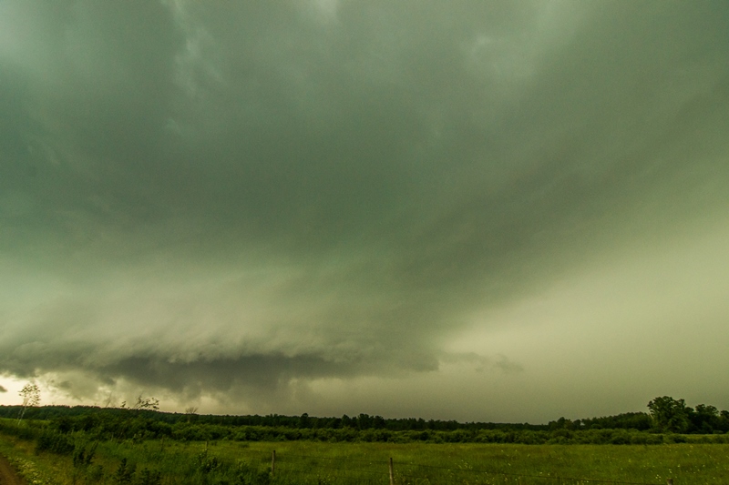
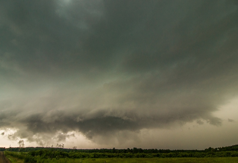
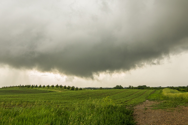
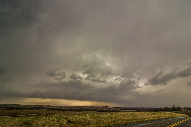
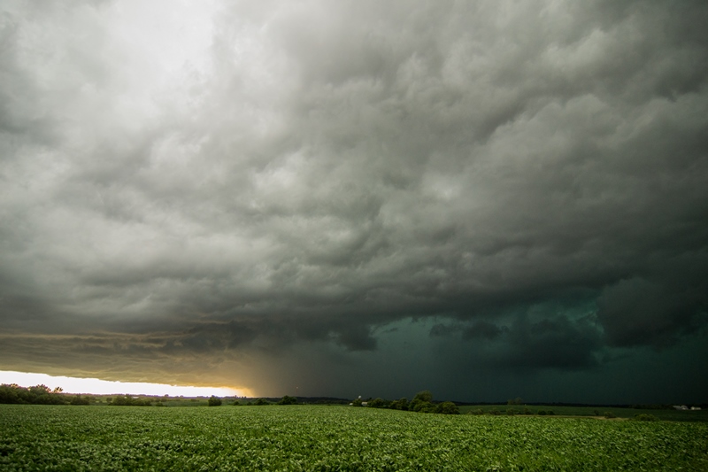
South of Holly, the storm now had a long, linear base trailing off the supercell to the north as multiple cells were now brewing up and the system was becoming a line, but the structure at the north end now had a flying saucer look to it and was still spinning hard. We spend a good half hour watching the storm approach and take pictures, but soon the shelf cloud was practically on top of us and we had to blast south to get out of the way. Another 5 minutes and we would have been pummeled as we stayed there a bit too long. The south end of the line was now taking over anyway and was soon tornado warned, though there was not the slightest sign of rotation in the storm. We narrowly beat the line to Rt. 116, though at this point the line was so thin that you could actually see through to the other side. We headed east into Kansas to stay ahead of the storms.

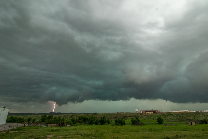
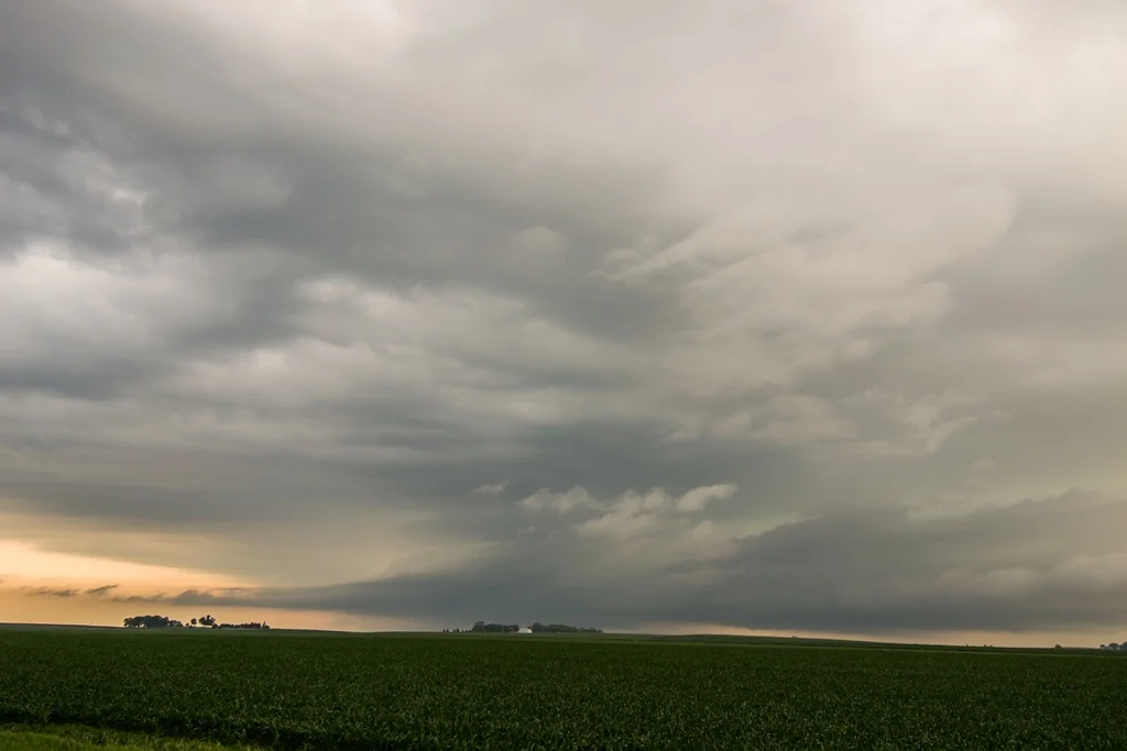
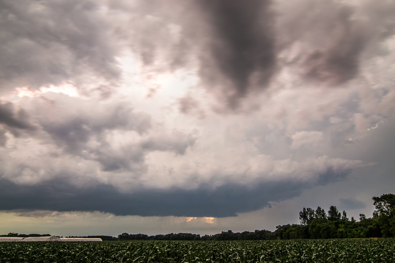
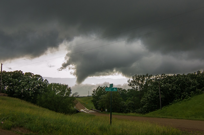
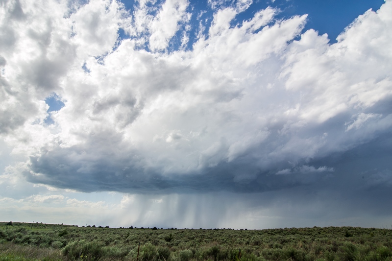
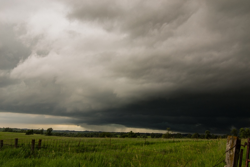
As we headed east, we saw an atomic bomb of convection off to the southwest near Liberal, KS, with a mammoth overshooting top and big back sheared anvil. Once we saw that monster forming, we quickly forgot about the line behind us and bee-lined for the storm, which was already forming a hook. We zoomed through Johnson on Rt. 160 and could see off in the distance the lowered base of the storm that looked to already have a wall cloud developing on it. We had to make a decision: Do we keep going east to get out in front of it, but that would take a long time and while we were passing in front of the precipitation core we would not be able to see what was happening to the wall cloud, or do we head south towards Hugoton and approach the storm from behind, risking being forced to core punch to get to the storm. As we got to Ulysses, we chose the south option since it would get us to the storm quicker and in the worst case if it tornadoed we’d be able to see it, albeit from far away.

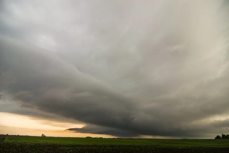
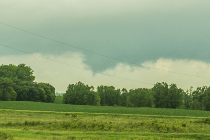
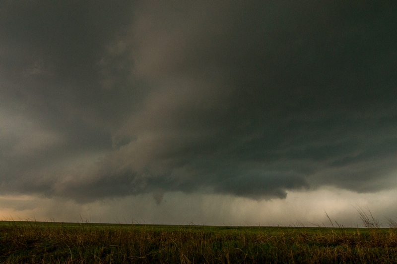
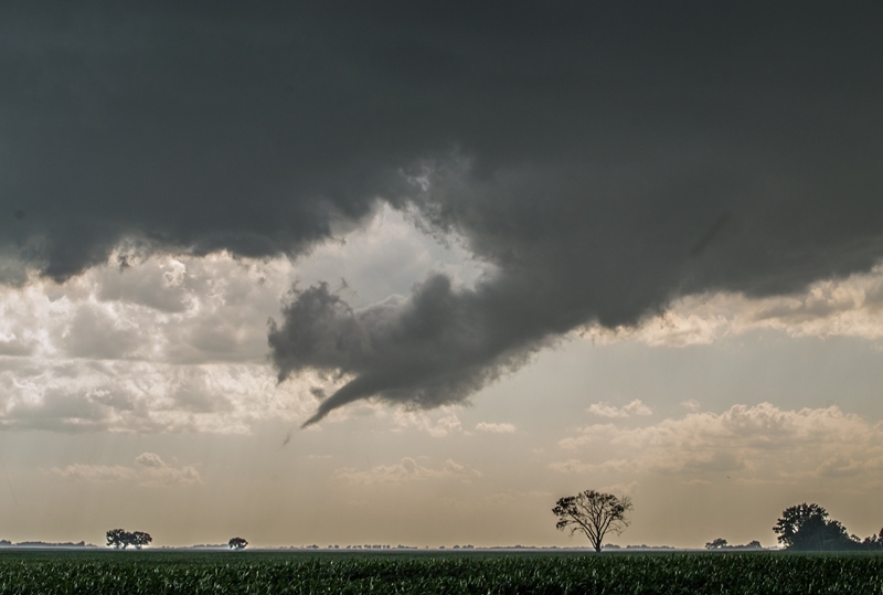
We blasted south along Rt. 25 and got a closer look at the explosive convection going on with the storm. This one was clearly a power house. There were now two distinct lowerings to the south, but then to our east under the updraft of a left-splitting cell there was wild rising motion and an area of white condensation on the group spinning like crazy! The rising motion was almost ridiculously fast, faster than I’ve seen in most tornadoes. The rotation on the group persisted for a minute or so before stopping. Most likely this was a brief anti-cyclonic tornado, but as we could not be sure, we’re not counting it. Meanwhile, off to our west, we had to keep an eye on the robust shelf cloud from the line of storms we’d left as there were a couple of distinct lowering in that line as well.

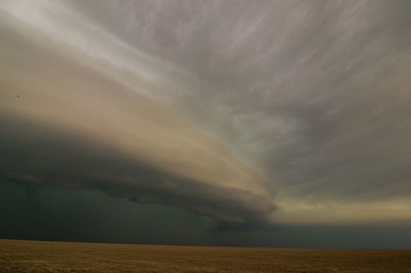
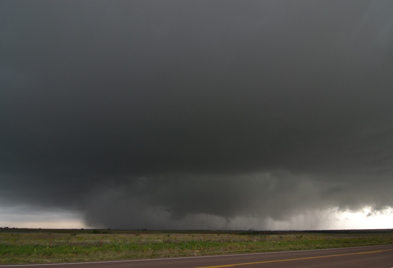
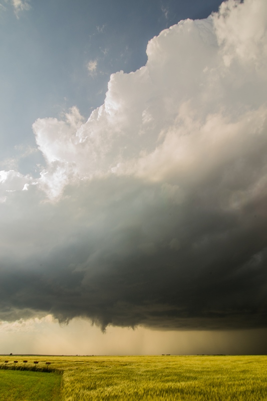
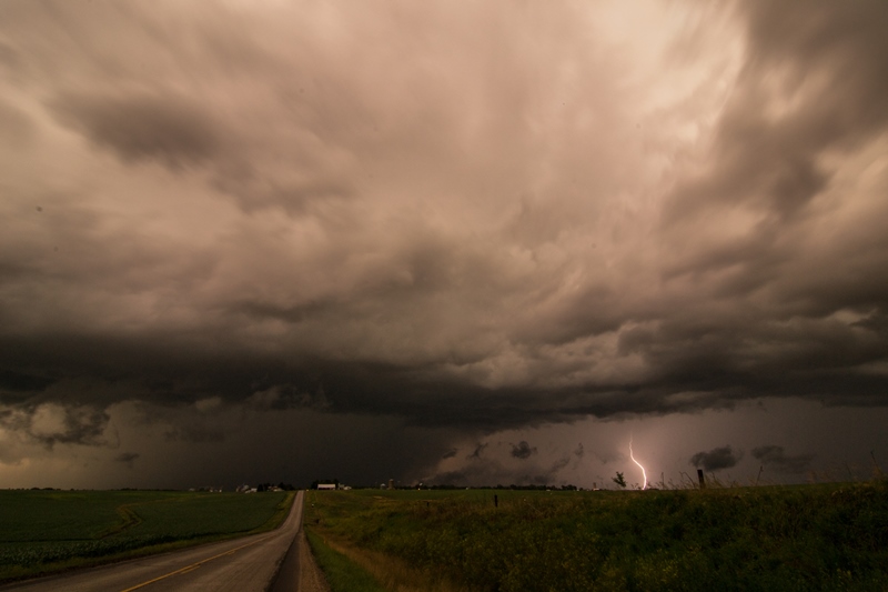
We headed east out of Hugoton on Rt. 51 and were soon coming right up to the two updrafts, one straight to our east and another to the southeast. The structure on the southern cell was fantastic, with a Liberty Bell updraft and a mammatus field under the big back sheared anvil. Both cells had mean looking lowerings and were spinning hard, and as we passed the rear flank of the northern cell just off to our north in the field, the motion was amazing! There looked like there were about 4 areas where we could get a tornado at any time. Time, however, was the problem as it was now getting towards dusk. We got to Rt. 83 and decided to try and get on the southern storm but as we passed by the northern mesocylone we had to stop as it quickly tightened and tried to produce less than half a mile from us! In the near dark it was spooky as the lowering produced several funnels that made it about halfway to the ground that seemed to be getting nearer and nearer to us while inflow screamed into the updraft almost over our heads. We then turned north on Rt. 83 and as the light faded we inched forward on the road with the rotating mesocyclones of the two storms on either side of the van.

Unfortunately at this point it was dark, we would have had to go south and around to get back to the southern storm and with 4 vans in the caravan, chasing at night was not an option. Not to mention we already had a 3 hour drive to Amarillo to look forward to. As we headed south, the storm then went on to produce a massive tornado that lasted over an hour (much of it in the fog!) and traveled nearly 40 miles as the night went on, UGH…Still, this was a GREAT chase day, with 3 storms that were better than any I chased last year. Tremendous structure, one and possibly two brief tornadoes, and some great, adrenaline pumping chase moments.

Total miles for the day: 582