
MAY 16, 2017 TEXAS & OKLAHOMA STORM CHASE: TORNADOES & INCREDIBLE LIGHTNING
This was the day we had been waiting for and the reason for the whole trip. An upper trough was ejecting out into the Plains with strong 55-65 knot winds at 500 mb, amble moisture, instability and strong wind shear to allow for rotating supercells and tornadoes. Wes Hyduke and I left Garden City, Kansas late morning and made our way down to west of McLean, Texas off I-40 to get in position. We encountered 3 separate supercell storms, starting near McLean, Texas and ending near Sentinel, Oklahoma. The McLean storm produced a photogenic tornado, while the storm near Sayre, Oklahoma had a tornado debris spin-up underneath the bowl lowering and mesocyclone. This second storm is the one that brought the big rain-wrapped tornado that led to extensive damage in Elk City, Oklahoma. This was followed by a spectacular cloud-to-ground lightning show near Gotebo, Oklahoma. A great chase day!

Awesome elephant trunk tornado near McLean, Texas. We stopped next to a Doppler on Wheels truck to view the tornado in the distance as it was churning away. This photo is out of sequence with the others below.

Wall cloud on the first tornado warned storm of the day near the Gray County Rest Area, to the west of Alanreed, Texas.

Wall cloud on a second tornado warned storm east of Howardwick and south of Alanreed. Taking on terrific structure at this point with inflow tail on the right into the base and condensating wall cloud. This was the storm that produced the tornado near McLean a short while later.

WE'VE GOT COWS! Had to evade a herd of cattle on dirt road 20 south of Alanreed and northeast of Clarendon, Texas. Was a funny moment when we were trying to get in position to intercept a tornado warned storm heading towards McLean.

Approaching the tornado warned storm southwest of McLean, Texas on highway 273. Wall cloud with large inflow tail right to left into the storm.

Radar grab showing our location close to the time the previous photo was taken.
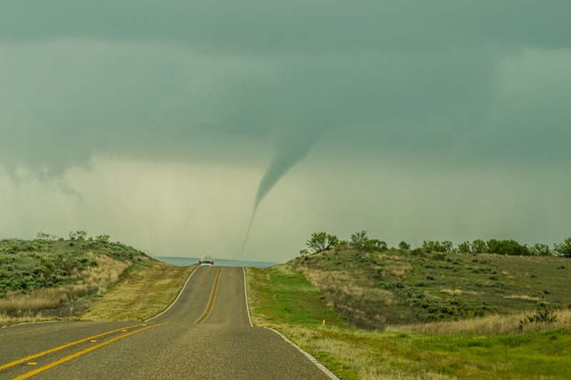
TORNADO! Beautiful elephant trunk to rope tornado south of McLean, Texas as we were driving north on highway 273.

We drove up highway 273 towards McLean and looked off to the left to see the tornado still going strong! I am still not sure if this was a second tornado or in the roping out stage of the first tornado. Could have rotated around the mesocyclone and back west. Appeared to me to be a 2nd tornado on a new updraft off the dryline well to the west of the first tornado, but cannot be sure.
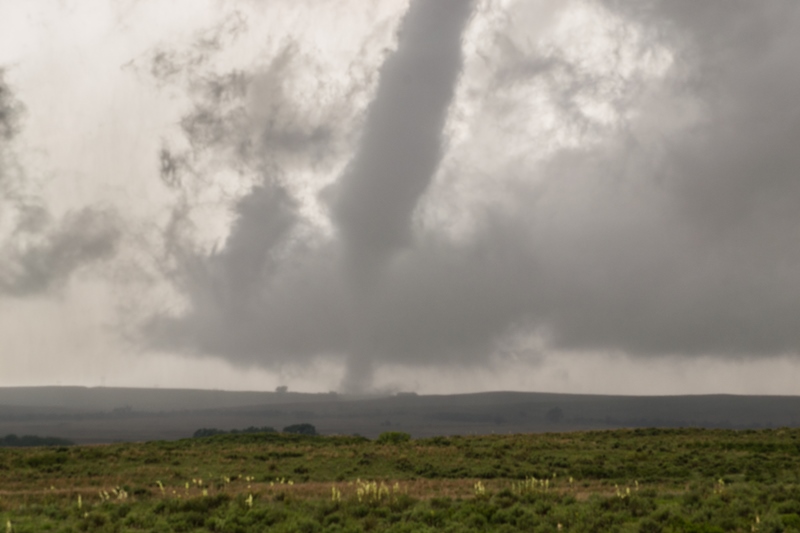
A zoomed in view at the base of the tornado south of McLean, Texas. There was decent rotation at the base of the tornado towards the end of its life cycle but it did not appear to be violent.

Tornado in roping out stage towards the end of its life-cycle.

Rainbow below and exploding supercell updraft as we approached a new storm northeast of Vinson, Oklahoma.

One of the best inflow tails that I have ever seen. This thing was like a conveyor belt of warm, moist air into the storm base and shooting directly into the updraft. Near Sayre, Oklahoma.
Another tornado spinning up dirt directly underneath a fast spinning mesocyclone near Sayre, Oklahoma. A beautiful storm at this point! Thought this was going to drop a big multiple vortex tornado right in front of us, but it never grew beyond this.

Awesome storm structure with beaver tail, wall cloud, quickly rotating mesocyclone and dusty tornado underneath near Sayre, Oklahoma.
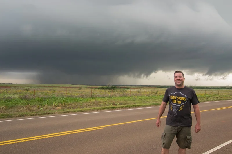
Had to get a photo in front of this storm! It had everything.
A short while later as the mesocyclone was approaching. Still a fast rotating wall cloud, somewhat rain-wrapped, and producing funnel after funnel.

Meso really getting close at this point. Strong rotation and funnel very close to the ground. May have touched down again here but not for certain. Still southeast of Sayre and west of Carter, Oklahoma.

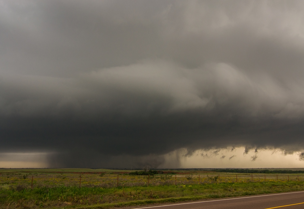
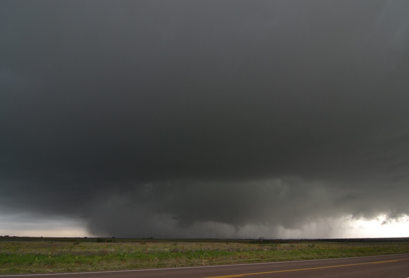
Very close to producing a tornado here. Strongly rotating wall cloud and funnel. This is looking directly into the notch from the northeast side near the forward flank core. Had to get out of here shortly after this photo was taken. The storm later went on to produce a large tornado that hit Elk City, Oklahoma.

Ended the day with a terrific cloud to ground lightning show near Gotebo, Oklahoma.

UNREAL lightning strike that occurred directly in front of our car and right in the middle of my camera frame! Probably will never get a lightning shot even comparable again in my lifetime. Fortunately, I was in the car and had a remote trigger for my camera, which was outside on a tripod. Camera settings were ISO 100, f/22, and 20 second exposure.
STORM PREDICTION CENTER OUTLOOKS


Mesoscale discussion issued at 1:19 PM making note of the tornado watch that will be issued shortly.
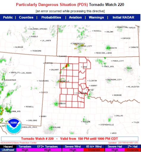
Particularly Dangerous Situation (PDS) tornado watch issues at 1:50 PM until 10:00 PM CDT. Note the high likelihoods for tornadoes, wind and hail.
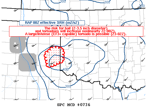
New mesoscale discussion issued at 4:56 PM, highlighting the small area where tornado risk would be greatest as well as extremely large hail. This area highlighted was where the 2 storms in which we saw tornadoes were located.

Another mesoscale discussion issued at 7:29 PM, highlighting a continued tornado risk east of where the current tornado watch was in place.
