
JULY 12TH MINNESOTA: FUNNELS & 2 BRIEF TORNADOES
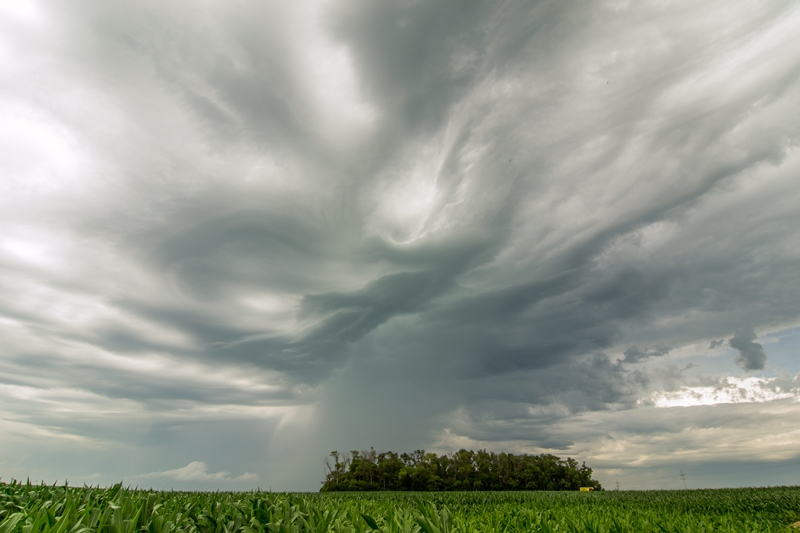
A turbulent sky as elevated storms form north of the warm front over corn fields near Wendell, Minnesota.

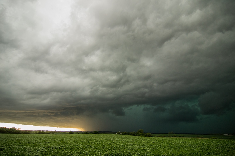
A shelf cloud forming on the storm near Foxhome, Minnesota. Severe warned for mainly hail at this point.

The first tornado touching down in the distance east of Doran, Minnesota as we watched on highway 19.
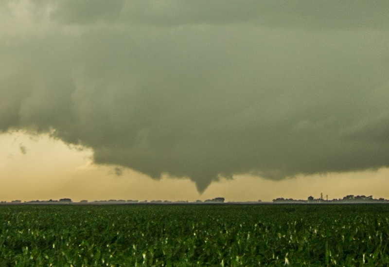
Cropped shot of the photo from above, showing the tornado. Other chasers confirmed this indeed touched down.

Tornado lifted and formed a bowl shaped funnel in the middle of the wall cloud.
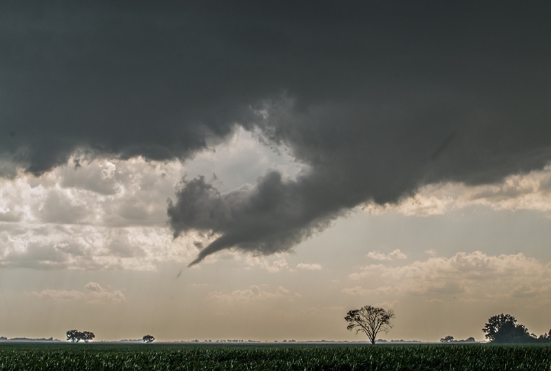
A few minutes later, this rope funnel appeared closer to our location on the lead storm. This was a a few miles north-northeast of Campbell. Thanks Tony for noticing this! We were transfixed on the previous funnel as it was still present at this time to the right.

Elongated funnel cloud north of Campbell, Minnesota.

Beautiful funnel cloud on the storm a short while later!

Funnel wrapped up into a rope as the rear-flank-downdraft outflow started to undercut.
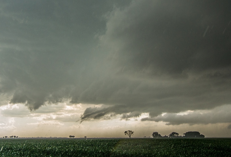
Around the time that this touched down as a tornado. You can see this ground truth in the video.

Good structure on the high precipitation storm.
Intense storm near Barrett, Minnesota.
MESOSCALE DISCUSSION:

STORM REPORTS:

STORM PREDICTION CENTER OUTLOOKS:

JULY 12th, 2015 CHASE LOG: MINNESOTA
It’s not too often that a chase day turns out almost exactly like you thought it would…but this was one of those days! Our group consisting of myself, Wes Hyduke, and Tony Perkins left Burnsville, MN around 12:45pm, heading northwest on I-94 towards west-central Minnesota. My initial target for the day was Tenney.
Storm Setup: A surface low set up just west of the North Dakota/South Dakota/Minnesota border area by the early afternoon with a warm front draped to the east through central Minnesota, and a trough to the south of the low through eastern South Dakota. A mid-level trough was approaching the area from the west, while an extremely unstable environment was in place with dewpoints in the lower to middle 70s and 4,000-4,500 j/kg of MLCAPE. Bulk shear was on the order of 35-45 kts with lower bulk shear north and higher south. Ongoing, elevated convection reinforced the warm front ahead of the surface low into west-central Minnesota.
We traveled to Alexandria for gas and then northwest to Elbow Lake and parked at the intersection of Hwy 59 and Hwy 55 northwest of town. This was an excellent spot to go any direction with good roads. A mesoscale discussion (MD) was issued by the SPC from our location and areas north at 2:54 pm, while a more strongly worded MD was issued at 3:53pm from our location south through all of southwest MN and eastern SD. This new MD highlighted a supercell and tornado risk in this area. A Tornado Watch was issued a short while later.
Storms near Fergus Falls to our north quickly became tornado warned and we drifted towards them, all the while keeping in mind that new storms would likely form to the south of this initial cell. We caught up with a new southwest updraft near Foxhome. The storms to our northeast were tornado-warned but our storm was still developing and was severe-warned at the time. I wasn’t about to go running to the storms northeast of our area that appeared to be north of the warm front and in a more stable airmass, so we stayed put on our storm as new towers developed to the southwest. The storm we were on started to spew cold air and became very outflow dominant with a shelf cloud. We bailed this storm quickly and headed south towards another storm that was really starting to get its act together. Upon core punching a lead cell, we ended up south on Hwy 19 east of Doran. We still hadn’t got out of the rain before noticing a well-defined lowering in the distance that was starting to take on a bowl shape. Stopping to watch, a cone funnel appeared and condensed over halfway to the ground. We later heard that this did indeed touch down, to our watch at 5:05pm. As this funnel was starting to dissipate, Tony noticed a beautiful rope funnel just to our southwest on our lead cell! This was the highlight of the chase as the rope twisted and turned for several minutes, changing shapes and growing/shrinking throughout. As you can see in the video, this rope did touch down as it became undercut by the storm outflow as we watched northeast of Campbell. This was at 5:15pm.
The chase continued through Nashua, Wendell, and Elbow Lake to the east and then down towards Barrett and Hoffman. Upon the way, we saw some okay structure, well defined inflow bands, and some ragged lowerings that did not appear to be doing much. This was more of a monster hailer and wind-maker more than anything at this point. Upon chasing this storm east of Hoffman, we decided to call it a day as the storms were congealing into a line. Driving south on I-94, we stopped for dinner, barely making it out of Sauk Centre before getting cored by the severe line.