May 24th Southern South Dakota and Northern Nebraska Storm Chase - Supercell Storm and Mammatus

05-24-10 CHASE LOG:  SD/NE

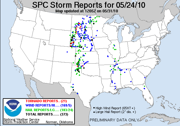
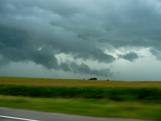
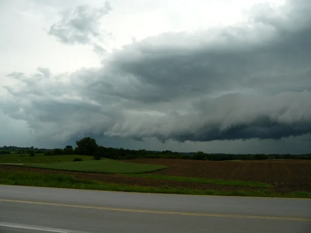
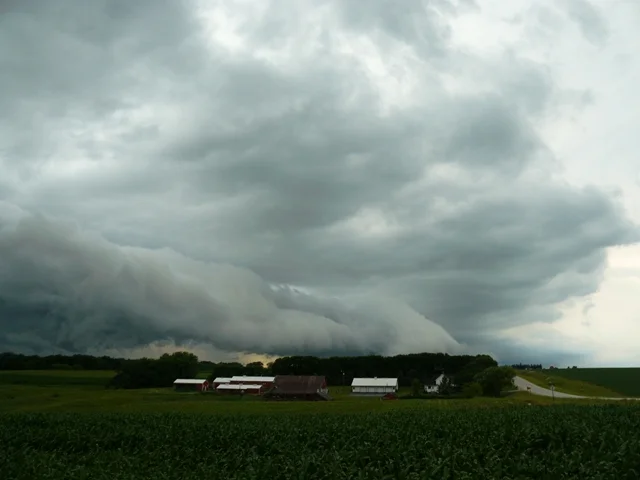
  This was a difficult chase day with a strong storm system and fast moving storms in a large Moderate Risk for severe storms.A low pressure system was forecast to progress from western SD into southwest ND during the day with a warm front quickly lifting northward from near I-90 to the SD/ND border by evening.A dryline and cold front were expected to move into western SD and western NE through the day.After several long chases in a row, our group decided to meet by late morning in Valentine, NE and then head north on Hwy 83 to Murdo, SD.Storms already began to fire around midday ahead of the triple point near Rapid City, SD and additional storms began to fire on the warm front lifting north of I-90.Storms all day were moving at nearly 55-65 mph on average so anything that got by us was long gone.We decided to attempt to intercept a tornado warned storm near Rapid City, but soon realized that a storm ahead of the triple point on the warm front would be the storm of the day.This was our original plan was to play any storms in this area but, due to the late start in the day, we could not get to this storm in time to see the large tornado it did produce near Faith, SD.More storms began to fire in the warm sector in a highly sheared,unstable, and moist environment in central NE and move north towards our area, so we ended up bailing on the cell near Rapid City and turning around in Wall, SD and traveling back to Murdo, SD.Just east of here is where we intercepted our first storm of the day near Draper.This storm was severe and had nice structure and actually a nice rotating wall cloud for quite a while.Other storms were firing to the south into the early evening, while the storm we were on was not looking overly impressive so we ended up heading back south on Hwy 83 back towards Valentine, NE and intercepting a squall line about 20 miles north of town. This line had a messy shelf cloud, some gusty winds, and heavy rain, but nothing that was all too impressive.

p1040390-3
p1040390-3

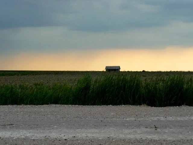
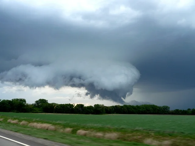
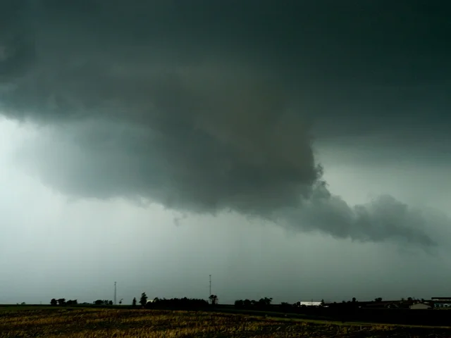
Storm with lowering near Draper, SD.

p1040404-3
p1040404-3

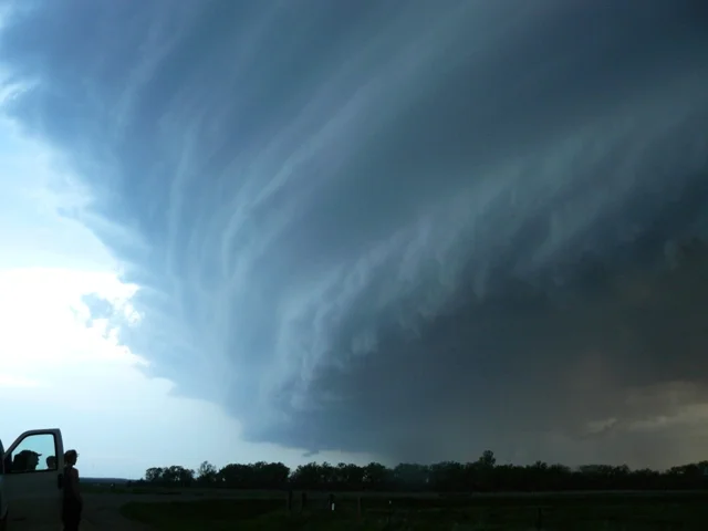
Storm with rotating wall cloud near Draper, SD.

p1040405-3
p1040405-3

Incredible mammatus in Valentine, NE.

p1040406-3
p1040406-3

Mammatus in Valentine, NE.

p1040407-3
p1040407-3

More mammatus at sunset in Valentine, NE.

More photos from this day can be found here:http://www.flickr.com/photos/39991047@N02/sets/72157624218639078/

Storm Reports:

100524_rpts
100524_rpts

May 23rd Northwest Kansas Storm Chase - 3 Tornadoes Including a Nighttime Tornado Near Goodland


05-23-10 CHASE LOG:  KS

After an incredible chase the day before where we witnessed the Bowdle wedge tornado and 5 other tornadoes, our tired crew left Winner, SD early this morning and targeted northwest KS in a Slight Risk for severe thunderstorms per SPC.There was an area of low pressure that was expected to develop across northeast CO with a trailing dryline through eastern CO and a stalled boundary across northeast CO into southern NE.With a stout cap, thunderstorms took until nearly early evening to initiate and then took until sunset and after to mature.We targeted storms along the triple point but, as a few storms started to develop further south along the dryline, these storms began to rotate and soon became tornado warned.Our route was to progress west from Oakley, KS on Hwy 40 and then north on Hwy 27 as storms moved nearly due north, paralleling Hwy 27 towards Goodland.Two short-lived rope tornadoes did touch down right at sunset to the southwest of Goodland to the west of Hwy 27.However, the most significant tornado touched down 9 miles NNE of Goodland.This tornado was what appeared to be a rather strong, cone tornado that was visible through the occasional lightning.This tornado appeared for around a minute and then disappeared.Our course then took us north to Hwy 36 east where we took some lightning shots near Bird City. I cannot be disappointed with this day with 3 tornadoes and a pair of nicely structured supercell storms!

p1040349-3
p1040349-3

Storm first going up with abondoned shed in the foreground.

p1040353-3
p1040353-3

First funnel of the day!

p1040356-3
p1040356-3

Incredible storm structure on the LP storm near Sharon Springs, KS.

p1040366-3
p1040366-3

Wall cloud dragging on the ground on the tornado warned storm near Goodland, KS.  Shortly after this produced two different, weak spin-ups.

p1040379-3
p1040379-3

Storm being lit up by lightning near Bird City, KS.

More photos from this day can be found here:  http://www.flickr.com/photos/39991047@N02/sets/72157624088058263/

Storm Reports:

100523_rpts
100523_rpts

May 21st Wyoming and Nebraska Storm Chase - One Tornado and a Funnel


05-21-10 CHASE LOG:  WY/NE

The target this day was in the upslope regimen of the Cheyenne Ridge through southeast WY with storms expected to develop in the mountains and move out into the High Plains area during the mid to late afternoon.Our group left Colby, KS in the morning and progressed northwest to Cheyenne and then north on I-25 toward Chugwater, WY as a pair of intense storms were already firing on the Laramie Range and about to move off the mountains into the open High Plains.Consequently, this is where the better environment was at with moderately strong heating indicated by SB CAPE values in the 1500-2500 j/kg range, dewpoints adequately into the upper 50’s in a higher elevation area, and strong east-southeast winds at 20-30 kts which led to strong inflow and low level shear.In addition, these storms developed in an area of higher bulk/deep layer shear values of 40-50 kts and could have been higher with a shortwave moving through the region and helping to ignite convection.

Upon approaching the storm near Chugwater, it quickly produced a short-lived rope tornado that we did see from 15 miles south of the storm.This tornado touched down near Wheatland, WY.Being so far away from the storm at the time of the tornado, we were not positive that it touched down after seeing the funnel ¾ of the way to the ground, but confirmation came from spotters and chasers in that area that it did indeed touch down around 5pm.The tornado dissipated as we followed to the south of the storm on Hwy 316 and then north in Hwy 160 towards Fort Laramie, WY as the storm continued to right turn and actually take a more east-southeast movement.A couple of rotating wall clouds were seen along the storm path, as well as a very interesting lowering on the left split storm to the north of ours that did end up becoming tornado warned.Our storm ended up moving out into an area with no roads upon crossing the WY/NE border so we ended up going north on Hwy 85 towards Lusk, WY and then east on Hwy 20 where we intercepted again near sunset in Crawford, NE.We witnessed a spectacular lightning show before ending the chase here and traveling to Valentine, NE for the night.

p1040227-3
p1040227-3

Tough to see, but this is the tail end of the tornado way in the distance near Wheatland, WY.

p1040229-3
p1040229-3

Lowering underneath a new updraft on the storm near Wheatland, WY.

p1040230-3
p1040230-3

Another storm coming off of the Laramie Range in WY.

p1040232-3
p1040232-3

Two new explosive updrafts on our storm east of Wheatland, WY.

p1040241-3
p1040241-3

Horizontal funnel forming on the leading edge of the RFD clear slot.

More photos from this day can be found here:  http://www.flickr.com/photos/39991047@N02/sets/72157624087897675/

Storm Reports:

100521_rpts
100521_rpts

May 19th Oklahoma Storm Chase - 3 Tornadoes from a Long Lived Tornadic Supercell


05-19-10 CHASE LOG:  OK

This ended up being by far the worst chaser convergence I have every experienced and a rather stressful day, although we did see several funnels as well as a terrific rain wrapped tornado near Dover, OK.I was chasing for Silver Lining Tours and this was our Day 2 after seeing 4 tornadoes on day 1 of the tour.We woke up in Amarillo, TX to a moderate risk across much of OK and, while traveling east to our target area, the Storm Prediction Center upgraded to a High Risk for the potential for a severe weather and tornado outbreak.An MCS had gone through during the overnight and dropped an outflow boundary that intersected the warm front from northwest to southeast across OK.This likely helped to enhance the low level shear along the boundary.A surface low was forecast to move into northwest OK during the afternoon with a dryline mixing east into western portions of the state as well.Extreme instability of 2500-3500 j/kg and strong low and deep layer shear was forecast to develop ahead of the dryline and along the warm front during the afternoon on the 19th.The idea was to wait in Clinton, OK and wait for initiation either on the triple point, warm front, and/or dryline.There were also upper 60’s and lower 70’s dewpoints feeding into this area so moisture was a big bonus.

The triple point produced the first storm of the day shortly before 3pm and we waited for a half hour in Clinton until we were sure this would be the storm to go after.More towers were going up on the warm front and dryline and they were sure to fire soon, but the storm that was now west of Leedey, OK was really starting to look terrific so we took off after that north on Hwy 183 and west on Hwy 47.The storm produced a brief tornado near Leedey, before we got on it, but we did manage to see the tail end of the tornado from around 6-8 miles away as it was lifting.This storm had intense, new updrafts going up on the flanking line to the southwest of the storm with several nice wall clouds as each updraft went up.

The supercell was drifting to the east at 15-20 mph but it quickly became apparent that chaser convergence was going to be a major issue as this storm was continuing to progress into a more favorable environment and was the best storm anywhere in the country.Hundreds of chasers converged on this cell and Hwy 33 from Watonga to Kingfisher became a mess of chasers battling for position while trying to stay out of each other’s way.The storm kept recycling wall clouds and several funnels were noted on the route as we attempted to stay ahead of the storm.Near Watonga, the storm produced a rapidly rotating mesocyclone and we were barely able to stay head of a developing tornado at that time.Upon moving towards Kingfisher, we decided to travel north on Cty Rd 2740 and then east on Cty Rd 720, just ahead of the hook on radar and clearly in the notch as the hail core began to wrap around with the rear flank downdraft.Approaching the Dover area, the storm dropped a rain wrapped, cone tornado only around a half mile from the road which is seen in the photos below.We attempted to stay ahead of the tornado and wanted to drop south and get ahead of it, but were blocked by other chase vehicles and the tornado managed to cross the road directly in front of us and then off into a field very close to our position.The tornado was rain wrapped but I did get some short video of it at that time.In addition, this tornado did reportedly produce some damage to a farmstead in this area.

p1040207-3
p1040207-3

Lowering underneath the updraft of the storm north of Aledo, OK.

p1040210-3
p1040210-3

Intense, new updraft on the storm as we first got on it north of Aledo, OK.

p1040212-3
p1040212-3

Rain wrapped cone tornado!

p1040213-3
p1040213-3

Another shot of the tornado near Dover, OK.  This thing almost ran us over due to other chasers blocking the road in front of us!

p1040217-3
p1040217-3

Edge of the mesocyclone of the supercell.

p1040219-3
p1040219-3

Another storm going up well to the south at sunset.

More photos can be found here:  http://www.flickr.com/photos/39991047@N02/sets/72157624106808676

Storm Reports:

100519_rpts
100519_rpts

May 22nd South Dakota Storm Chase - The Bowdle EF4 Wedge Tornado


05-22-10 CHASE LOG:  SD

This chase definitely tied with June 24th, 2003 as the best chase of my life!  We started the day in Valentine, NE after chasing and seeing a brief tornado in eastern WY the day before.  There was an area of low pressure that was progressing towards central ND with another low that was expected to reach central SD by late afternoon.  Ahead of this low a warm front stretched from near Pierre, SD down into southeast portions of the state and was slowly lifting northward through the afternoon, as a cold front south of the low slowly worked eastward as well.  The idea was to play the triple point near these boundary intersections as models had continued to develop storms ahead of this feature and some held off storms till evening further south where a stout cap was in place, per the special 20Z observed sounding out of Aberdeen that indicated +18 deg C at near 800 mb.  There must have been an amazing amount of forcing and convergence on the triple point, because several towers developed by late afternoon and a big storm broke through to the west of Akaska, while we were positioned to the southeast near Gettysburg.  This was an incredible environment for this storm to go up in as dewpoints ranged from the upper 60’s into the lower 70’s and even a few 74 degree dewpoints pooling along the warm front and triple point.  In addition, it was very unstable with a nose of 4000-6000 j/kg of SB CAPE poking up into the region in a strongly sheared environment due to the southeast winds near 20 kts and some locations gusting over 25 kts at times.  The dry punch into the region from the southwest, as indicated by the drop in dewpoints, likely helped convergence as well and possibly a forecast shortwave that was forecast to move into central SD at the time storms initiated.

The storm quickly became tornado warned near Lowry and produced a lowering with rotation soon after.  The first tornado of the day dropped northeast of Lowry as a stovepipe and then became an elephant trunk and appeared to weaken.  However, the circulation gained intensity upon moving close to us on Hwy 47 and we quickly moved north to stay ahead of this tornado.  The tornado crossed Hwy 47 and Hwy 12 shortly after we had moved east and observed the tornado at close range to the road.  This is where the tornado downed powerlines and poles, blocking the road from anyone wanting to travel east and stay with the tornado.  As we moved towards Bowdle, our plan was to head north on Hwy 47 and observe this tornado that was holding together.It quickly grew into a wedge tornado to the northwest of Bowdle and we were able to experience this mammoth beast at close range as the track continued to take it to the east-northeast.  About 1 mile west of Hwy 47 is where the wedge, unfortunately, appeared to hit a couple of farmsteads and one of the families was in their vehicle right next to ours, watching their home get destroyed.  It was a sad moment as we tried to console them over their eventual loss.

At this point, we became cut off from heading north and needed to head back on Hwy 47 back towards Bowdle and through the RFD winds that were very strong just north of town.  We then traveled east on Hwy 12, observing a second tornado near Roscoe and then 3 more weak elephant trunks northwest and then 4-5 miles north of Ipswich.  Here is where the storm became very HP and we bailed south on another tornado warned storm near Faulkton where we witnessed incredible storm structure and a couple of funnels that could not quite make it to the ground.  What an amazing chase day and one I will never forget!


p1040252-3
p1040252-3

Storm going up right on the triple point near Lowry, SD.

p1040266-3
p1040266-3

First tornado of the day to the northeast of Lowry, SD.

p1040269-3
p1040269-3

Same tornado starting to become more of an elephant trunk and weaken.

p1040273-3
p1040273-3

Tornado to our southeast as we were driving on Hwy 12 trying to stay ahead of it.

p1040290-31
p1040290-31

Wedge tornado on the ground to the northwest of Bowdle, SD.

brad_sd_wedge2
brad_sd_wedge2

Getting closer to the incredible wedge tornado near Bowdle, SD.  Probably the number one tornado of my life so far to this point!

p1040301-31
p1040301-31

 Second tornado of the day touching down very close to Roscoe, SD.

p1040307-3
p1040307-3

The tornado near Roscoe and the storm structure.

p1040308-32
p1040308-32

Closer view of the tornado near Roscoe, SD.

p1040320-3
p1040320-3

The third tornado of the day touching down northwest of Ipswich, SD.

p1040326-3
p1040326-3

Blurry photo showing the fifth tornado of the day around 4-5 miles north-northwest of Ipswich, SD.

p1040347-3
p1040347-3

A different storm near Faulkton, SD with awesome structure and stacked plates.

More photos from this day can be found here:  http://www.flickr.com/photos/39991047@N02/sets/72157623992903309/

Radar image around time of the wedge tornado:

radar-screen-cap
radar-screen-cap

Velocity image around time of the wedge tornado:

velocity-screen-cap
velocity-screen-cap

Storm Reports:

100522_rpts
100522_rpts

May 18th Texas Storm Chase - 4 Tornadoes and a Beautiful Supercell Storm


05-18-10 CHASE LOG:  TX

  This was a Moderate Risk day from eastern CO southward through western TX with good promise of producing tornadoes, fairly well forecast several days in advance.I was driving for Silver Lining Tours and this was Day 1 so we wanted to get a good chase in right away.The tour group flew into Oklahoma City, OK the day before and we left there in the morning to target Dalhart, TX for late afternoon initiation.There was an upper level trough that was starting to move out into the High Plains late on the 18th and a low pressure system had been developing through the day across northeast CO.This system had already produced a few strong supercells that were already tornado warned across eastern CO by mid afternoon.The one concern in our area was the limited moisture as dewpoints were only in the upper 50’s, and that this would lead to high cloud bases and more of a damaging wind threat and limited tornado threat, even with decent low level shear.As the dryline began to mix out of the Rockies and the backed, southeast surface winds began to increase and become sustained at near 20 kts by the afternoon, convergence ahead of the dryline began to significantly increase and led to intense development of a storm shortly after 4pm only around 10-15 miles southwest of Dalhart where we were already in place.This storm quickly had 55,000 foot tops and went severe with very large hail rather quickly as we intercepted.Right away the storm produced a large, rotating wall cloud near Hartley, TX but we became blocked from getting ahead of the storm due to the baseball sized hail that was falling out of the core and blocking our east route.We waited behind the supercell southwest of Hartley at this point until the core had passed and then we progressed east on Hwy 87 towards Dumas.Upon moving through Dumas and then due east on Hwy 152 towards Stinnett, the storm produced 3 very brief and weak tornadoes.I was not able to get pictures or video of the first 3 tornadoes of the day as I was driving the vehicle.This storm did have some of the most amazing structure of any storm so far this year and was truly a sight to see as we followed the very slow moving storm due east.Near Stinnett the storm began to produce a huge mesocyclone and this is where we saw a stovepipe tornado just to the northwest of town.Thereafter, the storm began to lose organization and it was getting dark so this was the end of the chase day.Definitely a good way to start a 10 day storm chasing trip!

p1040144-2
p1040144-2

Beautiful structure already on this storm around 8 miles southwest of Hartley, TX.

p1040157-2
p1040157-2

Rapidly rotating wall cloud with possible large funnel underneath this storm to the east of Hartley, TX.

p1040165-2
p1040165-2

Inflow tail to the wall cloud with scud rising into the base that is nearly on the ground at this point.

p1040172-2
p1040172-2

Amazing structure on this storm near Dumas, TX! Starting to get a laminar shape and big hail core in there.

p1040178-2
p1040178-2

Another shot of this storm near Dumas, TX.

p1040182-2
p1040182-2

Stovepipe tornado touching down near Stinnett, TX!

p1040183-2
p1040183-2

Closer shot of the stovepipe tornado near Stinnett, TX.

p1040185-2
p1040185-2

Another shot of the beautiful stovepipe tornado!

More photos can be found here:  http://www.flickr.com/photos/39991047@N02/sets/72157623978621641/

Storm Reports:

100518_rpts
100518_rpts

April 30th Eastern Iowa, Northern Illinois, and Southern Wisconsin Storm Chase - Lightning and a Lowering


04-30-10 CHASE LOG:  IA/IL/WS

  Not too special of a chase overall with a lot of miles put on, but it was fun regardless.  Peggy Willenberg, Melanie Metz, and I left Council Bluffs, IA after bagging a tornado and some amazing supercells near Washington, KS the day before.  Our plan was to get ahead of a cold front and chase a line of storms racing east of Des Moines, IA already by midday.  We raced east on I-80 into eastern IA and finally managed to get ahead of the storms near Iowa City, IA.  Storms were moving to the northeast at 60-65 mph so it was nearly impossible to stay with them, so our only hope was to get ahead of the line and wait for a strong storm to come up at us from the southwest.  A few finally did as we approached Davenport, IA and I did manage to get some video and screen captures of the occasional cloud to ground lightning.  Storms that managed to stay discrete did have nice bases and even a few visible updraft areas, but everything was rather embedded and tough to see.  The Storm Prediction Center issued a tornado watch for much of IL into southern WI as we got into eastern IA as this area was very highly sheared and destabilizing ahead of the front.  However, it became fairly clear as we entered into IL that storms were going to be more of a linear mode along this front with the strong forcing and a 100 knot 500 mb jet, albeit in a very highly sheared environment.  A decent storm developed to the north of Sterling, IL and was moving northeast towards southern WI.  We traveled north on I-39 and I-90 to near Janesville, WI where we intercepted and watched the storm pass, which had a nice base and cloud to ground lightning.  After that, it was time to start heading home as everything became very messy.  As we passed through Madison, WI, I noticed on radar some rotation coming at us from the southwest with what looked like some sort of mesolow.  We ended up intercepting this storm near the Arlington, WI exit where there was a lot of motion and even a wall cloud that I did not get a picture of since I was driving.  This storm later produced a tornado to our northeast in Green Lake County, WI.

4-30-lightning
4-30-lightning

Screen capture of lightning strike near Davenport, IA.

4-30-lightning2
4-30-lightning2

Lightning screen capture from storm near Davenport, IA.

4-30-lightning-4
4-30-lightning-4

Cloud to ground lightning strike near Janesville, WI.

4-301
4-301

Nice base and updraft of storm near Davenport, IA.

4-302
4-302

What appeared to be a wall cloud starting to form on cell near Janesville, WI.

Storm Reports:

100430_rpts
100430_rpts

April 29th Northeast Kansas and Southeast Nebraska Storm Chase - Washington Tornado, Several Wall Clouds, and Massive Shelf Cloud


04-29-10 CHASE LOG:  KS/NE This ended up being a great chase with several wall clouds, 1 tornado near Washington, KS and probably the best shelf cloud I've ever seen near Belleville, KS.  Our chase group consisted of me, Peggy Willenberg, and Melanie Metz.  The plan was to stay in Council Bluffs, IA the night before and then target extreme north-central to northeast KS for Thursday's event.  Concerns for the day were the lack of moisture and how fast the upper 50's to around 60 dewpoints were going to make it into the area as well as the presence of a rather stout cap as indicated by the morning observed soundings on OAX and TOP.  These concerns were alleviated as we traveled down to Concordia, KS to position during the early afternoon and dewpoints were already in the upper 50's with a small pool of lower 60's in northeast KS as moisture had been quickly advected north with the 25-40 mph surface winds and nearly 60 knots at 850 mb over the past 12 hours.  Morning forecast models were cooling temperatures aloft across the area as well so there was optimism the cap would break before dark.  This was a day of very good low and deep layer shear with modest instability.

By mid-afternoon, a line of enhanced cumulus began developing, out of seemingly nowhere, along the dryline/boundary that was draped from southwest to northeast across the state.  Feeling was that this was a dryline due to the 8-10 degree dewpoint drop behind the boundary.  We positioned around 8 miles north of Minneapolis, KS at this time to watch the development take place.  Within an hour, high based convection began to fire and nice cell started to form to our north.  Wanting to get on the first cell of the day, we drove north on Hwy 81 and then east on Hwy 24 and then north on a gravel road through Aurora and (appropriately named) Nelson townships.  The storm was starting to get its act together at this point and we could definitely see a nice hail shaft.  Trying to take a muddy and slick road east, our truck began to slide and nearly put us in the ditch.  However Peggy was able to maintain control and back out to the road we came from.  Heading north we finally reached a paved road and went east on Hwy 9 to near Clyde.  Our storm had a small lowering at this point but had several updrafts and was starting to become rather messy, while another cell was firing to our southwest.  We bailed on the northern cell and went west on Hwy 9 to intercept this new cell that was rapidly developing near Concordia, KS.  As we got on this cell on the north side of Concordia, the storm produced a very nice and blocky wall cloud, not rotating at this time but it was the first good indication that the storm was surface based and developing quickly.  Cloud bases were lowering dramatically at this point as LCL’s started to come down.  As we followed north on Hwy 81 and then east on Hwy 148, the meso began to rotate produced a couple of very picturesque wall clouds to the north of Hwy 148 to the southwest of Washington.  Following the storm north on Hwy 15 and then east on Hwy 36 the storm produced a rapidly rotating wall cloud that stirred up a short lived tornado, as indicated by a debris cloud, shortly after 7pm to the north of Washington, KS.  After producing the tornado, the storm became loosely organized till there was no wall cloud or even a lowering visible.  We decided to bail on this storm around Odell, NE and travel west on Hwy 8 towards Fairbury, NE where a tornado warned storm was moving up from the southwest.  Upon moving south of Fairbury on Hwy 15, the storm began gusting out and produced the best shelf cloud I've ever seen!  The shelf looked like a snowplow with teeth and was nearly vertical at the front edge, seemingly very near the ground.  An interesting feature was noted just to the west of Fairbury at this point where there appeared to be a large wall cloud and possible funnel very close to the ground, becoming embedded in the rain and hail core.  A tornado was never reported here but it would not surprise me if one touched down at this point.  Wanting to stay ahead of the shelf and not get cored, we traveled back east on Hwy 8 and then ended the chase at this point as night fell.

p1040063-3

p1040063-3

Big rotating wall cloud to the northeast of Concordia, KS.

p1040069-3

p1040069-3

Scud being rapidly lifted into the base with strong inflow to the northeast of Concordia, KS.

p1040075-3

p1040075-3

Incredible, well lit wall cloud wrapping up near Agenda, KS.

p1040081-32

p1040081-32

Backlit, rapidly rotating wall cloud to the southwest of Washington, KS.

p1040094

p1040094

Blocky wall cloud transition taking place with strong rising motion near Washington, KS.

p1040097-3

p1040097-3

Wall cloud reaching towards the ground shortly before tornado touchdown near Washington, KS.

p1040103

p1040103

Very close to the time the tornado near Washington, KS was reported.  We did see a brief debris cloud at the base, which you can see in the video below.

p1040107-2

p1040107-2

Awesome looking shelf cloud near Fairbury, NE.  Even better in the video.

More photos from this day can be found here:  http://www.flickr.com/photos/39991047@N02/sets/72157623847576173/

uex_n0r_1004300015_800x600_kbie__173

uex_n0r_1004300015_800x600_kbie__173

Base Reflectivity near time of Washington tornado:

uex_n0s_1004300015_800x600_kbie__173

uex_n0s_1004300015_800x600_kbie__173

Storm Relative Velocity near time of Washington tornado:

Storm Reports:

100429_rpts

100429_rpts

April 23rd Eastern Nebraska Storm Chase

04-23-10 CHASE LOG:  NE

This ended up being a somewhat disappointing chase overall, but it was certainly good to just see some storms!Our group consisted of me, MaryLynn Nelson, Peggy Willenberg, and Beau Gjerdingen.The forecast was for severe storms to develop across eastern NE on an occluded front, warm front, and dryline by the late afternoon hours and especially into the early evening.After staying in Omaha the night before, our course of action was to drive to Lincoln, NE and re-evaluate towards midday.Storms were already starting to fire on the occlusion to our west at this point and a tornado watch has been issued for this area.After a few hours, we traveled to York, NE on I-80 thinking that these storms could develop back down on the boundary and we could at least have a look at them.The Interstate also offered a quick escape east in case additional storms would fire across eastern NE where the better moisture and low level shear resided.Storms did not end up building down the boundary and the dryline was quickly approaching our location with the occlusion being lifted well north.A nice cumulus field began to develop across far eastern NE and northeast KS, so we ended up moving east on I-80 all the way back to Omaha in the vicinity of the moisture and convergence axis.Our first storm of the day began to develop around 15 miles south of Omaha near 6pm.This storm was moving due north-northwest towards our position so we stayed put.All the while, new storms and turkey towers were starting to form all around us but were finding themselves very difficult to break the cap and sustain their updrafts.The aforementioned storm did end up moving just to the west of our position while new storms developed along a convergence boundary near Lincoln, NE.These storms near Lincoln quickly went severe with large hail and even a tornado warning but we decided to stay on the more northern cell, following the storm north on Highway 133 out of Omaha towards Blair.As we approached the base between Omaha and Blair, we headed west on a dirt road and found ourselves staring at a beautiful vault/updraft and lowering underneath the storm.At this time, the anvil started to produce some nice mammatus as well.This storm ended up weakening some and new updrafts were starting to our north so we continued to follow these cells to the northwest towards Fremont and then eventually to West Point, NE where we finally gave up the chase and ended up core punching into some pea size hail.South of West Point, we did see a nice non-rotating wall cloud that only stuck around for several minutes or so.

Definitely a disappointing chase considering how good the low level shear along the boundaries was forecast and how it looked per the Mesoanalysis during the event.One thing that I was very worried about before the event was the lack of upper level winds.The main upper level jet had been forecast and ended up being well south of the area and the reason why portions of MO ended up having quite a bit of severe weather.In addition, there was a stronger cap than expected as shown on the special 20Z sounding out of Omaha.This was even more evident on the Topeka sounding.Another factor was the late arrival of the shortwave to the area that finally made it by 00Z ignited all the storms in the area during the evening and primarily after sunset.I also noticed that the inflow into these storms was quite chilly but with dewpoints around 60 degrees so moisture was not much of an issue.

omaha-storm113

omaha-storm113

Storm updraft developing very quickly directly over Omaha, NE.

omaha-storm22

omaha-storm22

Beautiful vault and base on this storm near Omaha, NE.

omaha-storm33

omaha-storm33

A closer view of the storm base and associated strong updraft region of storm near Omaha, NE.

omaha-storm44

omaha-storm44

Fuzzy picture of brief lowering on storm near West Point, NE shortly after sunset.

More photos from this day can be found here: http://www.flickr.com/photos/39991047@N02/sets/72157623800381923

Storm Reports:

100423_rpts

100423_rpts

August 11th Central Minnesota Storm Chase - Supercell and Wall Cloud

08-11-07 STORM CHASE:  MN

Myself and MaryLynn Voth went out from Burnsville during the mid afternoon, targeting central MN.  Thunderstorms were expected to develop to our west and then drift towards our position by the late afternoon.  The first storms of the day started to develop near Dassel and we were able to intercept the best looking cell near Cokato.  The storm was in the first developing stages but was already beginning to produce a lowering and nice inflow tail.  The storm continued to intensify as we followed on Highway 12 and then south on County Road 6 to Winsted.  The storm was moving to the southeast around 20 mph so we were able to keep up quite easily with the good road network we faced in this area.  Upon reaching an area near New Germany on County Road 33, the storm produced a rotating wall cloud and nice beaver tail.  In the last picture below, there is even a lowering from the wall cloud that looks quite interesting upon further review, but could be just condensating air into the wall cloud.  This feature did not stick around long enough to distinguish exactly what it was.  The storm kept the wall cloud for 20-30 minutes before starting to go outflow dominant and produce a shelf cloud as we reached the southwest side of the Twin Cities Metro near Chaska.  At this time, the storm took on an incredible hue of yellow and orange as the sun was setting behind the storm and the hail core.  Getting close to sunset and realizing we were likely to get cored if we stayed at our location, we ended the chase as the storm was very outflow dominant with expanding heavy rain.

p1010645
p1010645

Lowered base on the storm soon after developing near Winsted, MN.

p1010646
p1010646

Lowered base starting to form into a wall cloud between Winsted and New Germany, MN.  Notice the rain core starting to form.

p1010648
p1010648

Another view of the base starting to form into a wall cloud between Windsted and New Germany, MN.

p1010650
p1010650

Condensating inflow tail into the storm near New Germany, MN shortly after 6pm.

p1010654
p1010654

Beaver tail into the storm and developing wall cloud near New Germany, MN.

p1010658
p1010658

Beaver tail into the rotating wall cloud.  Notice the interesting appendage on the bottom right side of the wall cloud.

More photos from this day can be found here:  http://www.flickr.com/photos/39991047@N02/sets/72157621682736939/

Storm Reports:

070811_rpts
070811_rpts

June 21st Southeast Minnesota Storm Chase - Shelf Cloud

06-21-07 STORM CHASE:  MN   This was a Slight Risk day in southern MN with a low threat for tornadoes but decent potential for supercells to produce damaging winds and large hail.  I was targeting southeast MN near the MN/IA border and that is exactly where we ended up.  Our group of myself, MaryLynn Voth, Michael Nardozzi and Ron Borquin left Burnsville, MN at 3pm and headed south on Highway 52 towards Rochester.  Two storms fired in this area as we approached and we decided to get on the northernmost cell that was moving from the north to the east side of Rochester.  We progressed east on Highway 14 and then north on Highway 42 to the intersection of Highway 9 where we watched the storm approach.  At this point it was still developing and not supercellular, but the storm did intensify upon moving south of I-90 as we followed.  Near Chatfield, we watched several brief lowerings as the two storms began to merge.  Our route took us on Highway 52 and then back north on Highway 74 back to I-90, all the while becoming cored by the merging storms with a lot of heavy rain and some small hail.  All of the pictures below were shortly after 5:30pm near St Charles.  This is where the merging storms began to become outflow dominant and produce a shelf cloud.  The shelf quickly moved overhead while we observed and we let ourselves become cored by the storm.  Thereafter, the storms became rather messy and it was not worth staying with them as they were racing east with a lot of rain and nothing all that impressive to continue the chase.  At that time, another storm was starting to look impressive and became severe warned to the south of Mankato.  We raced west on I-90 and intercepted the storm near Blue Earth as the storm was weakening greatly.  Here we got a few nice shots of the storm before it completely fizzled out.

p1010523
p1010523

Shelf cloud just starting to form on a storm approaching our location near St Charles, MN.

p10105241
p10105241

Another view of the shelf cloud approaching our location near St Charles, MN.

p1010531
p1010531

View of the western part of the shelf cloud approaching us near St Charles, MN.

p1010533
p1010533

Shelf cloud about to overtake us near St Charles, MN.

p1010549
p1010549

Silver lining on a storm as it was fizzling out near Blue Earth, MN.

p1010552
p1010552

Sunlight peeking through the clouds around the dying storm near Blue Earth, MN.

More photos from this day can be found here:  http://www.flickr.com/photos/39991047@N02/sets/72157621681673765/

Storm Reports:

070621_rpts
070621_rpts

June 7th Eastern Iowa and Northwest Illinois Storm Chase - Fast Moving Supercells and Wall Clouds

06-07-07 STORM CHASE:  IA/IL  

After chasing the day before in the Badlands of South Dakota, our group consisting of myself, the Twister Sisters, Karen Miller, Beau Gjerdingen, Eric Whitehill and the crew from Original Productions found ourselves leaving Fremont, NE.  We planned on targeting east-central IA where there was a High Risk issued by the Storm Prediction Center for severe weather and tornadoes.  This was our last day of chasing for the television show and we wanted to make it a good one, although storms were expected to be moving very fast off to the north-northeast.  Storms began to fire before we could even reach our target area and our group quickly made it east of Des Moines on I-80, planning on intercepting a line of training thunderstorms that were becoming supercellular south of the interstate and quickly moving north.  Upon reaching Gonoa Bluff, IA, we moved south on Highway V52 to intercept a good looking cell near North English, IA.  We watched a pair of developing supercells cross ahead of us by a few miles, both having lowerings/bases as they went by, but nothing all that interesting.  We decided to follow these cells northeast and soon realized we would have a tough time keeping up as the storms were moving at 40-50 mph.  Many chasers may think that this was a wasted cause, but we persevered as every storm that went up was becoming tornado warned or exhibiting signs of rotation.  The cells crossed I-80 near Iowa City, IA, and we were actually able to get out ahead of the storms and progress north on Highway 1.  The best wall cloud that we saw this day was viewed near Mt Vernon, IA (as seen below) when the storm was tornado warned, but the storm never produced any funnels as far as we could tell.  Our car ended up being the only car in the group to attempt to stay ahead of the storms any further as they were moving so fast.  To do so, we had to quickly move east on Highway 30 to the east of Mt Vernon and then north on Highway Y24 in Lowden, IA.  At this point, the storm was tornado warned again as we intercepted near Lost Nation, IA and this is where another nice wall cloud formed with a lot of rotation.  Unfortunately, this is the best the storm ever looked but we still followed east on Highways 136 and 64 where we crossed the MS River at Sabula, IA.  We ended up following the storm till nightfall and reached Forreston, IL before finally giving up the chase and heading back to Iowa City, IA to meet back up with our crew.  All in all, several nice wall clouds and lowerings on this day.

p1010259
p1010259

First storm of the day with a lowered non-rotating base near North English, IA.

p1010264
p1010264

Nice wall cloud with feeder band near Williamsburg, IA.

p1010268
p1010268

Lowered base and condensating inflow air into the storm near Iowa City, IA.

p1010270
p1010270

Rotating wall cloud in Mt Vernon, IA.

p1010275
p1010275

Lowered base of a supercell near Lost Nation, IA.

p10102941
p10102941

Action area of the storm with inflow and lowerings on the MS River near Savannah, IL.

More photos from this day can be found here:  http://www.flickr.com/photos/39991047@N02/sets/72157621799857036/

Storm Reports:

070607_rpts
070607_rpts

June 6th Southwest South Dakota and Central Nebraska Storm Chase - Supercell and Small Funnel

06-06-07 STORM CHASE:  SD/NE  

This was one of the last days of filming for the "Twisters Sisters" reality TV show with our group consisting of myself, Peggy Willenberg, Melanie Metz, Karen Miller, Beau Gjerdingen and Eric Whitehill.  This was a highly anticipated moderate risk day with a 10% risk for tornadoes as forecast by the Storm Prediction Center.  Our forecast was targeting southwest SD near the Black Hills for tornadoes.  Before storms fired, we waited in Murdo, SD on I-90, chatting with other chasers and admiring all of the chaser convergence in a gas station parking lot.  Many were anticipating supercells to fire to our west and produce tornadoes upon moving towards our position, hence the reason for the number of chasers that had converged on the area.  Storms fired by mid-afternoon and our group quickly raced west on I-90 to Belvidere, SD, then dropped south on Highway 63 to intercept the cell as it  became tornado warned.  We got on the storm after it had already produced a tornado, around 5 miles to the southwest of Wanblee, SD at the entrance of a ranch.  This storm had a lot of motion and originally had a wall cloud leftover from the tornado that we missed by only 20 minutes.  This storm produced a weak, short-lived funnel before gusting out as the storm overtook us and we raced east to attempt to stay ahead.  The storm continued to exhibit a lot of motion and produced a couple of gustnadoes at this time.  After realizing that this storm was turning into a gigantic heavy rain and hail mess with the tornado threat diminishing, our next plan of action was to race east on Highway 18 through southern SD and then drop south on Highway 281 and east on Highway 91 to intercept another supercell around sunset near the town of Sterling, NE.  This storm turned the entire sky orange and large hail to the size of nickels was starting to fall as we quickly retreated east of town.  Thereafter, it because too dark to see anything, so our plan of action was to drive to Fremont, NE for the night to prepare for the next days High Risk in IA.

p10102161
p10102161

Tornado warned storm as we were approaching on Hisle Road ~5 miles southwest of Wanblee, SD.

p1010219
p1010219

Small funnel cloud out of a wall cloud, 20 minutes after the storm had produced a tornado to the southwest of Wanblee, SD.

p10102221
p10102221

A lot of rising and sinking motion on these lowerings from this storm as it approached.

p1010226
p1010226

A lowering that was rapidly rotating  and quickly approaching our location near a ranch just outside of Wanblee, SD.

p1010238
p1010238

Incredible motion with these clouds as the storm was gusting out upon moving directly overhead. 

More photos from this day can be found here:  http://www.flickr.com/photos/39991047@N02/sets/72157621675013229/

Storm Reports:

070606_rpts
070606_rpts

June 2nd Oklahoma and Texas Panhandle Storm Chase - Downburst, Large Funnel, and Amazing Lightning Show

06-02-07 STORM CHASE:  OK/TX   To be honest, I do not know exactly where we chased this day but what I do know is that it was a successful chase in the OK and TX Panhandles, filming for the reality show "Twister Sisters".  This was the last decent severe weather chase day before several down days were expected during the 2007 Chase Season.  Our crew of myself, Peggy Willenberg, Melanie Metz, Karen Miller, Beau Gjerdingen and Eric Whitehill left Amarillo, TX in the morning and did not have to go far, as storms were expected to fire in this area by the early afternoon.  It ended up being a very nice day with impressive supercells, the best downburst/microburst I have ever seen, as well as one of the more intense lightning shows that I have experienced.  Unfortunately, typing this chase log three years later, I realized that I forgot exactly the route we took and where we ended up this day.  So, on to the photos!

p1010058
p1010058

Storm towers first starting to go up.

p1010082
p1010082

Awesome downburst/microburst.

p1010088
p1010088

A pair of updraft condensation curls on the edge of downburst.

p1010104
p1010104

A large funnel cloud completely rain-wrapped, dropping out of the mesocyclone.

p1010113
p1010113

Interesting action area.

p1010130
p1010130

Incredible lightning strike with supercell on the left side of the image.

p1010131
p1010131

Impressive lightning show with this supercell!

More photos from this day can be found here:  http://www.flickr.com/photos/39991047@N02/sets/72157621673295841/

Storm Reports:

070602_rpts
070602_rpts

June 1st Eastern New Mexico and Western Texas Storm Chase - Two Weak Tornadoes

06-01-07 STORM CHASE:  NM/TX  

  I chased this day with Karen Miller, Beau Gjerdingen, Eric Whitehill, Peggy Willenberg and Melanie Metz as we were out filming for the reality television show, "Twister Sisters".  We started the day exploring Palo Duro Canyon State Park just outside of Amarillo, TX.  Here we goofed off and did some filming until the mid afternoon before storms started to fire in the western TX Panhandle.  Our group disbanded and our car consisting of Karen Miller, myself and our cameraman progressed west on on I-40.  Upon reaching Vega, TX we went north on Highway 385 towards Channing, TX.  Realizing our storm was not developing as well as we liked, we decided to turn around and head back on Highway 385, crossing I-40, and attempting to intercept another cell near Hereford, TX.  Another cell developed in eastern NM that looked like the storm of the day so be abandoned the cell near Hereford and progressed southwest on Highway 60 towards Clovis, NM.  The cell was now rapidly developing into a slow-moving and intense supercell just to the west of Portales, NM where we soon intercepted and watched very strong rear flank downdraft (RFD) kicking up a lot of dirt, dust and debris.  We did see a lowering embedded the storm where the meso appeared to be located on radar and started to get excited at our prospects at this point.  Upon reaching the intersection of highways 480 and 70 just southwest of Portales, the RFD kicked in fierce and our view of the action area became blinded by blowing dirt and debris.  At this point, we were very close to the action area and looked up to view a funnel directly in front of us possibly touching down about 100 yards in front of us.  That is where I took the photos below of the dirt wrapped funnel.  This feature crossed the road in front of us and soon dissipated, although the RFD continued to kick up a lot of dust and dirt to the southeast of Portales.  A vehicle of two gentleman came up to us immediately after and asked us if we had just seen that tornado that was close to us.  Obviously we did and were fortunate to not have driven any further in front of the possible tornado at this point and had stayed parallel to the action area as it had progressed just south of Portales. 

  Soon the chase was back on as we continued to follow the storm on Highway 88 southeast of Portales, following the supercell that was picking up speed at this point and exhibiting strong signs of rotation.  We chased this cell southeast and ended up on Highway 214 to the north of Morton, TX where we witnessed our second brief and weak touchdown of the day.  I actually did not realize that this tornado had touched down until reviewing the photos that night.  There was so much dirt and debris being blown around that it was hard to tell in person, not to mention that the sun was setting at this point.  Below is the photo from the second tornado that touched down this day.  Not very photogenic tornadoes but there was enough evidence that they did touch down.  After abandoning the chase, we drove all the way back to Amarillo, TX for the night.

p1000984
p1000984

Our chase vehicle (with hail cam strapped to the top) on a cell ~8 miles west-southwest of Portales, NM.

p1010003
p1010003

Tornado that  touched down around 100 yards in front of us, 4 miles southwest of Portales, NM.

p1010005
p1010005

Another view of the tornado with RFD kicking up dirt, 4 miles southwest of Portales, NM.

p10100151
p10100151

Mesocyclone with blue, hallow interior and double rainbow.  Notice the RFD kicking up dirt directly head of us on the road.

p1010019
p1010019

Underneath the supercell and looking at another intense supercell in the distance.

p1010024
p1010024

Tornado cutting in from the left and kicking up dirt north of Morton, TX.

p1010025
p1010025

Zoomed out view of the tornado kicking up dirt to the north of Morton, TX.

p1010036
p1010036

View of the supercell anvil at sunset near Levelland, TX.

More photos from this day can be found here: http://www.flickr.com/photos/39991047@N02/sets/72157621672525853/

Storm Reports:

070601_rpts
070601_rpts

May 31st Southeast Colorado and Oklahoma Panhandle Storm Chase - Amazing Low Precipitation Supercell, Funnel and Wall Clouds

05-31-07 STORM CHASE:  CO/OK  

Our crew consisting of myself, Karen Miller and the Twister Sisters film production team left Dodge City, KS just before noon, heading west on Highways 56 and 160 targeting extreme southeast CO.  There was a decent tornado threat this day but more of a large hail and damaging wind threat more than tornadoes.  As we progressed through Ulysses, KS, we encountered the Tornado Intercept Vehicle (TIV) and the research team from the Center for Severe Weather Research.  We were able to converse with them and check out the TIV and DOWS trucks while waiting for storms to develop to our west.  After 30-40 minutes in Ulysses, the first storm went up in southeast CO and we quickly gave chase on Highway 160 towards Walsh, OK.  Upon reaching Walsh, we progressed south (not sure of the road) and intercepted a very slow moving storm that was moving southeast at around 10 mph.  This storm produced an amazing mesocyclone and, consequently, an impressive funnel cloud for around 20 minutes before lifting.  Lots of chaser convergence occurred on this storm at this time with several tour groups and numerous vehicles, basically in the middle of nowhere on dirt roads.  It was quite the site.  We were about to get cored by this storm as we reached the CO/OK border and eventually were forced to core the storm before coming out safely near Keyes, OK in the western Panhandle.  We stopped here and waited for another storm to develop on the southern flank of the original supercell.  This storm produced a couple of amazing wall clouds before becoming a large HP beast towards nightfall as we followed east on Highway 64/412/3.  We knew the next day was going to be an active day further south, so our group drove to Amarillo, TX to spend the night.

p1000871
p1000871

 One of the DOWS radar trucks as we were waiting and visiting with the team in Ulysses, KS.

p1000872
p1000872

Checking out the TIV in Ulysses, KS as we were waiting for storms to develop to our west.

p1000898
p1000898

Slow moving supercell east of Campo, CO with amazing spaceship like appearance and funnel starting to form.

co-storm
co-storm

Another shot of the supercell east of Campo, CO and the incredible funnel from this storm.

p1000905
p1000905

Close shot of the funnel cloud upon approaching our position.  Amazing how wrapped up this funnel was at this time.

p1000918
p1000918

Matt Renner from Original Productions filming me in Keyes, OK while we waited for a more southern storm to intensify.

p1000919
p1000919

Wall cloud with strong RFD kicking up dust/dirt at the base south of Keyes, OK.

p1000932
p1000932

One of the more amazing, textbook wall clouds that I have ever seen.  This was taken about 5 miles southeast of Keyes, OK.

wall-cloud1
wall-cloud1

Another shot of this amazing wall cloud near Keyes, OK.  Notice the inflow coming in from the right.

p1000943
p1000943

The wall cloud became much larger and became this beast about 10 miles east-southeast of Keyes, OK.

More photos from this day can be found here:  http://www.flickr.com/photos/39991047@N02/sets/72157621795355980/

Storm Reports:

070531_rpts
070531_rpts

May 23rd Northwest Kansas and Texas Panhandle Storm Chase - Supercell With Wall Cloud Hugging the Ground, Funnel and High Precipitation Supercell

05-23-07 CHASE LOG:  OK/TX  

  It was a long drive to start the day as we started out in Hays, KS and ended up in the TX Panhandle by the end of the chase day.  Our groups consisted of MaryLynn and myself, Peggy Willenberg and Melanie Metz, Bill and Cullen Doms, as well as our camera crews that were shooting for "Twister Sisters".  Driving down Highway 183, we stopped once again in Greensburg, KS and witnessed a caravan of trucks hauling away the wreckage of the town and a massive effort to clear the town of the destruction and start the rebuilding process.  The tons of wreckage was being hauled out to a large dug out pit about a mile outside of town where it was being burned.  This was quite the site to see at this point as we had witnessed the destruction of the town first-hand on May 4th.  After stopping for a glimpse, we progressed south across the KS/OK state line as a PDS Tornado Watch was issued for the TX Panhandle and western OK.  Storms erupted near the 4pm hour across this area, the first that we witnessed near Fort Supply, OK.  This storm quickly went tornado warned and produced a massive wall cloud that hugged the ground on the other side of a ridge.  The wall cloud stuck around for quite a while before lifting, cycling and producing a brief funnel upon approaching our location.  We did think that we were witnessing a wedge tornado but could not tell for sure since the ridge in the distance was blocking our view if the wall cloud had actually been on the ground or not.  Bill later confirmed that he did not witness a touchdown as he was in closer proximity to the storm.   After the storm began to weaken, but decided to drop south towards a stronger and still developing storm that many chasers were converging on in the area.  This storm had all the characteristics of a high precipitation supercell as we intercepted about 5 miles west of Lipscomb, TX.  It was very difficult to see any features due to the massive rain and hail core, but the storm had separate areas that were going outflow dominant and producing shelf cloud features, while others were wrapped up with a lot of rotation and mesocyclones.  At the leading edge, we were able to get a very good view of this storm as it approached, along with a lot of chaser convergence, the TIV, DOWS team and even a helicopter doing live reports on the storm.  Nearing nightfall we met up with the Twister Sisters and their crew while the storm produced a funnel and apparently touched down 3 miles to our northwest as a storm report had confirmed.  We did not witness the touchdown but did see a large funnel embedded in the rain at that time.  When visibility was greatly restricted, we ended up driving through another strong storm with hail near Woodward, OK and on to Enid, OK to spend the night.

p1000706
p1000706

Large wall cloud close to the ground underneath a supercell near Fort Supply, OK.

p1000714
p1000714

Large wall cloud and funnel close to the ground on the other side of a ridge near Fort Supply, OK

p1000718
p1000718

Wall cloud hugging the ground with a sharp edge on the right with strong vertical motion near Fort Supply, OK.

p1000721
p1000721

Wall cloud with rapid rotation and vertical motion as noted by condensation rising on the right side, near Forth Supply, OK.

p1000730
p1000730

Zoomed out view clearly showing the strong updraft of the storm with wall cloud underneath near Fort Supply, OK.

p1000761
p1000761

Funnel from the storm upon approaching our location near Fort Supply, OK.  The radar was indicating strong rotation and a TVS signature at this time.

p1000777
p1000777

Running into the TIV in the Texas Panhandle.

p1000804
p1000804

Massive high precipitation supercell near Lipscomb, TX.  Notice the mesocyclone as the outflow wraps into the storm on the leading edge.

p1000817
p1000817

Yes, a blurry photo, but this is all I have of a funnel embedded in the rain core towards nightfall on the storm near Lipscomb, TX.  A tornado touchdown was reported around this time.

More photos from this day can be found here:  http://www.flickr.com/photos/39991047@N02/sets/72157621791300400/

Storm Reports:

070523_rpts
070523_rpts

May 22nd Northwest Kansas Storm Chase - Amazing Low Precipitation Supercell, Wall Cloud and Funnels

05-22-07 CHASE LOG:  KS  

  Our group consisting of myself, MaryLynn, the Twister Sisters, Bill and Cullen Doms as well as our camera crew from Original Productions, were still out at the end of May filming for the reality television show "Twister Sisters".  We left Hays, KS during the early afternoon, targeting an area just to the west of Hays that was in a moderate risk for severe storms, including tornadoes.  A cell quickly fired as we progressed west on I-70 and then south on Hwy 283 towards Ransom, KS.  We decided to take a gravel road to the north of Ransom and intercepted the cell soon after just to the north of Utica, KS.  As we followed the very slow moving storm, we quickly realized that this was going to be an incredible low precipitation supercell as little to no precipitation was falling and the storm quickly developed into a large spaceship like appearance, rotating very fast with striations throughout the updraft.  The storm was so slow moving, that we were able to view it in the same spot for nearly a half hour just to the north of I-10 near Voda, KS.  Another storm went up to the north of this initial storm and soon formed a base with a rotating wall cloud and a brief funnel cloud.  This is when we decided to head north on a gravel road towards the new storm that was quickly cycling and became tornado warned.  Unbeknownst to us at the time was that our heading was taking us up a dead end road and we ended up traveling 5 miles before realizing this.  So is the frustration of storm chasing.  Our course of action took our group back to the interstate and east to WaKeeney, KS where we traveled north on Hwy 283, all the time hearing of the storm that we were forced to leave on our dead end road had produced a tornado.  We finally got on the storm with a lot of chaser convergence, the TIV, DOWS vehicles and other research vehicles as the tornado had lifted and now was a ragged funnel.  This was the same area, roughly 6 miles north of WaKeeney, where many of the storm chasers had hail damage due to the baseball sized hail that fell with this storm but we fortunately were able to stay out of the main hail core and primarily experienced some dime and nickel sized hail.  Thereafter, we became split with our group and our vehicle progressed ahead of the storm from Hill City, KS down to Plainville, KS where MaryLynn, Matt Renner (our cameraman) and I sat and watched the storm become outflow dominant and produce a fantastic lightning display and shelf cloud.  This storm later came into Hays where we had gone back to the hotel and produced 80 mph winds in town and quite a bit of damage.

p1000513
p1000513

Updraft going up directly ahead of us with the anvil being blown overhead near Ransom, KS.

p1000538
p1000538

Mammatus underneath the anvil of the storm as we approached the storm near Utica, KS.

p1000563
p1000563

Wall cloud on a new storm to our north with a brief funnel emerging from the base near Voda, KS.

p1000564
p1000564

Another, more zoomed in view of the wall cloud with funnel near Voda, KS.

p1000578
p1000578

This is our view of the low precipitation supercell just to the north of I-10 near Voda, KS.  Note the incredible spaceship-like structure!

p1000579
p1000579

View of the southern end of the storm opposite to the picture above.  Notice the inflow tail on the left side and striations above.

p1000585
p1000585

This is one of my favorite pictures I have ever taken!  The low precipitation supercell was finally starting to produce some rain and rotating quickly, slowly moving northeast in front of our position.

p1000590
p1000590

The dead end road ahead of us that was clearly not marked and the reason why we missed the tornado produced by a storm to the northeast of the LP supercell on the left.  I particularly like the anvil in this shot.

p1000637
p1000637

We finally were able to catch up to the storm as the tornado had lifted and we were left with a ragged wall cloud and funnel that was quickly diminishing.

More photos from this day can be found here:  http://www.flickr.com/photos/39991047@N02/sets/72157621657114415/

Storm Reports:

070522_rpts
070522_rpts

May 8th West Central Texas Storm Chase - Wall Clouds and a Shelf Cloud

05-08-07 CHASE LOG:  TX   The film crew for "Twister Sisters" decided to take a day off...but that didn't stop the myself, MaryLynn, the Twister Sisters, Beau Gjerdingen and Eric Whitehill from going after a squall line that was racing across western Texas through the day!  We wanted to show our guests a good time so we took off from Amarillo by late morning, trying to get ahead of the squall line that was racing east of Lubbock.  We finally ended up getting far enough ahead to stop and get some pictures near Throckmorton, Texas.  There were a pair of supercells out ahead of the main line of storms that each had non-rotating wall clouds upon moving north through our area.  We did get some photos, but all agreed that they would not amount to much due to the squall line likely to overtake both storms soon.  The squall line had one of the best shelf clouds I have ever seen and we let this overtake us at our position, all the while staying outside and feeling the full power of the winds that were gusting around 40 mph.  The shelf moved overhead and had a very nice underbelly that we viewed before the rain hit and we called it a day.  This was actually a very fun and relaxing chase day as all we had to do was get out ahead of the shelf cloud and wait for it to hit us.  Plus we got to view a couple of supercells out ahead of the main line, which was a pleasant surprise to say the least.  Check out the photos below!

p1000444
p1000444

Impressive updraft with a supercell ahead of the squall line and with wall cloud underneath as well as some striations.

p10004461
p10004461

Nicely structured wall cloudy developing underneath the supercell ahead of the approaching squall line.

p1000451
p1000451

 MaryLynn and I in front of the wall cloud moving our north by a few miles.

p1000457
p1000457

 Awesome shelf cloud about to overtake us with 40 mph winds and very heavy rain.  Check out the shark teeth!

p1000458
p1000458

 The underbelly of the shelf cloud that has just overtaken us.  What a sight this was with all of the intense motion, horizontal and vertical.

More photos from this day can be found here:  http://www.flickr.com/photos/39991047@N02/sets/72157621655776921/

Storm Reports:

070508_rpts
070508_rpts