May 5th Central Kansas Storm Chase - Tornado Damage from Night Before, Stafford Tornado and Funnels

05-05-07 CHASE LOG:  KS  

  This was the day after the Greensburg Tornado so it was rather somber, especially considering this was a High Risk day in the same area that was devasted by tornadoes the night before.  We started out in Claflin, KS where we found tornado damage from the night before.  The tornado had done a lot of tree and power pole damage in the area and actually did some structural damage in the town, including tearing a grain bin from its foundation and throwing it around 100 yards into a building near another grain elevator.  As MaryLynn and I progressed south towards the town of Ellinwood, KS we came across a church that had its steeple and part of the roof torn off as well as a lot of other, more minor damage in the area.  As we progressed further southwest towards St John and Macksville, we came across additional damage from the 12 tornadoes that touched down in central KS the previous night.

  As we neared St John, KS storms began firing on the dryline that was well forecast for mid afternoon.  Between St John and Pratt, we approached our first storm of the day.  This storm quickly produced a funnel cloud and was 3/4 of the way to the ground before lifting.  This is where we also saw the TIV and the DOWS vehicles that were attempting to intercept this developing tornado.  Our group that included two vehicles, with Beau Gjerdingen and Eric Whitehill in the other vehicles, followed the storm up towards Stafford, KS.  The storm had been cycling quite a bit with several wall clouds and areas of rotation.  North of Stafford, our vehicle was about to pass very near the mesocyclone and this is where the storm decided to drop a very brief tornado, only about 40 yards from our location.  The tornado touched down momentarily and then lifted, producing a beautiful funnel that was well lit as it crossed the road directly in front of us.  The funnel soon roped out and dissipated a few minutes later.  We continued to follow the storm to the north of Claflin, all the while having the storm cycle and produce wall clouds but not any more funnels.  It was very eery following a tornado warned storm into the same area that was hit the night before with tornadoes.  Nearing sunset, our group met back up in Hays, KS for the night.

p1000152

p1000152

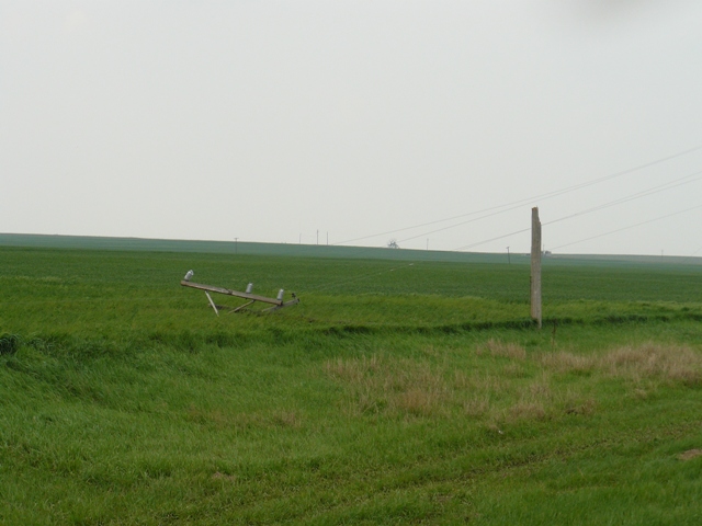
Power pole snapped by a tornado the night before near Claflin, KS.

p1000161

p1000161

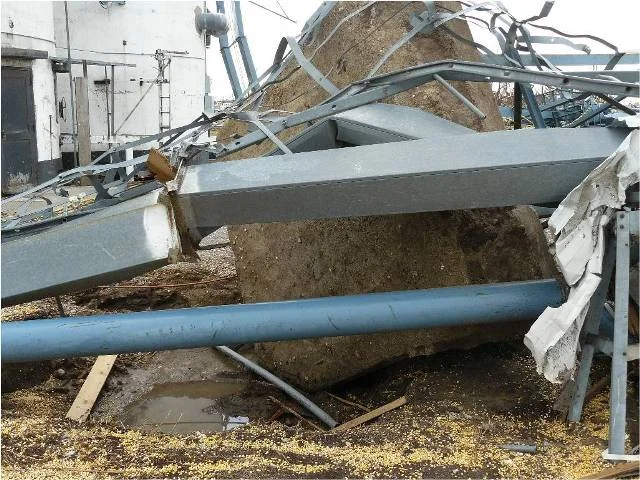
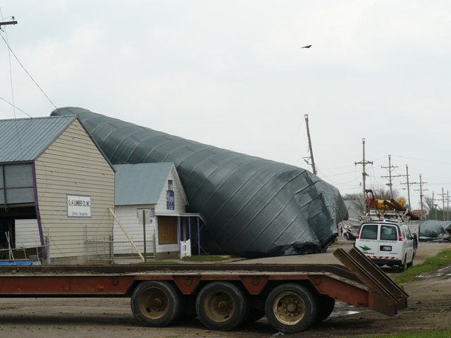
Grain bin thrown around 100 yards from a weak tornado that came through Claflin, KS the night before.

p1000171

p1000171

A tornado ripped the steeple off of this country church between Claflin and Ellinwood, KS the night before.

p1000180

p1000180

The tornado also took part of the roof and broke a few of the stain glass windows of the church.

p10001901

p10001901

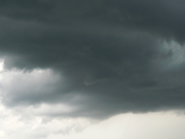
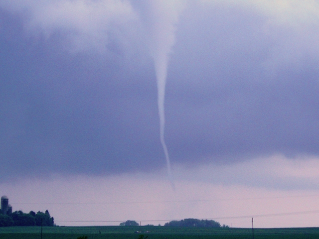
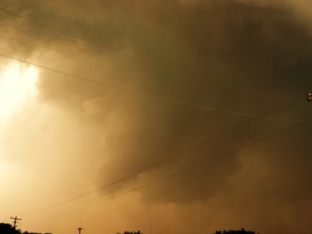
Funnel cloud that came within 3/4 of the way to the ground between St John and Pratt, KS.
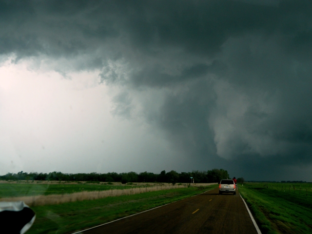
very-close-funnel

very-close-funnel

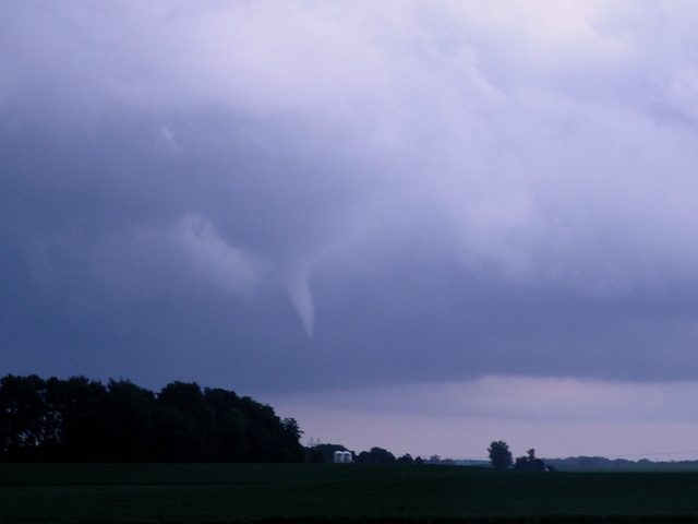
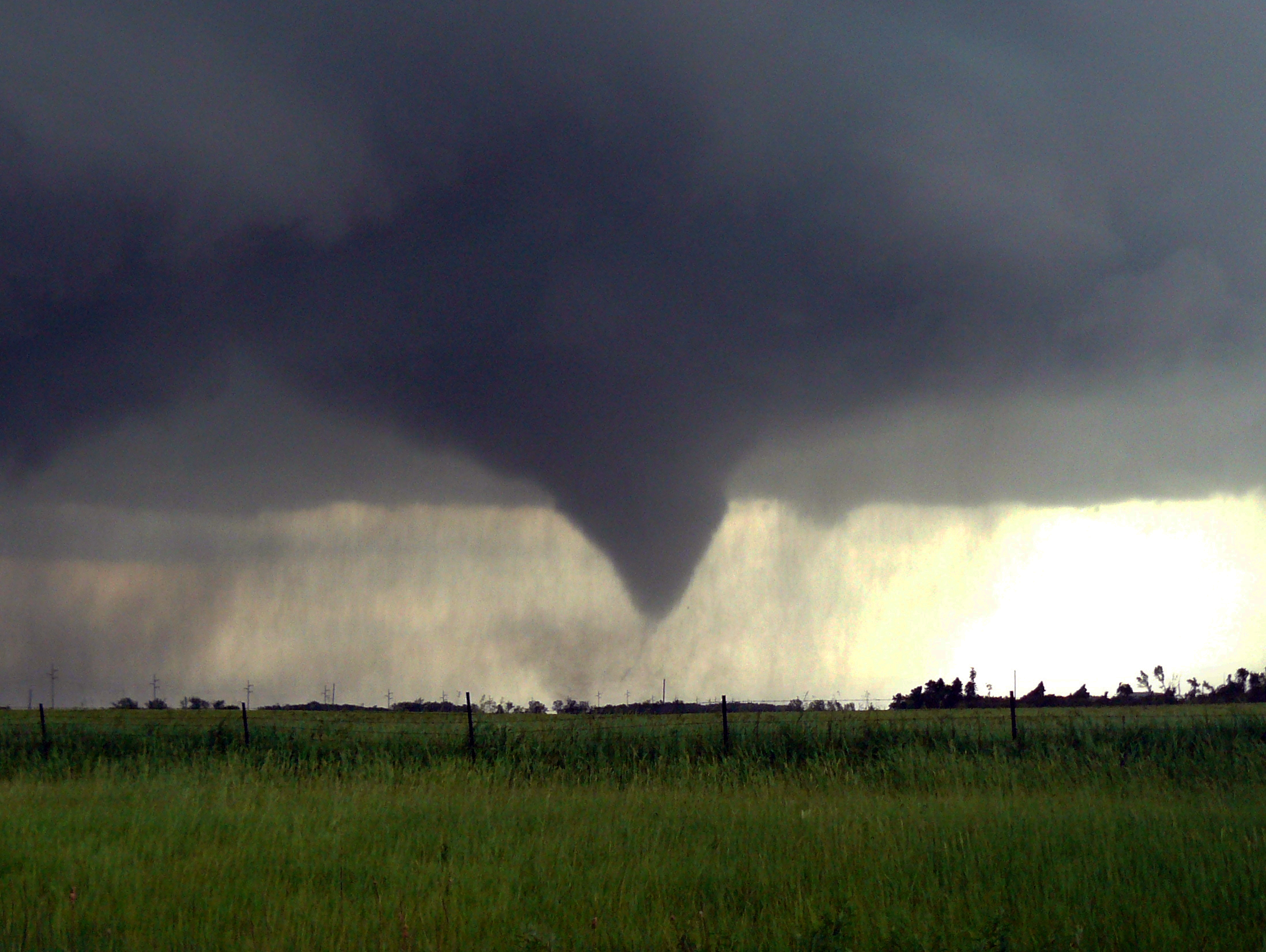
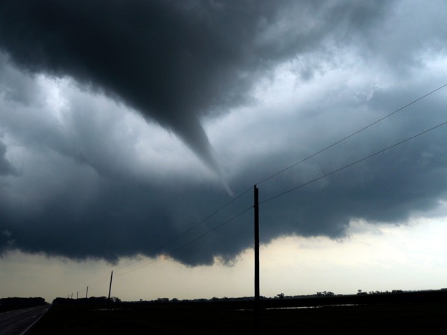
This is one of my favorite photos I have taken early in my chasing career.  This tornado did briefly touch down in the field about 40 yards in front of us.  It then crossed the road about 2 power poles away from our location.  This was near Stafford, KS.

halo-funnel1

halo-funnel1

 Image of the funnel as it crossed the road and began to occlude and rope out just to our north.

p1000282

p1000282

Image of funnel roping out and dissipating just to our north.
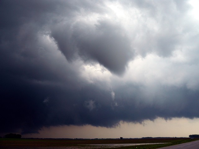
p1000293

p1000293

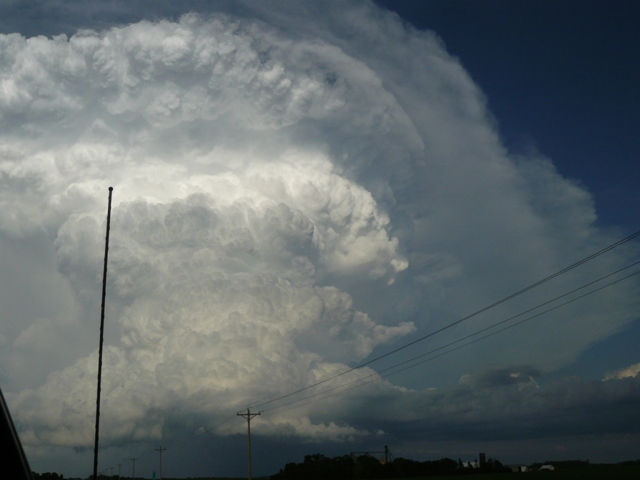
 View of a large funnel cloud directly ahead of us and the rear flank downdraft and subsequent hail core to our left.

 More photos from this day can be found here:  http://www.flickr.com/photos/39991047@N02/sets/72157621653451679/

Storm Reports:

070505_rpts

070505_rpts

May 4th Southwest Kansas Storm Chase - The Greensburg Tornado

05-04-07 CHASE LOG: KS

  First off, my thoughts and prayers will always be with the people of Greensburg on this horrific day of unspeakable destruction.  This storm chase involved our filming of the "Twister Sisters" reality show with Peggy Willenberg, Melanie Metz, Beau Gjerdingen, Eric Whitehill, MaryLynn Voth and the entire crew from Original Productions.  We started the day in Hays, KS right on the northern edge of a moderate risk day.  There was uncertainty into if the cap could be broken further south so we  hung around Hays till late afternoon and then meandered towards Great Bend, KS.  Intense supercells formed along the OK/TX border by late afternoon and we questioned going after these storms due to their distance and with more supercells firing on the triple point in southwestern NE, our secondary target.  We ended up moving south on Highway 281 towards Medicine Lodge, KS and then west on Highway 160 to Protection, KS just after the storm had split and we were on the right mover.  As we drove about 2 miles west of Protection, KS the inflow to the storm was absolutely amazing, gusting to near 40-50 mph INTO the storm.  It was the strongest inflow winds I have ever felt into a storm and for good reason.  I had pulled the camera's out of the back of the vehicle, only to realize that they had condensated over due to the dewpoints being in the lower 70's.  Therefore, I only was able to get limited pictures of the wall cloud and none of the tornado that began to form when we were on a dirt road just to the north of Protection, KS.  MaryLynn and I had become split of the group at this point and had were watching a tornado form several miles to our northwest while the eventual Greensburg Tornado started to touch down in a field 1/4 mile to our east around 9pm.  As we followed behind the tornado that was rapidly increasing in size, it was starting to become more difficult to see as nightfall was soon approaching.  The soon-to-be wedge tornado was only illuminated between the power flashes and the lightning and is an image that has been in my thoughts and nightmares since this night.  One of the more scary things was the weather radio saying over and over "A Tornado Emergency has been issued for Greensburg, KS.  A tornado is imminent and all residents must seek shelter."  MaryLynn, our camerman and I ended up in the town of Mullinville, KS looking at a traffic jam in the middle of a KS night on Highway 54 as the road had been shut down as a result of the first EF-5 tornado in history, sadly destroying the town of Greensburg, KS.  Below are some of the pictures from this day and some of the aftermath:

050407-1
050407-1

The beautiful shelf cloud out ahead of the left split of the Greensburg Supercell from our vantage point near Deerhead, KS.

050407-2
050407-2

The actual splitting of the Greensburg Supercell (on left) and the left splitting storm (on right) near Coldwater, KS.

050407-3
050407-3

Bad photo (I know) of the very tight and rapidly rotating wall cloud at the start of the Greensburg Tornado near Protection, KS.

picture11
picture11

All of the news outlets in Greensburg only 3 days after the tragedy.

picture2
picture2

A van that was thrown several times.

picture3
picture3

 A very large grain truck that was flipped.

picture4
picture4

 There was extensive tree damage throughout the town.

picture5
picture5

The U.S. flag being flown proudly after the town had been dessimated.

picture6
picture6

A pickup truck flipped from the winds of the tornado.

picture7
picture7

Another amazing picture of the destruction from this powerful tornado.

picture81
picture81

 A random piano thrown into the middle of a parking lot.

picture9
picture9

 A grain bin wrapped around a tree like tinfoil.

picture10
picture10

A slab of concrete completely ripped out of the ground.

picture12
picture12

Boards thrown as projectiles.

picture13
picture13

Incredible destruction the tornado caused in Greensburg, KS.  Debris spread for many miles.

picture14
picture14

One month after the tornado went through Greensburg, KS as the rubble has been cleared.

picture15
picture15

Another image of the entire town after having been cleared of the rubble one month later.

More photos from this day can be found here:  http://www.flickr.com/photos/39991047@N02/sets/72157621652591365/

And here:  http://www.flickr.com/photos/39991047@N02/sets/72157621654273947/

Storm Reports:

070504_rpts
070504_rpts

May 3rd North Central Kansas Storm Chase - Low Topped Thunderstorm Funnel

05-03-07 CHASE LOG:  KS

  This was not your typical "storm chase" as we were on a travel day to set up for the chase the following day.  This was the start of our filming of "Twister Sisters", a reality television show that MaryLynn and I were a part of in 2007.  The show aired in December of 2007 and January of 2008 with re-runs for a few years after.  The funny thing about this is that we were driving on I-70 between Salina and Russell, KS and came up over a hill and noticed a really nice cold air funnel that was halfway to the ground!  That was an amazing site to see as we were not expecting any severe weather this day, let alone any funnels.  The funnel formed from a low topped thunderstorm, then dissipated and recycled with a wall cloud before the storm weakened in strength.  Our crew of Suburbans and vans pulled off the Interstate to witness this "gift" that Mother Nature had given us.  It was a great start to one of the more fun experiences of my life...being a cast member in a television show.

050307-1
050307-1

This is the view of our dashboard in our suburban when we were filming for the Twister Sisters reality television show.  Notice the 3 dash cameras, one for the driver, another for the passenger, and another to look out the front window.  Quite the set-up.

050307-2
050307-2

View of the funnel a few miles to the south of the Interstate as we were traveling between Salina and Russell, Kansas.

050307-3
050307-3

Funnel cloud approaching Interstate 70 in north-central Kansas.

050307-4
050307-4

Wall cloud organizing a mile to the west of I-70 and several miles to the south of our position.

More photos from this  day can be found here:  http://www.flickr.com/photos/39991047@N02/sets/72157621770518272/

Storm Reports:

070503_rpts
070503_rpts

April 27th Northeast Kansas Storm Chase

04-27-07 CHASE LOG: KS   There is not much to show for this day as the Twister Sisters and I went down to northeast Kansas and spotted a few lowerings on a couple of supercells near Atchinson, KS.  These storms were moving to the northeast at close to 45 mph and were very difficult to keep up with.  Nothing ever came close to making even a nice wall cloud as the storms ended up quite linear rather quickly.

042704-1
042704-1

One of the not-so-impressive lowered bases near Atchinson, KS.

042709-2
042709-2

A neat shot of our view of one of the storms and one of the many unpaved Kansas roads.  We were sitting at a cemetary at this point which was a spooky place to view the storms as they passed.

More photos from this day can be found here:  http://www.flickr.com/photos/39991047@N02/sets/72157621645443005/

Storm Reports:

070427_rpts
070427_rpts

July 27th Southwest Wisconsin Storm Chase - Supercell and Wall Clouds


07-27-09 CHASE LOG:  WI

  Quite glad that I went out today as MaryLynn and I chased a couple of strong supercells through the rolling hills and trees that is southwest WI.It ended up being a surprisingly good day, all things considering.Upon leaving Burnsville, our course of action took us to Rochester, MN where we waited for initiation as a mesoscale discussion had been issued, talking about the development of supercells with primarily a damaging wind and large hail threat as well as an isolated tornado or two.A severe thunderstorm watch was then issued for all of southeast MN and most of south-central WI into northeast IA.Thunderstorms had already developed across the border right on the warm front into WI and, realizing the trough and associated wind shift were passing to our east, we decided to head east on I-90 towards La Crosse, WI.Storms in WI continued to get their act together and become severe, showing signs of strong rotation as we made it through La Crosse and towards Sparta, WI where we came upon the first storm of the day.This storm was still exhibiting strong signs of rotation and here is where we witnessed the first wall cloud, and a large wall cloud it was, although quite ragged.As the storm passed south of the Interstate near Sparta, we pursued on Hwy 71.This is where the VIL’s spiked and the storm started to have a couplet.We got directly out ahead of the wall cloud at this point as the motion started to greatly increase and inflow winds became stronger, also while we encountered some dime sized hail.I was rather nervous at this point being directly out ahead of the rapidly rotating wall cloud with the storm having a TVS signature on radar but, surprisingly, the storm never produced a funnel through the entire time we were watching, just outside the town of Norwalk, WI.  We continued south on County Road T ahead of the storm as different storm became tornado warned 35 miles to our southwest.This was the storm that dropped a confirmed tornado in southwest WI today.We were not able to get to this storm due to the bad road network and the likelihood that we would have to core punch the storm to have any chance of seeing anything.Therefore we stayed on our storm to the north and this storm ended up becoming tornado warned as we were witnessing another developing wall cloud, although short lived.Near Hillsboro, WI is when the chase ended as the storms congealed into a big HP mess.

rain-shaft
rain-shaft

Back edge of rain shaft on a storm in La Crosse, WI.We had to punch this storm to get out ahead to get to the storm near Sparta, WI.

wall-cloud
wall-cloud

Large wall cloud on the storm near Sparta, WI.  This storm was severe warned for large hail and damaging winds at this time.

22
22

Screen shot of the velocity imagery at the time we were approaching this storm near Sparta, WI.

action-area
action-area

Image of inflow into wall cloud from right to left.  Hail/rain core is on the left side of the image.

33
33

Velocity imagery near the time we had the strong rotation very close to us in the video.

wall-cloud-2
wall-cloud-2

Wall cloud near Hillsboro, WI shortly before the storm became tornado warned.

supercell1
supercell1

Anvil of supercell on I-90 near New Lisbon, WI as we got back on the interstate to head home.

sunset1
sunset1

Sunset near St Charles, MN on the drive home with towers going up close to the Twin Cities.

More photos from this day can be found here:  http://www.flickr.com/photos/39991047@N02/sets/72157621751427445/detail/

Storm Reports:

090727_rpts
090727_rpts

June 23rd Southern Minnesota Storm Chase - Shelf Cloud

06-23-09 CHASE LOG:  MN  

  I went with Donya Gjerdingen to southern Minnesota to get out ahead of an quickly approaching severe thunderstorms with a massive shelf cloud.  We left Northfield, Minnesota and drove down to east of Faribault, Minnesota on Highway 60 near the eastern shore of Cannon Lake.  Here, the storm approached us with a nice looking shelf cloud but was weakening and tending to fall apart as the gust front outran the main precipitation core.  We left this area and went further south to the Hope, Minnesota exit where the gust front and shelf cloud overtook us with winds only around 40 mph as the line continued to weaken.  Overall, not a great chase by any means but it was close and nice to see a decent shelf cloud, which I have not seen very many of so far this year.

Shelf Cloud
Shelf Cloud

Shelf cloud about to overtake Owatonna, Minnesota near Cabela's.  Notice the smoke from a fire rising up into the storm.

Dust
Dust

A lot of dust being blown around as the gust front approaches.  Dirt and dust was very thick and limiting the visibility as a result.

Whales Mouth
Whales Mouth

Underneath the shelf cloud after the feature overtook us.  Still windy as you can see the grass bent over in the ditch.

More photos from this day can be found here:  http://www.flickr.com/photos/39991047@N02/sets/72157621522145947/

Storm Reports:

090623_rpts
090623_rpts

June 21st Southern Minnesota/Northern Iowa Storm Chase - Alden Tornado


06-21-09 CHASE LOG:  MN

  Peggy Willenberg, Melanie Metz, MaryLynn and I decided to play the warm front this day and ended up heading down Hwy 169 from the Twin Cities to Algona, IA. On the way down, we did pass a developing storm with a VERY nice lowering near Elmore, IA. This storm was well north of the warm front and appeared to be moving quickly to the northeast into a not as favorable environment, so we continued south to Algona and sought after a storm that was looking impressive on radar as well as being right on the warm front. This storm did produce a couple of funnels east of Algona and then seemed to be undercut by the warm front and lag behind, therefore gradually weakening as the fast moving warm front continued into southern MN. Well, wouldn’t you know it, the storm that we passed up quickly became tornado warned near Blue Earth, MN. We waited around for several radar scans on the southern cell and then bailed towards the cell heading towards Easton, MN. The storm had reports of a few funnels and a tornado near Easton before we got there, but our crew managed to get on the storm between Easton and Wells where we witnessed a funnel ¾ of the way to the ground. It did not look like this touched down at that time. After lifting, we followed the storm past Wells, witnessed another funnel and then the tornado around 2 miles west-northwest of Alden, MN. It was interesting that the storm that produced the funnels and tornado near Easton and Wells was not the storm that produced the tornado near Alden. The storm that produced the tornado near Alden developed to the south and quickly became severe. The tornado formed on the eastern part of the storm, which was interesting because the inflow was out of the southeast of the storm and did not seem to be directly into the action area. The low level shear this day was very high while the deep layer shear appeared to be not as ideal. Therefore, the storms that went up were not supercells but were quite low topped with hardly any lightning and tops that had a difficult time exceeding 30K feet. Basically the tops could not reach far enough past the freezing level to produce any hail and even lightning. It was very interesting to see these low topped storms have so many lowerings, wall clouds, funnels, and overall motion.

Funnel1
Funnel1

First funnel cloud of the day near Algona, Iowa.

Funnel2
Funnel2

Second funnel cloud on a different storm further to the north near Easton, Minnesota.

Funnel3
Funnel3

Third funnel spotted on the same storm further to the east near Wells, Minnesota.

Funnel4
Funnel4

Fourth funnel cloud a short time later near Wells, Minnesota.

Funnel5
Funnel5

Fifth funnel cloud on a different storm moving up from the south between Wells and Alden, Minnesota.

Tornado
Tornado

Short lived tornado around 2 miles to the west of Alden, Minnesota.

Alden Tornado
Alden Tornado

A second picture of the tornado 2 miles to the west of Alden, Minnesota.

Rope Tornado
Rope Tornado

Tornado roping out near Alden, Minnesota.

More photos from this day can be found here:  http://www.flickr.com/photos/39991047@N02/sets/72157621646848788/

Storm Reports:

090621_rpts
090621_rpts

June 17th Southern Minnesota Storm Chase - Austin EF2 Tornado


06-17-09 CHASE LOG:  MN

  I chased with Twister Sister Peggy Willenberg today and we ended up targeting near the Mankato/New Ulm, Minnesota area for initiation.An intense supercell that later spawned the Austin, MN tornado quickly developed 25 miles southeast of Mankato and we were quickly on this storm near Geneva, MN.There was a large wall cloud on the storm that was being shielded somewhat from the intense hail core but we could see the edge upon following the storm to the east to Highway 218.Upon briefly getting cored with some nickel sized hail, we emerged very close to the meso, which was violently rotating on the northwest side of Austin and very low to ground.Under the meso, there was no condensation funnel at that time, but there was debris underneath the meso, so this was indeed the first touchdown of the tornado at that time.We then progressed south towards I-90 and came upon damage to structures, trees and downed power lines as well as snapped power poles.After getting through Austin and emerging on the southeast side of town, a newly developed mesocyclone let to a second touchdown, and much stronger, about 2 miles east-southeast of Austin.This tornado was much larger and had multiple vortices as shown by the video.This was quite the incredible but sobering experience at this point as the tornado sat over a farmstead and large wooded grove of trees for around 4-5 minutes about ¼ mile to our south-southeast.There was large structural damage done here as well as numerous power flashes with this tornado upon meandering slowly to the northeast.We also got into some golf ball sized hail at this point that did put a crack in the windshield.The tornado eventually diminished but soon cycled, with a third touchdown of the tornado as we traveled southeast on Highway 56 near Rose Creek, MN.  This tornado was a nice cone structure with a needle towards the ground and intense rotation about ½-1 mile away from us at that point.It did not appear that this third touchdown led to much in the way of damage, thankfully.Thereafter, we followed the storm further southeast towards Adams and Leroy, MN, witnessing a pair of horizontal funnels (very cool looking I might add) as well as an organized and rotating wall cloud that did not put down a tornado before we lost daylight, although it very much looked like it would at a few points in its cycle.All in all, a terrific chase day for us, close to home, and actually too close to home for me considering I grew up in this area and knew a lot of the areas that were hardest hit by these tornadoes.

P1030287-d.jpg

Image of the supercell taken near Amboy, Minnesota.

Updraft

Updraft

Strong thunderstorm updraft taken near New Richland, Minnesota.

Austin Tornado 1

Austin Tornado 1

Tornado 1/2 mile to the east of the Austin Municipal Airport.  This tornado went over a farmstead and caused considerable damage to that area.

Austin Tornado 2

Austin Tornado 2

Tornado 1/2 mile to the east of the Austin Municipal Airport.  Condensation finally reaching the ground here.

P1030316-BN.jpg

Tornado 1/2 mile east of the Austin Municipal Airport.  Police on the scene at the farmstead to the right of the tornado.

Austin Tornado 4

Austin Tornado 4

Tornado east of Austin, Minnesota.  Large wall cloud over the tornado as well.

Austin Tornado 5

Austin Tornado 5

Tornado 1 mile to the south of Rose Creek, Minnesota.  Final tornado of the day with this amazing storm.

More photos from this day can be found here: http://www.flickr.com/photos/39991047@N02/sets/72157621793443334/

National Weather Service Event Summary: https://www.weather.gov/arx/jun1709

Storm Reports:

090617_rpts

090617_rpts

May 8th Southern Oklahoma/Northern Texas Storm Chase


05-08-09 CHASE LOG:  OK/TX  

  Not a great day overall with rather weak shear and a cap till later in the day when storms were able to bust through.Models were consistently forecasting over near 5000 j/kg for the late afternoon and a non-capped atmosphere with precipitation breaking out in all the main model solutions. However, this was a cold front situation with weak southerly inflow winds resulting in not as favorable shear profiles as one would hope. Also, another limiting factor was the weak upper level support and really little to no jet support. All in all, not a great day but it was nice to see some severe storms and a few wall clouds.

  We started the day in Davis, OK and sat around in a church parking lot till 5pm when things really started to get going. We first went to check out the initially developing storms to the north of Ada. These storms had skinny updrafts and were not all that impressive, but had some decent updraft bases nonetheless. Not liking the overall look of these storms, we doubled back down to near Davis where some more impressive cells were going up to the west of I-35.These storms quickly had shear and hail markers and quickly became supercellular with severe thunderstorm warnings issued by the NWS. We did take a few wall cloud pictures and some storm structure. A better storm soon developed to the east of Wichita Falls, TX, just to the south of the Red River. We bailed on the northern storms and shot down I-35 to Gainesville, TX and then west on Hwy 82 to near St Jo, TX. As we approached this storm, it was after sundown and starting to get really dark, but it did become tornado warned with radar certainly indicating some strong rotation and an impressive hook. I tried to shoot some lightning pics here but there was just not enough to get some decent pictures and we could not see under the base at that point to see if there was any sort of lowering. After that, my wife and I drove through the night to get back to Burnsville before noon the next day. We made it in 11 hours, but I wouldn’t recommend doing it after chasing that day. What an incredibly long drive! But with 2 drivers, it was doable.

Minnesota Road
Minnesota Road

In Oklahoma, we noticed a sign for Minnesota Road!

Wall Cloud
Wall Cloud

Non-rotating wall cloud on our first storm of the day near Ada, Oklahoma.

Wall Cloud 2
Wall Cloud 2

Image of a wall cloud and inflow on a supercell near Davis, Oklahoma.

Sunset Thunderstorms

Thunderstorms developing in the distance at sunset.

More photos from this day can be found here:  http://www.flickr.com/photos/39991047@N02/sets/72157621669956731/

Storm Reports:

090508_rpts
090508_rpts

May 5th North-Central Texas Storm Chase - Supercell and Funnel


05-05-09 CHASE LOG: TX  

  Not too bad for the first chase of the year!  My wife and I started out the day in a cockroach infested motel room in Wichita Falls…actually by far the worst motel room I’ve ever slept in.Ended up meeting Theresa and Chris in Haskell where we sat around till 3:30pm and went south towards Abilene.  Had a nice CU field upon reaching Anson but noticed the CU was being eroded quickly from the west so we decided to follow the more robust CU on Hwy 180 east towards Albany.  MaryLynn and I ended up sitting around Albany for a little while before heading southeast to I-20 as a new MD was issued with development being imminent.  The thinking here was that storms would develop along Hwy 180 from Albany to Breckenridge and then slide southeast towards the Interstate where we would be in perfect position.  Well, the storm near Breckenridge was clearly elevated at first and quickly moving to the northeast.  We considered going north to intercept this storm, but decided against it due to the elevated nature and how quick it was moving, not to mention not being all the impressive on radar.

  The storm of the day developed near Breckenridge in the wake of the first storm and we came up on this cell from the southeast on some unmarked road and Ranch Road 717 as it was starting to mature and become surface based fairly quickly.  The first shot below is what I believe to be a large funnel that did form near Necessity to the southeast of Breckenridge.  In the picture you can see the RFD cutting in from the left.This funnel had to have only lasted around a minute, if that, but it did get rather far down.  Thereafter, we drove underneath the meso on I-20 to try and get ahead of the storm with a south road option and encountered some rather interesting wind shifts and incredibly fast moving rain curtains as we did so.  I have some video of this and, if it looks alright, I may post it later.  Saw the TIV on our south road option of Hwy 16 and then got some lightning shots as it turned dark just west of Stephenville as the storm really started to die.

  I did take quite a bit of video today, as well as a poorly constructed time lapse.  Also, I know the Vortex 2 was not out yet but, wow, there were a ton of chasers down here!It’s wasn’t terribly bad, though, as everyone seemed to mind the road alright and not do anything stupid.  Quite the caravan trying to get ahead of the storm and to I-20 in time before we got cored.  Needless to say, we made it but, had we been there a few minutes later, we definitely would have gotten cored by the 4 inch hail that some storm chaser reported totaled his car.

Breckenridge Storm
Breckenridge Storm

This is the supercell quickly developing near Breckenridge, TX.  This storm quickly went supercellular and was tornado warned after 45 minutes of initiation.

Breckenridge Funne
Breckenridge Funne

Here is a funnel cloud to the southeast of Breckenridge, TX.

Breckenridge Funnel 2

Another picture of the large funnel cloud to the southeast of Breckenridge, TX.  Notice the RFD cutting in from the left of the funnel.  The funnel was short lived and only lasted around a minute and did not touch down.

5-5-09-lightning
5-5-09-lightning

Lightning shot when storm was in dissipating stage near Stephenville, TX.

5-5-09-lightning-2
5-5-09-lightning-2

Another lightning shot near Stephenville, TX at the end of the chase day.

More photos from this day can be found here:  http://www.flickr.com/photos/39991047@N02/sets/72157621794019518/

Storm Reports:

090505_rpts
090505_rpts