June 7th Eastern Iowa and Northwest Illinois Storm Chase - Fast Moving Supercells and Wall Clouds
06-07-07 STORM CHASE: IA/IL
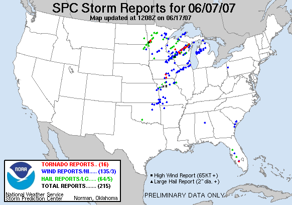
After chasing the day before in the Badlands of South Dakota, our group consisting of myself, the Twister Sisters, Karen Miller, Beau Gjerdingen, Eric Whitehill and the crew from Original Productions found ourselves leaving Fremont, NE. We planned on targeting east-central IA where there was a High Risk issued by the Storm Prediction Center for severe weather and tornadoes. This was our last day of chasing for the television show and we wanted to make it a good one, although storms were expected to be moving very fast off to the north-northeast. Storms began to fire before we could even reach our target area and our group quickly made it east of Des Moines on I-80, planning on intercepting a line of training thunderstorms that were becoming supercellular south of the interstate and quickly moving north. Upon reaching Gonoa Bluff, IA, we moved south on Highway V52 to intercept a good looking cell near North English, IA. We watched a pair of developing supercells cross ahead of us by a few miles, both having lowerings/bases as they went by, but nothing all that interesting. We decided to follow these cells northeast and soon realized we would have a tough time keeping up as the storms were moving at 40-50 mph. Many chasers may think that this was a wasted cause, but we persevered as every storm that went up was becoming tornado warned or exhibiting signs of rotation. The cells crossed I-80 near Iowa City, IA, and we were actually able to get out ahead of the storms and progress north on Highway 1. The best wall cloud that we saw this day was viewed near Mt Vernon, IA (as seen below) when the storm was tornado warned, but the storm never produced any funnels as far as we could tell. Our car ended up being the only car in the group to attempt to stay ahead of the storms any further as they were moving so fast. To do so, we had to quickly move east on Highway 30 to the east of Mt Vernon and then north on Highway Y24 in Lowden, IA. At this point, the storm was tornado warned again as we intercepted near Lost Nation, IA and this is where another nice wall cloud formed with a lot of rotation. Unfortunately, this is the best the storm ever looked but we still followed east on Highways 136 and 64 where we crossed the MS River at Sabula, IA. We ended up following the storm till nightfall and reached Forreston, IL before finally giving up the chase and heading back to Iowa City, IA to meet back up with our crew. All in all, several nice wall clouds and lowerings on this day.

First storm of the day with a lowered non-rotating base near North English, IA.
Nice wall cloud with feeder band near Williamsburg, IA.

Lowered base and condensating inflow air into the storm near Iowa City, IA.

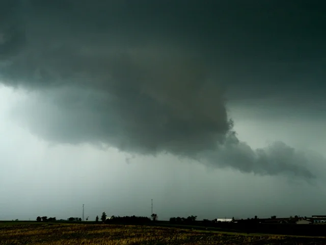
Rotating wall cloud in Mt Vernon, IA.

Lowered base of a supercell near Lost Nation, IA.

Action area of the storm with inflow and lowerings on the MS River near Savannah, IL.
More photos from this day can be found here: http://www.flickr.com/photos/39991047@N02/sets/72157621799857036/