May 23rd Northwest Kansas and Texas Panhandle Storm Chase - Supercell With Wall Cloud Hugging the Ground, Funnel and High Precipitation Supercell
05-23-07 CHASE LOG: OK/TX
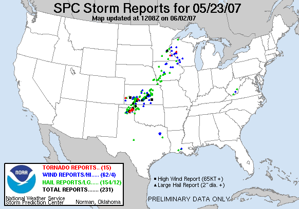
It was a long drive to start the day as we started out in Hays, KS and ended up in the TX Panhandle by the end of the chase day. Our groups consisted of MaryLynn and myself, Peggy Willenberg and Melanie Metz, Bill and Cullen Doms, as well as our camera crews that were shooting for "Twister Sisters". Driving down Highway 183, we stopped once again in Greensburg, KS and witnessed a caravan of trucks hauling away the wreckage of the town and a massive effort to clear the town of the destruction and start the rebuilding process. The tons of wreckage was being hauled out to a large dug out pit about a mile outside of town where it was being burned. This was quite the site to see at this point as we had witnessed the destruction of the town first-hand on May 4th. After stopping for a glimpse, we progressed south across the KS/OK state line as a PDS Tornado Watch was issued for the TX Panhandle and western OK. Storms erupted near the 4pm hour across this area, the first that we witnessed near Fort Supply, OK. This storm quickly went tornado warned and produced a massive wall cloud that hugged the ground on the other side of a ridge. The wall cloud stuck around for quite a while before lifting, cycling and producing a brief funnel upon approaching our location. We did think that we were witnessing a wedge tornado but could not tell for sure since the ridge in the distance was blocking our view if the wall cloud had actually been on the ground or not. Bill later confirmed that he did not witness a touchdown as he was in closer proximity to the storm. After the storm began to weaken, but decided to drop south towards a stronger and still developing storm that many chasers were converging on in the area. This storm had all the characteristics of a high precipitation supercell as we intercepted about 5 miles west of Lipscomb, TX. It was very difficult to see any features due to the massive rain and hail core, but the storm had separate areas that were going outflow dominant and producing shelf cloud features, while others were wrapped up with a lot of rotation and mesocyclones. At the leading edge, we were able to get a very good view of this storm as it approached, along with a lot of chaser convergence, the TIV, DOWS team and even a helicopter doing live reports on the storm. Nearing nightfall we met up with the Twister Sisters and their crew while the storm produced a funnel and apparently touched down 3 miles to our northwest as a storm report had confirmed. We did not witness the touchdown but did see a large funnel embedded in the rain at that time. When visibility was greatly restricted, we ended up driving through another strong storm with hail near Woodward, OK and on to Enid, OK to spend the night.

Large wall cloud close to the ground underneath a supercell near Fort Supply, OK.

Large wall cloud and funnel close to the ground on the other side of a ridge near Fort Supply, OK

Wall cloud hugging the ground with a sharp edge on the right with strong vertical motion near Fort Supply, OK.

Wall cloud with rapid rotation and vertical motion as noted by condensation rising on the right side, near Forth Supply, OK.

Zoomed out view clearly showing the strong updraft of the storm with wall cloud underneath near Fort Supply, OK.

Funnel from the storm upon approaching our location near Fort Supply, OK. The radar was indicating strong rotation and a TVS signature at this time.

Running into the TIV in the Texas Panhandle.

Massive high precipitation supercell near Lipscomb, TX. Notice the mesocyclone as the outflow wraps into the storm on the leading edge.

Yes, a blurry photo, but this is all I have of a funnel embedded in the rain core towards nightfall on the storm near Lipscomb, TX. A tornado touchdown was reported around this time.
More photos from this day can be found here: http://www.flickr.com/photos/39991047@N02/sets/72157621791300400/