
MARCH 5, 2022 IOWA: MY EARLIEST TORNADO OF ANY SEASON AND MY SON'S FIRST!

First severe storm of the day just west of Shenandoah, Iowa. We got on this one right away.

Tornado warned storm south of Red Oak, Iowa. This is looking to the southwest as the base was coming right at us.

Beautiful flanking towers going up on the southern end of what would become the tornado producing supercell that traveled over 100 miles to Des Moines and points east-northeast of there.

The contrast here around the rainbow was fantastic. Like a clear boundary of light and dark.

This was before our tornado and could have produced here well ahead of us as we were traveling east on Highway 34 near Corning.

Short lived funnel cloud right there in the middle shortly before producing the tornado near Prescott, Iowa.

Tornado! Near Prescott, IA at 4:06 pm. Unfortunately tearing up a barn and other farm structures.

Another shot of the tornado. Notice the condensation funnel overhead.

Funnel cloud, possible tornado, north of Macksburg, Iowa. Might be the start of the killer tornado that impacted Winterset.

Another shot of the persistent funnel cloud, possible tornado.

Ping pong ball size hail as we approach the town of Orient, Iowa.

BIG hail covering the ground everywhere in Orient, Iowa. Lots of windows busted out and tree damage.

You can see the car window busted out here due to the massive hail.
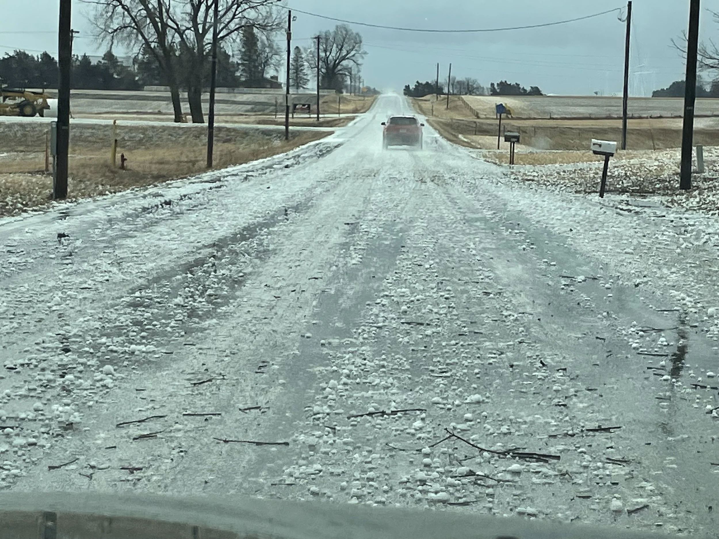
The car was sliding all over the road here due to all of the hail.


Tornado damage in Winterset, Iowa. There was so much more that was way worse than this even. Very sad.

Tornado damage to a hour to the northeast of Winterset, Iowa.

Trying to get ahead of the storm! Was really hard to keep up with since it was moving 50+ mph and we kept running into debris and small towns. Nice updraft and inflow tail here.

Coming across more tornado damage in Norwalk, Iowa. Hwy 28 impassable due to debris so we were forced to turn around and find another route.

Major damage to a shed in Norwalk.

More damage to homes and a church in Norwalk.

Tornado debris across the road in Pleasant Hill, Iowa on the eastern side of Des Moines. This was off highway 65 in the eastern metro.

Mammatus from the storm to the south as we were about to get around the east side of Des Moines and into I-80.

Spooky scene as we were blasting east to still try and get ahead of the tornado warned storm approaching Newton, Iowa. Storm still had a tornado at this point. Soon after had to call off the chase as I-80 slowed down to a crawl due to an accident.
MESOSCALE DISCUSSIONS AND WATCHES:

   SUMMARY...Storms are expected to gradually increase in coverage and
   intensity this afternoon. A few tornadoes, damaging winds, and large
   hail all appear possible. Watch issuance is likely in the next
   couple of hours.

   DISCUSSION...An area of precipitation with embedded storms is
   ongoing early this afternoon across parts of western/central IA and
   vicinity. This activity is being aided by strong low-level warm and
   moist advection occurring with a 40-50+ kt south-southwesterly
   low-level jet. As pronounced ascent associated with a shortwave
   trough ejecting across the central Plains overspreads the warm
   sector across IA and northern MO, additional convection is forecast
   to develop over the next couple of hours. The airmass across this
   region is gradually destabilizing, with surface temperatures
   generally in the mid 50s to upper 60s, and dewpoints in the low to
   mid 50s. Around 500-1000 J/kg of MLCAPE may ultimately develop as
   modest diurnal heating through cloud breaks occurs, as mid-level
   temperatures are expected to rapidly cool with the approach of the
   shortwave trough. Deep-layer shear of 50+ kt will favor supercells
   with a threat for both large hail and damaging winds.

   There is still some uncertainty in the coverage and intensity of
   severe storms later this afternoon owing to the modest instability
   and leading band of ongoing storms, which may hamper additional
   diurnal heating. Potential does exist for this leading band to
   strengthen as it moves across central/eastern IA while posing a
   threat for mainly hail and strong/gusty winds. Current expectations
   are for a greater severe threat to develop with supercells that
   should form near the NE/IA/MO border, in close proximity to the
   surface low over northeastern KS. This activity should have access
   to slightly greater instability and low-level moisture, with a
   better chance for these storms to become surface based and produce
   isolated large hail. Strong low-level wind fields and 200-300 m2/s2
   of effective SRH should prove favorable for updraft rotation, and a
   few tornadoes appear possible with any storms that can remain at
   least semi-discrete. Scattered damaging winds should also occur as
   convection attempts to grow upscale later this afternoon/early
   evening while moving quickly eastward across IA and northern MO. A
   watch will likely be needed within the next couple of hours as the
   severe threat gradually increases.
   SUMMARY...Thunderstorms are expected to develop this afternoon along
   a cold front moving into western Iowa/Missouri.  These storms will
   track across the watch area, posing a risk of damaging winds, hail,
   and a few tornadoes.

   The tornado watch area is approximately along and 85 statute miles
   east and west of a line from 60 miles north northwest of Des Moines
   IA to 40 miles south of Lamoni IA. For a complete depiction of the
   watch see the associated watch outline update (WOUS64 KWNS WOU7).
   SUMMARY...Ongoing severe storms should continue to track east
   northeast over the next several hours across IA and northern MO.
   Damaging wind gusts, large hail and a few tornadoes will be
   possible. Some upscale growth is expected as storms track farther
   east into central and eastern Iowa later this evening.

   DISCUSSION...As of 21:45 UTC, a semi-discrete band of supercells
   were ongoing across far southwestern IA and northwestern MO. In the
   wake of early-day storms, clearing ahead of a strong surface cyclone
   and upper trough have allowed weak destabilization (500-1000 J/kg)
   of MLCAPE to propagate ahead of the cells ongoing across central IA
   and northern MO. These storms should continue to keep pace with the
   rapidly recovering warm sector posing a risk for all hazards over
   the next few hours.

   Initial storm mode has been messy with multiple updrafts in close
   proximity across western IA. This is likely a result of
   relatively-long straight-line hodographs above weekly veered surface
   flow. Additional upscale growth appears likely with these storms as
   they track northeastward. All hazards, including damaging wind
   gusts, and a few tornadoes will however remain possible given strong
   low-level shear (0-1km srh 150-200 m2/s2) supporting small
   mesocyclones.

   Farther south, more discrete convection across northern MO were
   tracking toward southern IA. Greater residence time within the
   expanding warm sector and resulting stronger low-level mesocyclones
   may result in a locally greater risk of tornadoes over the next
   several hours. Upscale growth into more linear segments with a risk
   of damaging gusts appears possible into portions of eastern Iowa
   where an additional watch may be needed later this
   afternoon/evening.
   SUMMARY...The tornado threat will be focused in parts of central and
   southeast Iowa this evening. This threat may extend beyond the WW 27
   and an additional downstream tornado watch will likely be considered
   this evening.

   DISCUSSION...A strong supercell continues to move through southern
   suburbs of Des Moines. This storm has had consistent rotational
   velocities in the 55-70 kt range over the past hour. Other discrete
   storms are moving out of north-central Missouri into south-central
   Iowa. At least one tornado was reported in Wayne County, IA, with
   this activity. These storms are moving into a similar environment
   and will continue to pose a threat for tornadoes over the next 1-2
   hours. To the west of these discrete storms, a more broken line of
   convection has developed along the cold front. This activity will
   pose greater threats for large hail and damaging winds than
   tornadoes.

   Farther to the north and east, earlier cloud cover and precipitation
   has limited destabilization. For parts of eastern Iowa and perhaps
   far northeastern Missouri, an additional downstream tornado watch
   will need to be considered this evening.
   SUMMARY...Storm mode has trended more linear in WW 29. Low-level
   wind fields will still support damaging wind gusts and brief
   tornadoes.

   DISCUSSION...Modest destabilization continues ahead of a broken line
   of quasi-linear storms in eastern Iowa and far northeastern
   Missouri. Though storm mode has trended less discrete, regional
   radar velocity data has shown periodic embedded circulations
   developing within the line segments. A couple of measured severe
   gusts were reported within the last hour in eastern Iowa. Given the
   strong low-level shear and veering seen on the KDVN VWP, there will
   be continued potential for this sort of activity. Damaging winds and
   brief tornadoes will be the primary threats. The observed DVN 00Z
   sounding showed an 8 C/km mid-level lapse rate which would also
   support marginally severe hail, despite the less favorable storm
   mode.
