
APRIL 12, 2022 IOWA: CLOSE RANGE EF2 TORNADO CHASE NEAR GILMORE CITY
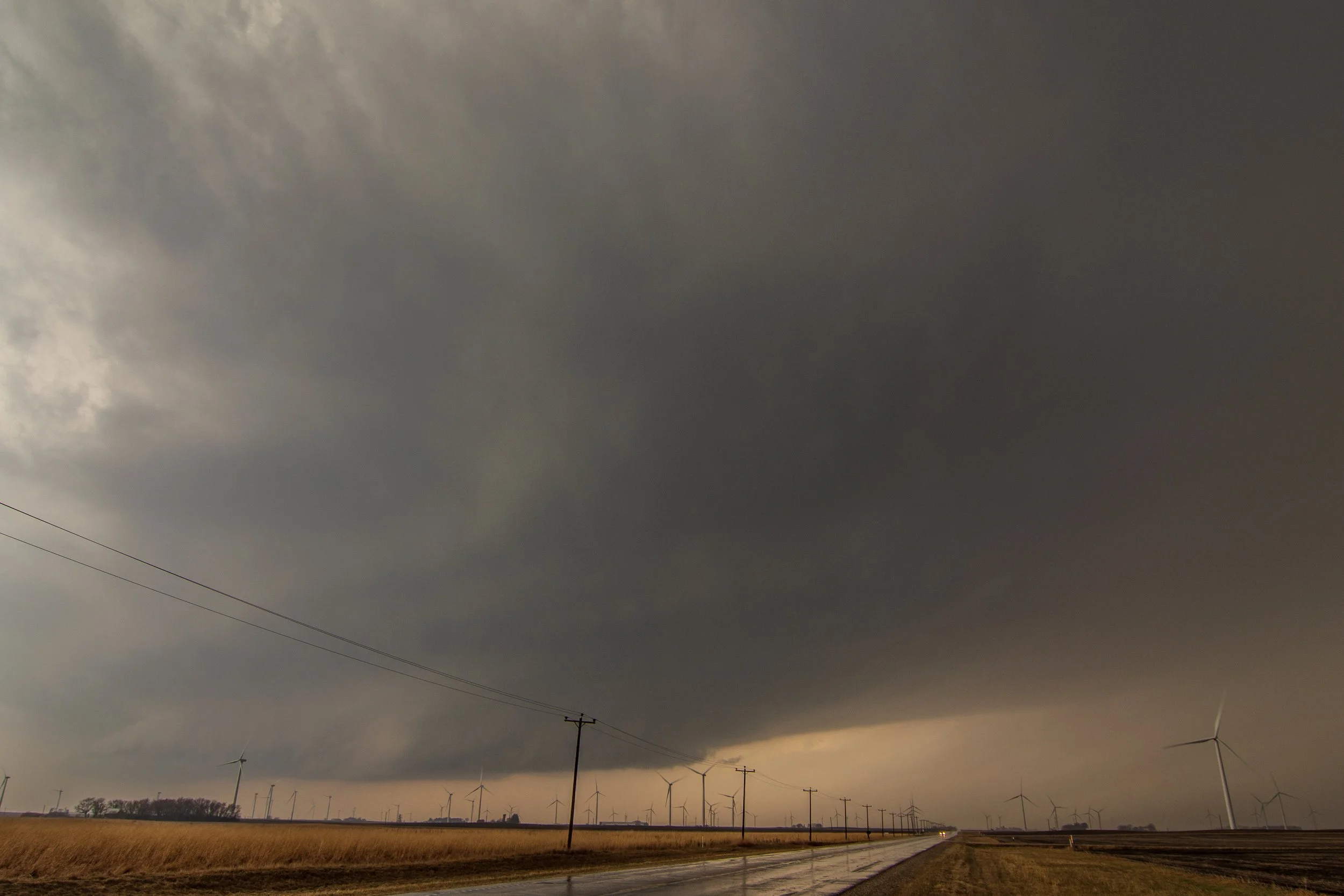
Severe warned storm to the south of Fonda, Iowa. Already getting that look to it with a broad, rotating wall cloud at this point.

Storm still looking good and intensifying as it approaches us.

Here it comes! Had to bail shortly after this photo was taken due to the proximity of the wall cloud moving overhead and hail starting to fall.

Mothership structure to this storm as it became tornado warned and soon dropped a tornado. Big blocky lowering in there on the left that was rotating hard.

TORNADO!! No condensation funnel making contact yet but the tornado is definitely down as it began churning up dirt over the field ahead of us. This is looking to the northwest near Palmer, Iowa.

Tornado starting to fully condensate to the ground. Nice and clear mesocyclone rotating above the tornado.

Tornado taking on the shape of a thick elephant trunk at this point.

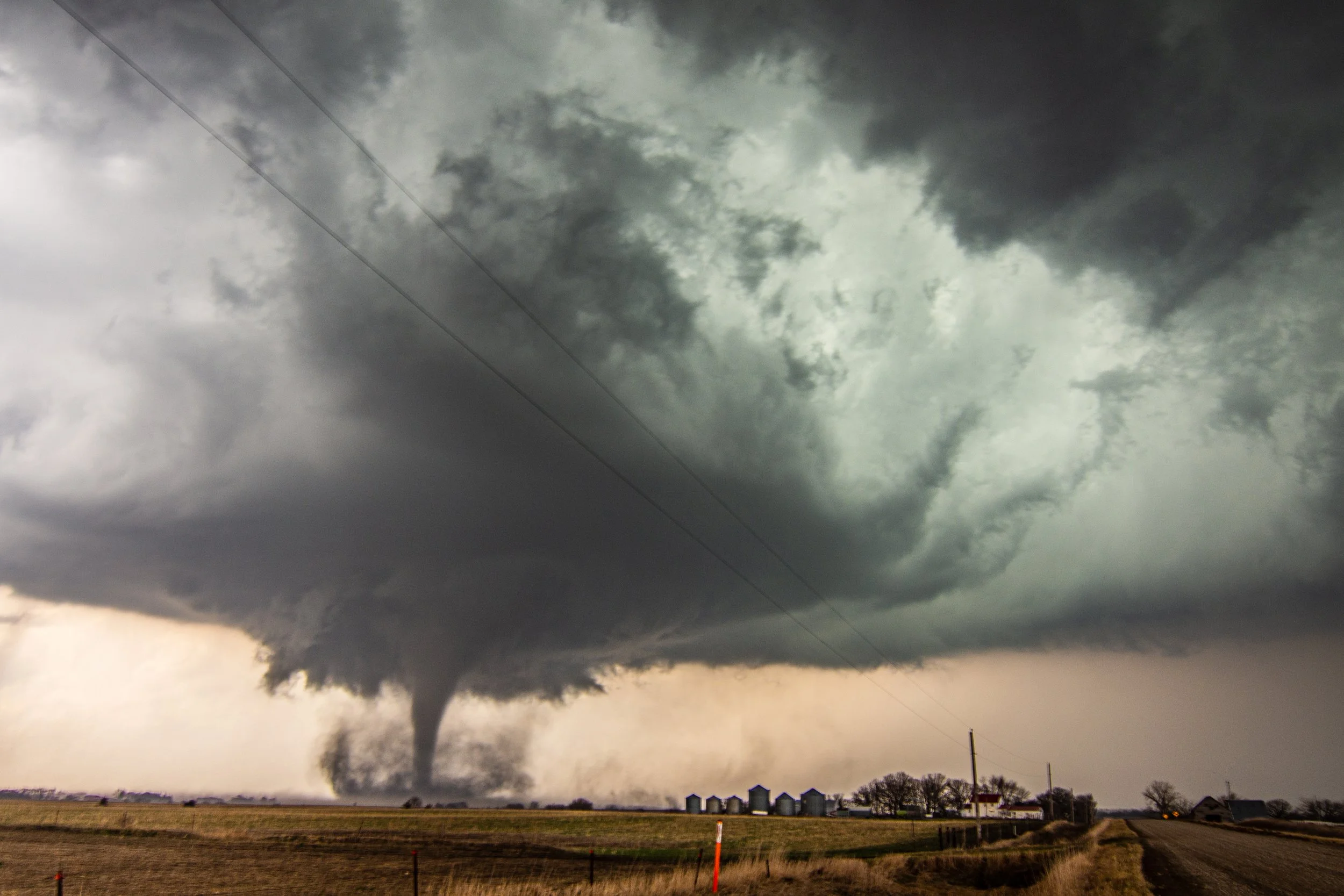

After the initial touchdown in the previous photos, we drove up at it and got closer as the tornado planted once again and became stronger. Now between Palmer and Gilmore City. The tornado ended up being rated an EF-2 with a path length of 7.4 miles and peak winds of 115-125 mph!
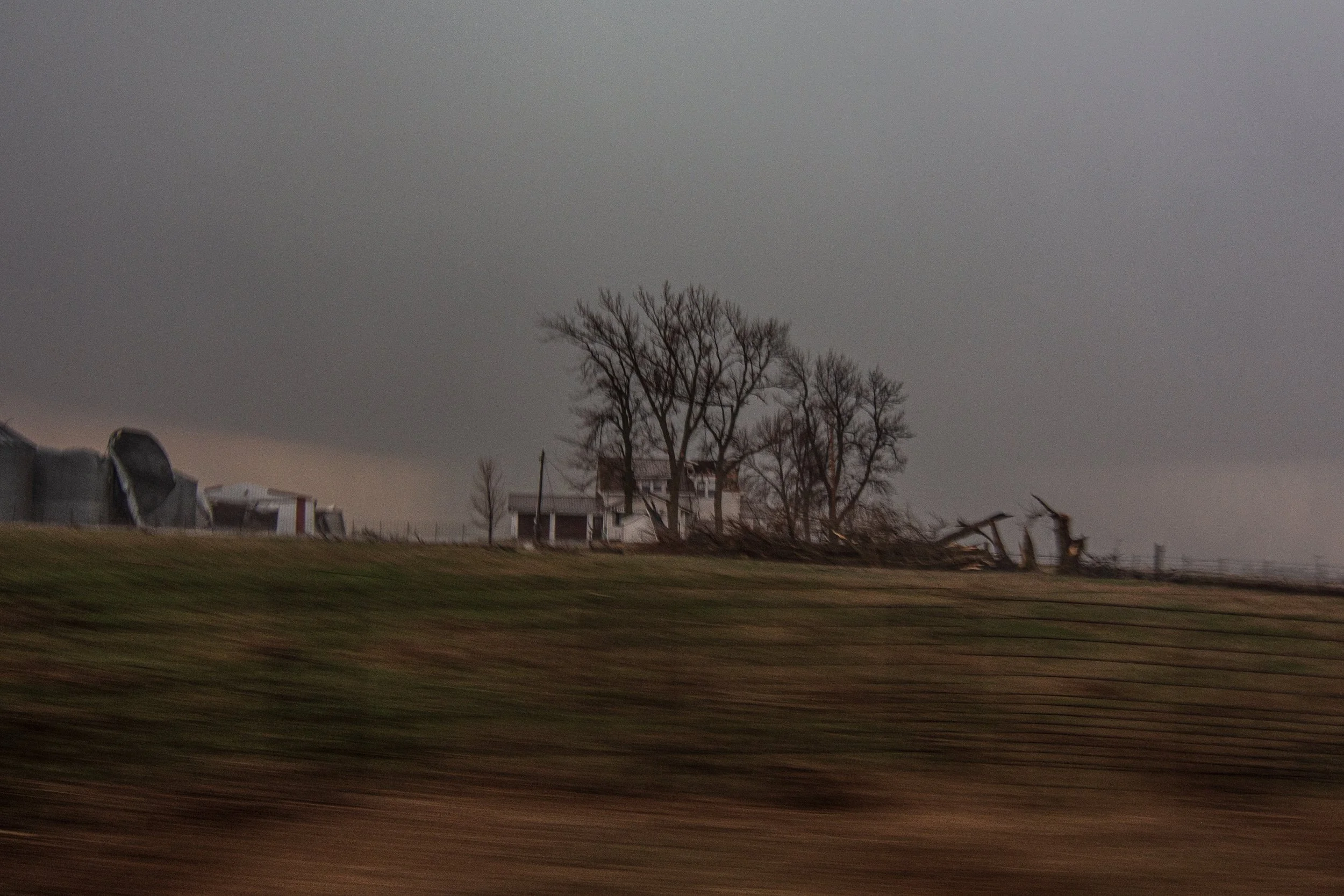
Damage to a farmstead. Lots of tree and grain bin damage but appeared to be fairly minor damage to the house.

Grain bin destroyed with corn spilling out. Sheet metal from the grain bin was strewn downwind throughout the field for miles.

Tornado occluding and starting to weaken near Gilmore City, Iowa. This storm went on later to product another tornado that we could not get a view of.

Got back ahead of the tornado warned storm Kanawha, Iowa. Very dark at this point but could make out what appeared to be a base embedded in there.

The path of the tornado in yellow and the path we took with our vehicle in red, coming up at it from the south.
National Weather Service Summary
WATCHES AND MESOSCALE DISCUSSIONS:

   SUMMARY...Convective initiation is expected by around 21-23z. A
   tornado watch will likely be needed in the next hour or so. Severe
   thunderstorms capable of large hail, damaging gusts and a few
   tornadoes are possible.

   DISCUSSION...A surface low is located near the central NE/SD border
   as of 19z. A warm front was noted in surface analysis arcing from
   the low across northeast NE into southern IA. Meanwhile, the surface
   cold front was located across central NE and rapidly approaching the
   surface dryline just a few counties to the east. Increasing cumulus
   has been noted in visible satellite imagery along the dryline and
   across the warm sector to the east across northeast NE. The cumulus
   along the dryline has shown modest vertical development where
   capping is likely less than further east. As the warm front
   continues to lift northward and better quality boundary-layer
   moisture works northward in conjunction with strong large-scale
   ascent, convection is expected to develop near the triple point by
   21-23z.

   Initial convection across southeast SD into southwest MN to near the
   NE/IA border may be elevated near/just to the cold side of the warm
   front, with a better-quality warm sector remaining quite narrow from
   near the MO River into northwest IA. Fast storm motion toward the
   northeast could result in these storms rapidly moving away from the
   better warm sector as they mature. Nevertheless, strong vertical
   shear, steepening midlevel lapse rates and sufficient instability
   should support organized supercells capable of large hail and
   perhaps strong gusts. Any storm that develops in the better warm
   sector or that can anchor to the warm front will access better
   low-level shear and see an increased risk for tornado development.
   Furthermore, any storm that develops further south along the cold
   front/dryline in NE may be higher-based, posing a threat for large
   hail and damaging gusts. If any dryline convection persists eastward
   into better moisture, these cells also could become surface-based
   within the better-quality warm sector with a corresponding increase
   in tornado potential. With time into the evening, more linear
   convective development is expected near/east of the MO River as the
   cold front surges east.
   SUMMARY...Supercell development will be possible in the next couple
   of hours, near and east of a surface cyclone along the
   Nebraska/South Dakota border.  The storm environment will continue
   to become more favorable for a few tornadoes (a couple of which
   could be strong) and very large hail, if storms can mature quickly
   enough in the relatively narrow, unstable warm sector near the warm
   front.  Damaging winds will also be possible, especially late this
   evening when storms could grow upscale into a squall line along the
   cold front approaching from the west.

   The tornado watch area is approximately along and 60 statute miles
   east and west of a line from 50 miles northeast of Yankton SD to 45
   miles south of Sioux City IA. For a complete depiction of the watch
   see the associated watch outline update (WOUS64 KWNS WOU1).

   SUMMARY...Sustained strong supercells appear increasingly likely
   through early evening.  Some probably will pose a risk for producing
   tornadoes, particularly around the Storm Lake and Fort Dodge IA
   areas by 7-9 PM CDT, where a strong tornado or two is possible.
   Additional, a severe thunderstorm watch will probably be issued soon
   to the north of the current watch, where severe hail may become an
   increasing concern this evening.

   DISCUSSION...Thunderstorms are now initiating along the warm frontal
   zone, north through east of a deep surface cyclone slowly migrating
   east-northeast of the Sioux City area.  This is being supported by
   lift driven by low-level warm advection, and perhaps a subtle
   mid-level perturbation forecast to migrate north-northeastward
   across the mid Missouri Valley around Sioux City through early
   evening.

   The strongest thunderstorms probably will tend to evolve along the
   front to the east-southeast of the warm front/dryline intersection,
   now generally east of the Missouri River, where a narrow tongue of
   modest boundary-layer moistening wrapping toward the surface low
   center may be contributing to mixed-layer CAPE as high as 3000 J/kg
   to the southwest of Fort Dodge.  Into the the 00-02Z time frame,
   southerly 850 mb flow across the narrow warm sector, into and across
   the warm frontal zone is forecast to strengthen to 50-60+ kt,
   contributing to very large, clockwise curved low-level hodographs.

   As this occurs, the warm frontal zone is expected to become the
   focus for intensifying supercells, including the evolution of strong
   low-level mesocyclones, potentially capable of producing tornadoes.
   The warm front is rather sharp, and the air to the north of the
   front rather cool and stable.  However, the front is slowly
   advancing northward, and model forecast soundings indicate low-level
   thermodynamic profiles will destabilize across much of northwestern
   through north central Iowa into early evening.  It appears possible
   that this will become sufficient for tornado development, with
   highest probabilities for sustained/longer track tornadic supercell
   development around the Storm Lake/Fort Dodge Iowa vicinities.

   As storms progress north of the warm frontal zone, into the colder
   air, stronger cells could continue to pose a risk for severe hail
   while the tornado threat diminishes.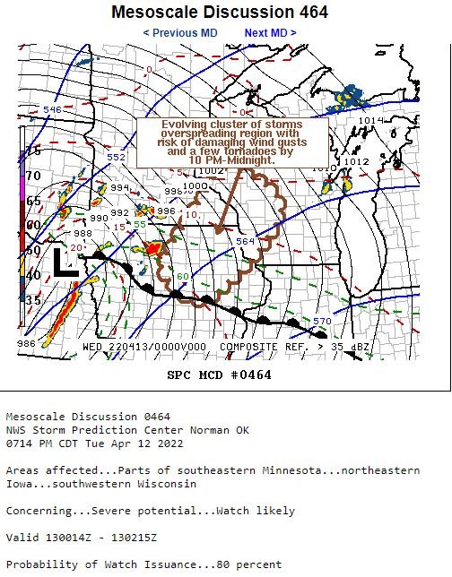
   SUMMARY...The evolution of an increasingly organized cluster of
   storms seems probable this evening, before overspreading the region
   through 10 PM-Midnight, accompanied by a risk for damaging wind
   gusts and tornadoes.

   DISCUSSION...Strong thunderstorm development continues to increase
   in coverage in association with large-scale ascent downstream of a
   deep northeastward migrating surface cyclone.  This is being aided
   by forcing associated with a subtle lead short wave perturbation,
   and includes an evolving cluster of supercells near the Fort Dodge
   IA area.

   As the mid-level perturbation migrates northeast of the mid Missouri
   Valley toward the Upper Midwest through mid to late evening,
   considerable further upscale convective growth will continue to
   ensue.  The evolution of an increasingly organized mesoscale
   convective system seems probable as the environment destabilizes
   coincident with increasing forcing for ascent overspreading the
   region.

   Embedded within strengthening deep-layer ambient mean flow (in
   excess of 50 kt), increasingly widespread damaging wind gusts are
   possible.  A coinciding larger-scale bow structure may evolve in
   radar reflectivities, with embedded supercell structures posing a
   risk for tornadoes, mainly where the apex of the bow intersects a
   northeastward advancing warm front ahead of the surface cyclone.
STORM REPORTS:

STORM PREDICTION CENTER OUTLOOKS:

Content Link Block