
MAY 25TH NEW MEXICO: TERRIFIC SUPERCELL STORM STRUCTURE

Looking right up the first storm updraft as it was developing near Eunice, NM. This cell soon weakened and we bailed on it.
Our storm of the day exploding near Carlsbad, NM. The third straight day we have chased a supercell near Carlsbad!

Storm was starting to mature, moving right at us to the east of Carlsbad.
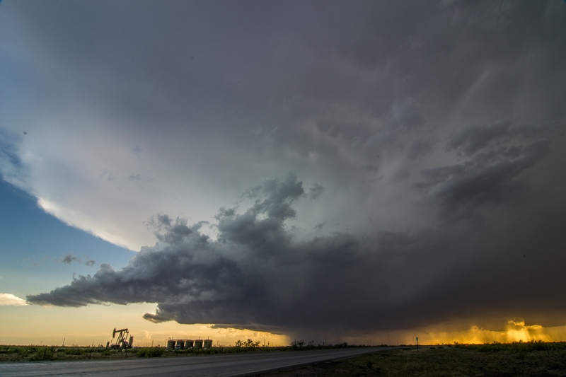
Another shot of the storm with an oil pump and storage containers to the left. Decent inflow bands into this storm and spread out anvil above.

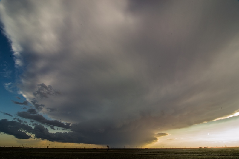
Storm fully mature with beautiful, spiraled updraft and great structure to the west of Hobbs, NM.
Another shot with the setting sun providing some nice backlighting for photos.

A short while later as the severe warned storm held on to the great structure and intense core.

Storm starting to move very close at sunset. Backwards C shape to the base, indicating there is likely a rear flank downdraft cutting in behind this storm.
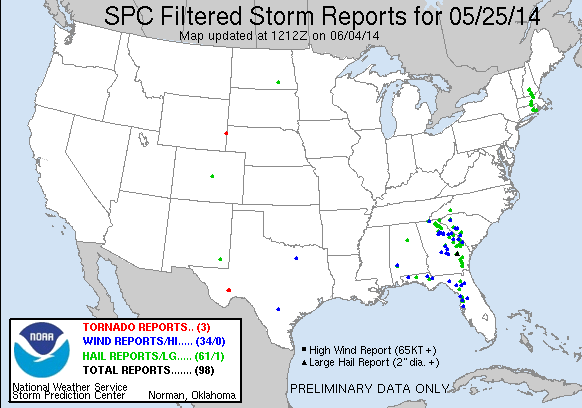
STORM REPORTS:
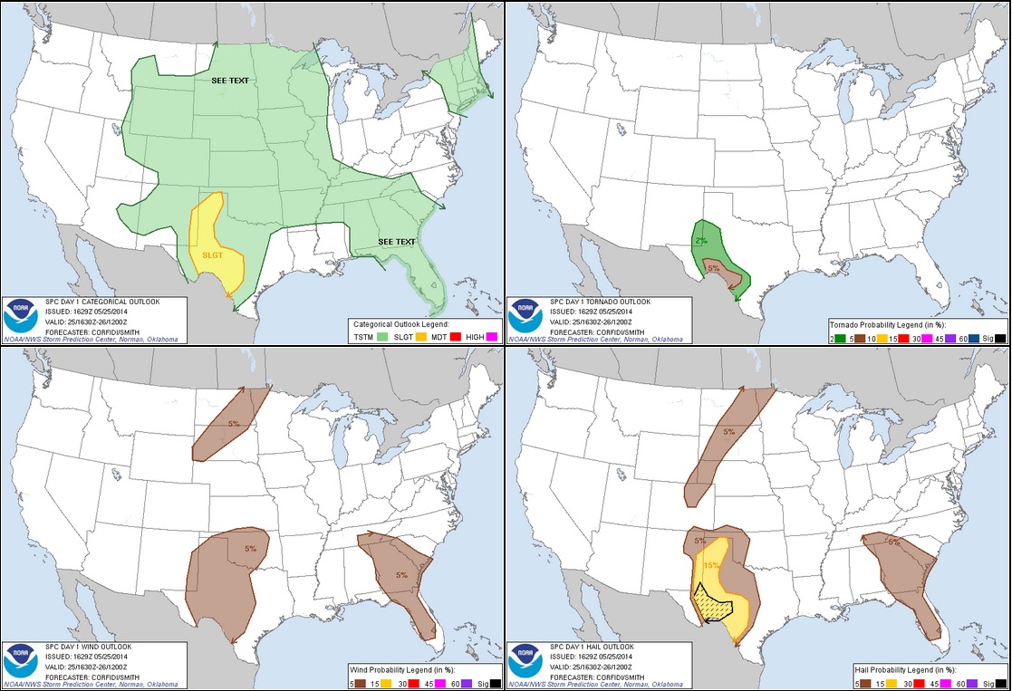
STORM PREDICTION CENTER OUTLOOKS:
MAY 25, 2014 CHASE LOG: NEW MEXICO
Written by Rich Hamel: (www.bostonstormchaser.com/)
This has started to become the “New Mexico Tour”! We left Lubbock with two distinctly different targets for the day: South near Ft. Stockton where the outflow boundaries from the previous night’s convection intersected the dry line, or up near Roswell, NW where the models developed storms out of the mountains late in the day based on upslope flow and residual instability. With the two targets so far apart, we were going to have to commit to one or the other relatively early.
We headed south down to Midland, TX and stopped for lunch at the mall there. At the time, there was a single anchored tornado-warned supercell way down near Marathon, TX spinning away, but we decided it was too far to get to and ignored it. Still not sure if storms would fire in west Texas, we drifted west towards Monahans, by which time conditions were looking more and more favorable in the Carlsbad / Hobbs area yet again so we headed northwest through Kermit, TX and back into NM, stopping at the Allsups in Eunice to assess the situation, then heading west of town to wait for storms to develop. In the distance, we could see that the HRRR was correct about the Roswell target, with 3 cells exploding with rock-hard convection 90 miles north of us, two of which had big overshooting tops over the anvil clouds. We hung around in the gas fields (it’s amazing how much of southeastern NM and west TX are utterly dominated by the gas and oil industry, the whole region, for hundreds of square miles, smells like heavy oil from all the pumps and drilling) until a cell fired right over us. We headed north a bit to get out of the rain, and the storm seemed to be getting its act together with convection rolling over directly above us.
After a few more radar scans though, the storm was clearly not going to make it and we decided to blast north to try and get to the Roswell storms. We headed up Rt.18 through Hobbs and then up towards Lovington and watch as finally the storm that HRRR was predicting to develop over Carlsbad began to materialize, and soon the echo tops were heading for 40,000 feet. We were in easy intercept position so we aborted going after the Roswell storms and headed west out of Lovington, then south on 283 through the gas and cattle fields to get out in front of the storm, which was now right turning directly at us. As we got just east of the storm, it opened up a big hail core and split, with the left cell slowly dying off and the right mover intensifying rapidly with clear evidence of rotation on radar. After a couple of stops to observe the developing storm, we dropped south to Rt. 180 and drove right up to the base of the southernmost cell (after it had split again) between Carlsbad and Hobbs, and were treated to a beautiful structure-fest near sunset as the storm had a classic supercell look, with a corkscrew rain-free updraft, big precipitation core off the northeast, and numerous inflow bands flowing into the storm. The storm was a bit high-based, but at mid-levels it was spinning like crazy. The colors at sunset were spectacular, with the orange of the sunset behind the storm and the ice-blue base of the updraft, with white barber pole looking convection twisting up to the anvil.
After about 30 minutes of watching the beautiful storm, we headed east alongside it to try and get out in front more a more distant look of the structure, but darkness was falling and we eventually decided to go for lightning instead. This was one thing the storm lacked: it was not very electrified. We made a couple of lightning stops along Rt. 180, but the storm was weakening and we soon decided to call it a night. Luckily, our hotel for the evening was in Hobbs, so we were only about 10 minutes away!!
Another fun chase day. 399 miles for a 6 day total of 3062.