
July 14th Southeast Minnesota Storm Chase - The Northfield Tornadoes
07-14-10 CHASE LOG: MN This was a day that many, as well as myself, were hyping for tornado potential and it did not disappoint. MaryLynn and I, as well as our friend Sheena McLain, left Burnsville around noon and headed down I-35 to Faribault, MN to wait for initiation, which was expected during the early afternoon hours. My thinking was to get south of where I thought storms would initiate and approach from the south where we could get a better view and not have to core punch if storms fired quickly. Convection had been firing all morning over the Twin Cities Metro and these storms appeared to lay out an outflow boundary just south of the metro area. Storms fired before 2 PM to the west of I-35 and one storm in particular took off on the boundary, with an echo top that quickly grew to over 55,000 feet. Our plan was to intercept this storm by taking Hwy 19 west of I-35. Unexpectedly, we ran into some road construction near Lonsdale and the storm almost managed to get away from us before we made it through and around the detour and east on Cty Rd 86.
As we traveled on 86, there was a lowering directly ahead that was trying to organize into a wall cloud. This feature did not manage to get its act together but a different wall cloud soon formed to the south of 86, a few miles northwest of Northfield. The wall cloud quickly started to rotate and form a funnel and at this time I called the report into the NWS as there was not a tornado warning on this storm yet. Soon the tornado warning came out and almost instantly the first funnel descended to near the ground around 2-3 miles north of Northfield. It was short lived and we questioned at the time whether it did touch down, but soon got confirmation of several spotter and chaser reports that it indeed was a tornado. The wall cloud quickly recycled and developed another, and larger, funnel 3-4 miles northeast of Northfield that became an elephant trunk and was easily over ¾ of the way to the ground. This also was a confirmed tornado that damaged some buildings and blew over a semi on Hwy 47. We stopped at the intersection of 86 and Hwy 56 as the tornado lifted but with a continued rapidly rotating funnel to near our location before the feature dissipated.
The tornadic storm soon became cut-off from good inflow air by a storm to its south and east and we decided to bail on Hwy 52 to get south of the line of developing supercells. We core punched a few storms with extremely heavy rain and got south of the developing line. Nothing was really looking all that great at this point but there was a new storm developing near Stewartville, MN that was directly south of our location and would be an easy intercept if we went south on Hwy 52 to I-90 east. We eventually did intercept this storm that was moving at 50+ mph near Lewiston and this is where we saw another wall cloud and a short-lived cone funnel. We followed the storm to Winona and watched it race off into WI. Thereafter, another storm fired to our west so we traveled back west on I-90 to intercept the storm near St Charles. This storm had some interesting features but nothing that looked like it would produce so we decided to start heading home for the night.
As we had dinner in Rochester, new storms fired on the cold front and became severe as we left Rochester to the north on Hwy 52. Upon reaching Oronoco, we could see a very low, ground dragging wall cloud that had formed on a cell near Zumbro Falls! This really was a surprise as I was expecting everything to be linear at this point due to the strong southwest surface winds crossing the cold front, but this storm did appear to get its act together and even had a hook signature on radar. We attempted to follow northeast on Hwy 60 as a funnel cloud was reported on the storm. It quickly went linear as we got close and this is where we FINALLY ended the chase.

Flanking towers going up to the southwest of the developing supercell near Lonsdale, MN.
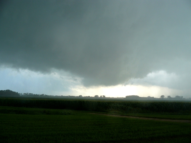
Rotating wall cloud to the east of I-35, 3 miles northwest of Northfield, MN.
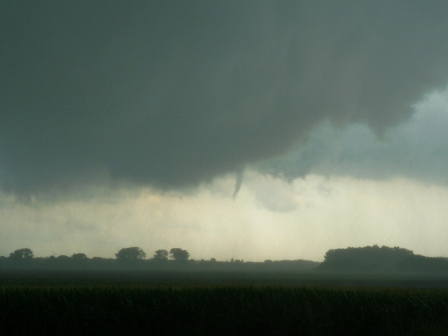
Funnel cloud near the time of the first tornado touchdown 2-3 miles north of Northfield, MN.

Stovepipe tornado ~3 miles north-northeast of Northfield, MN (confirmed touchdown).

Tornado roping out 3-4 miles northeast of Northfield, MN.
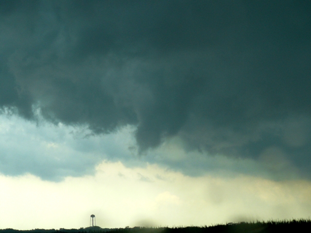
Rapidly rotating funnel cloud near Randolph, MN.

New updraft going up on cell near Dover, MN.

Wall cloud and funnel on cell near Lewiston, MN.
More photos from this day can be found here: http://www.flickr.com/photos/39991047@N02/sets/72157624383030539/
Radar showing hook echo near time of the tornadoes.

Radar velocity image at the time of one of the tornadoes (from NWS Twin Cities). Notice the couplet of inbound and outbound winds to the north of Northfield.
