2013 STORM CHASING HIGHLIGHTS VIDEO


YEAR SUMMARY

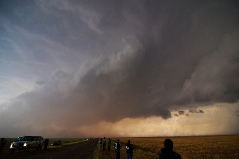
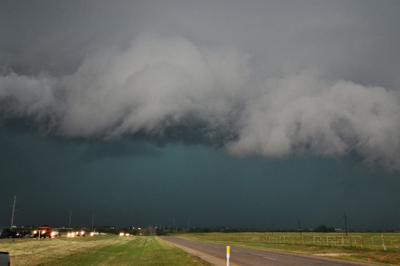
  2013 started off slow, so slow in fact that I did not have a 'real' chase until May 20th!  On that day, I flew into Oklahoma City from Greenville, South Carolina, where I was finishing up working for a PGA Tour tournament.  The atmosphere was already ripe for severe weather, a day after a strong EF4 tornado hit Shawnee, Oklahoma.  I met up with Roger Hill and Silver Lining Tours to be a guide for a 10 day tour, and we decided to pick up what guests were already in town and do an unscheduled chase.  We first got on the storm that would eventually produce the deadly Moore, Oklahoma EF5, but did not want to chase a tornadic storm through the city, so elected to chase supercells down the dryline into southern Oklahoma and just across the border into Texas towards evening.  We did see a weak tornado that day but missed the Moore tornado.  After hearing of the destruction, many of my family members and friends were attempting to contact me, even my work travel agency contacted my office to see if I was ok since they knew that I flew in around midday to OKC.  What a crazy way to start the tour.

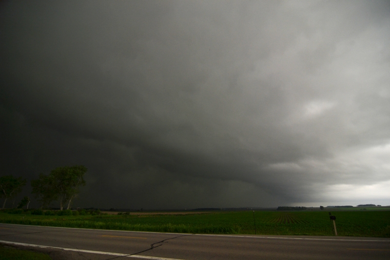
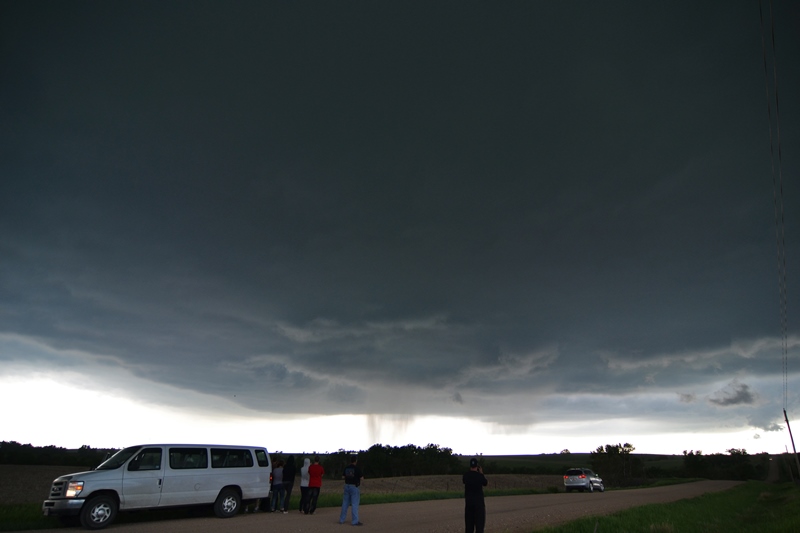
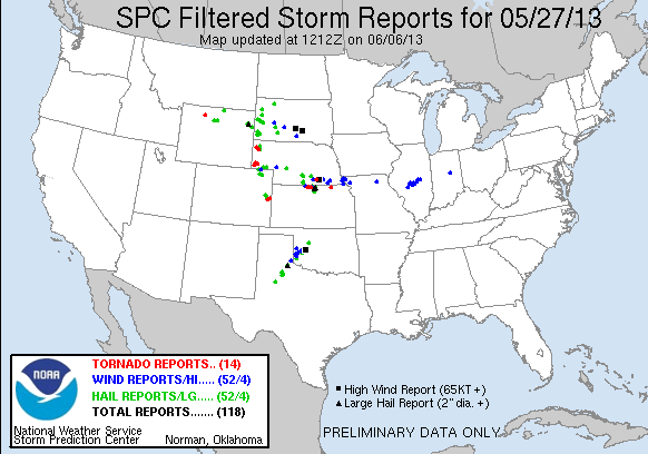
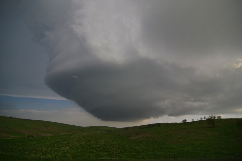
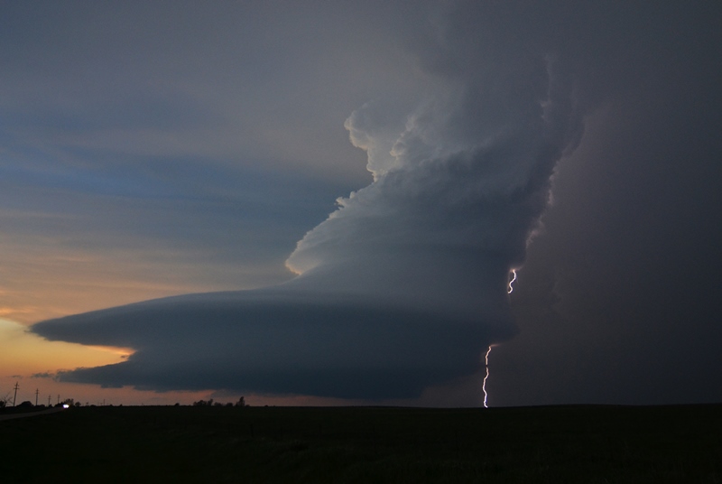
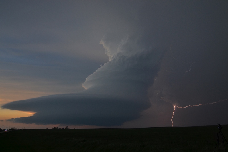
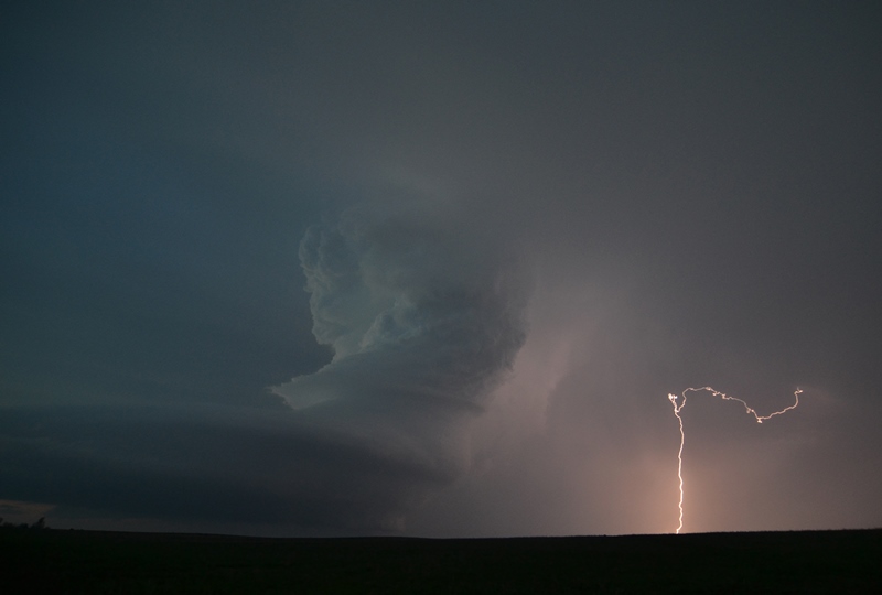
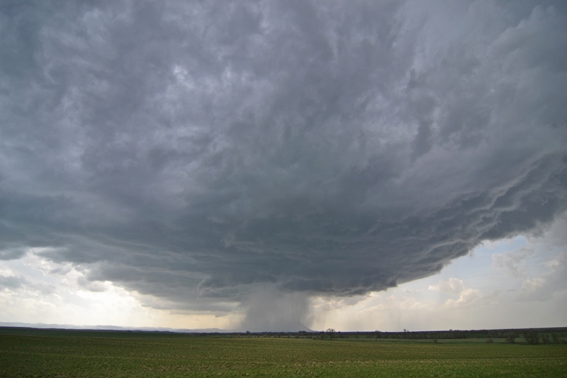
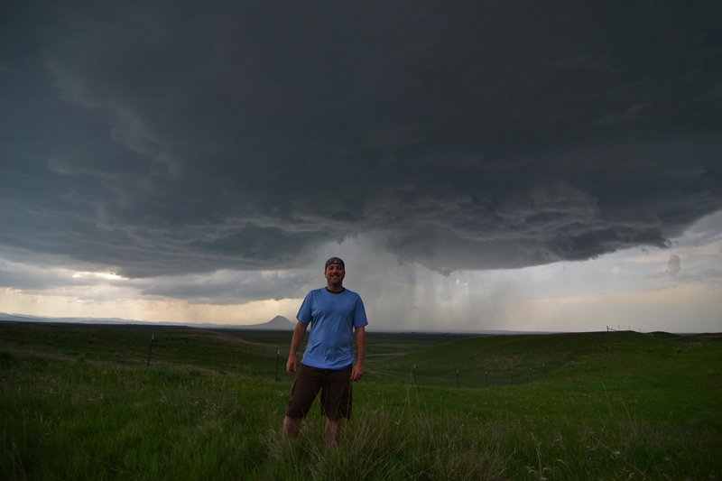
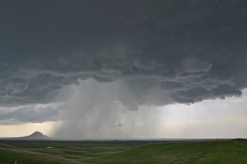
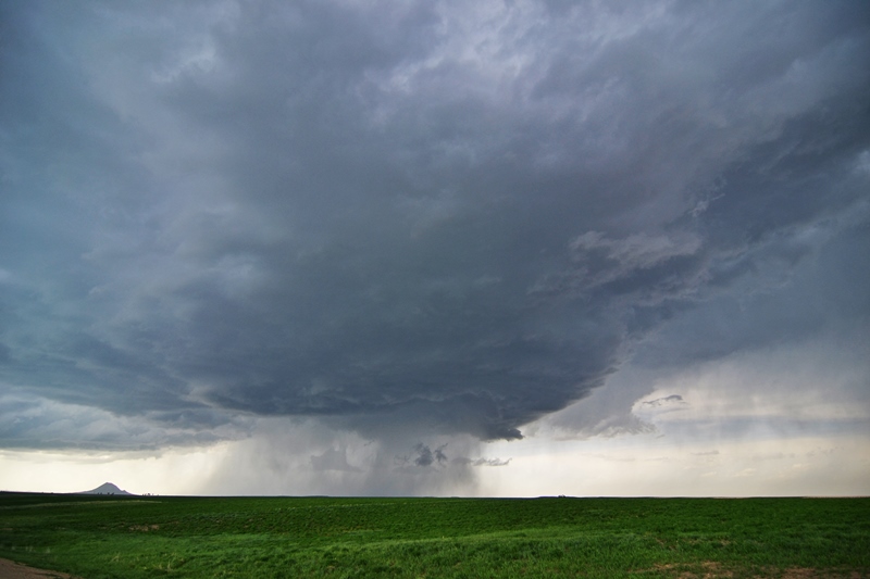
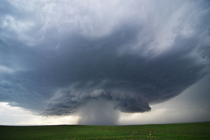
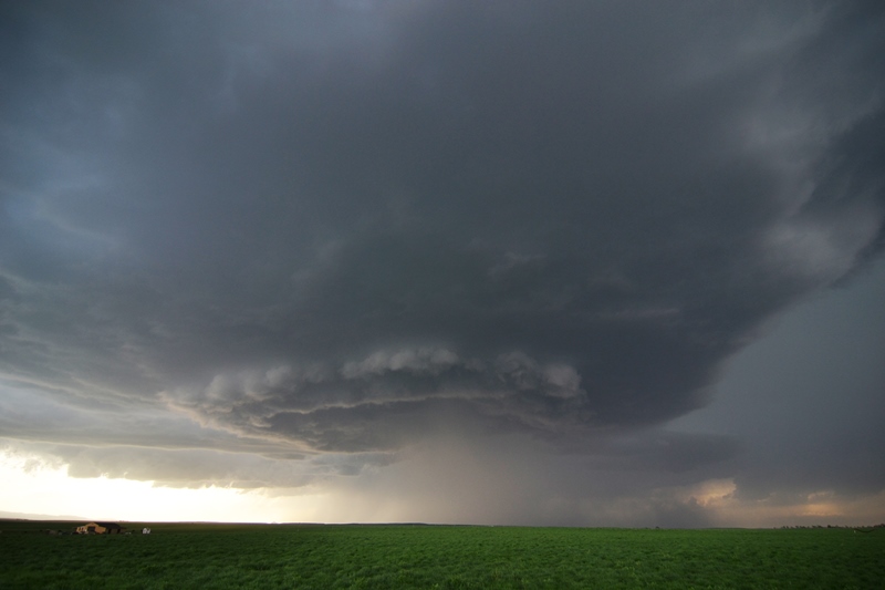
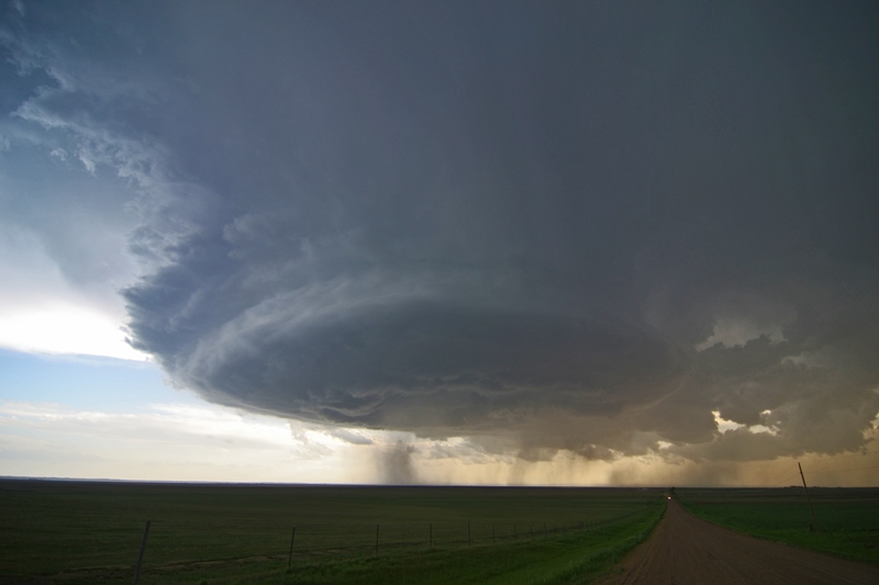
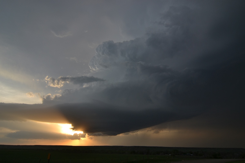
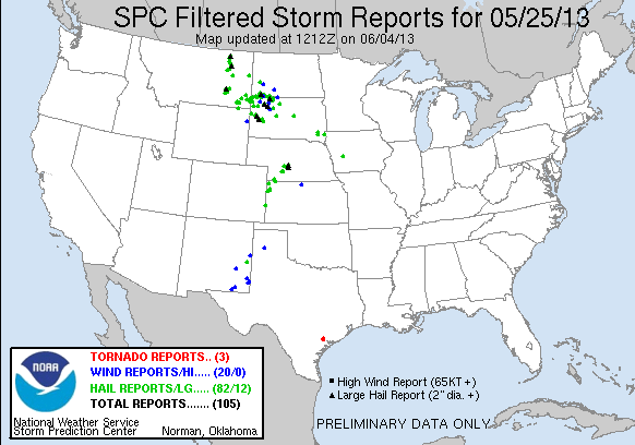
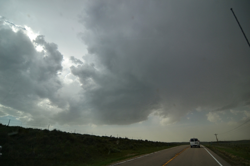
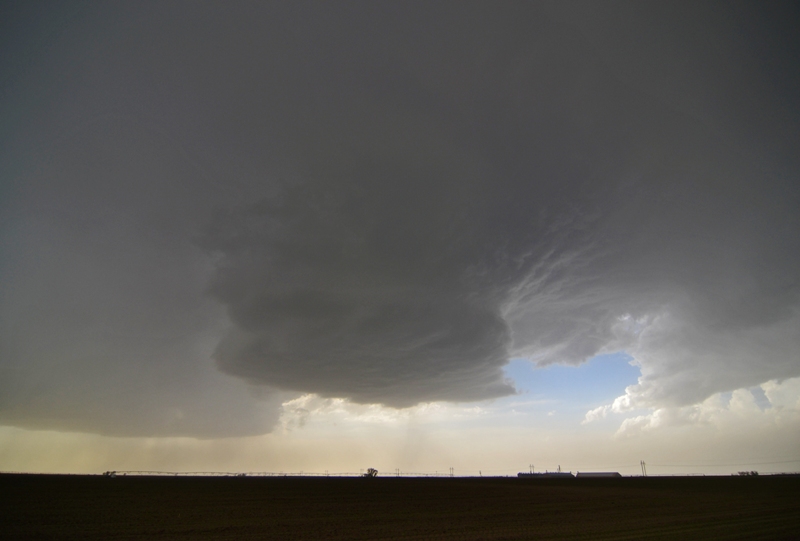
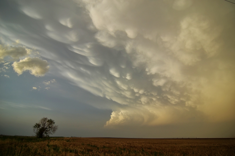
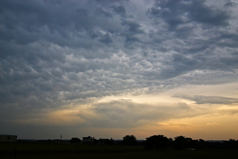
Thereafter, we had kind of a bust day in northeast Texas on the 21st, then set up in the Panhandle for chase on the 23rd.  After an awesome steak dinner at the Big Texan restaurant on the 22nd, we chased a large, dirty supercell storm the day after.  May 24th took us to northeast Colorado and western Nebraska with a low precipitation (LP) storm and tornado warned supercell.  May 25th and 26th were back to back phenomenal storm structure kind of days, some of the best or possibly the best that I have ever seen!  Photogenic, slow-moving storms made for quite the show near Rapid City, South Dakota on May 25th, while incredible, tilted updrafts into strong supercell storms made for a great site and awesome photogenic opportunities on May 26th in central Nebraska.  The video above features some nice time lapse footage from these days.  May 27th featured severe storms, one that nearly produced a tornado.

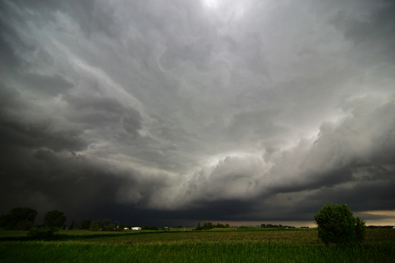
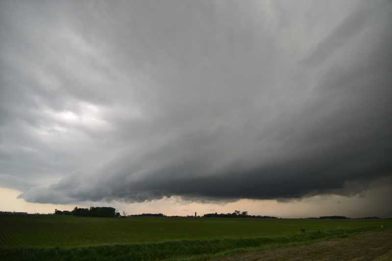
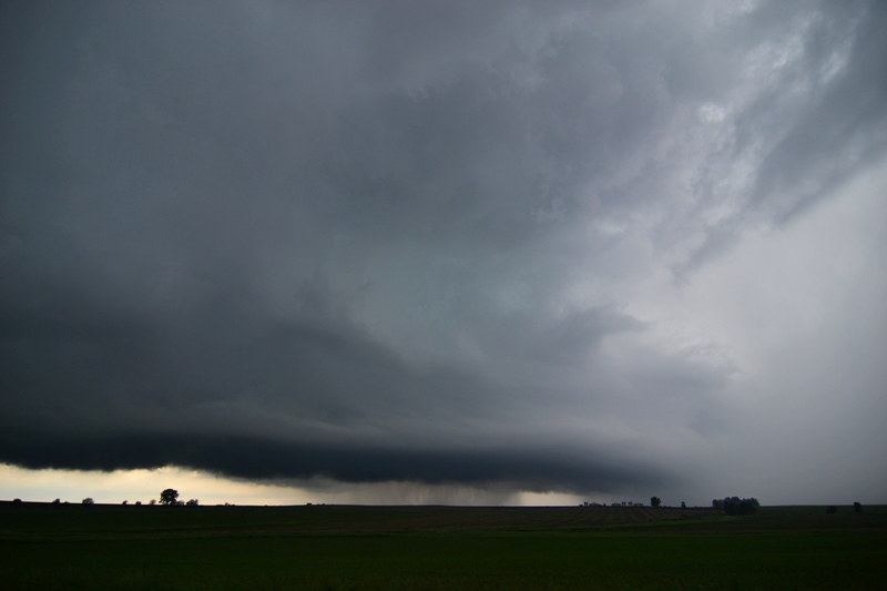
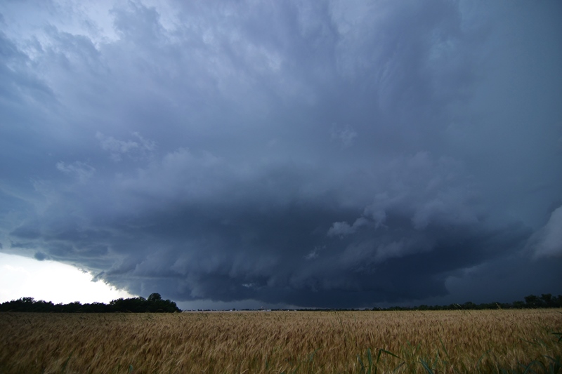
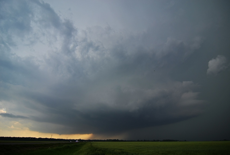
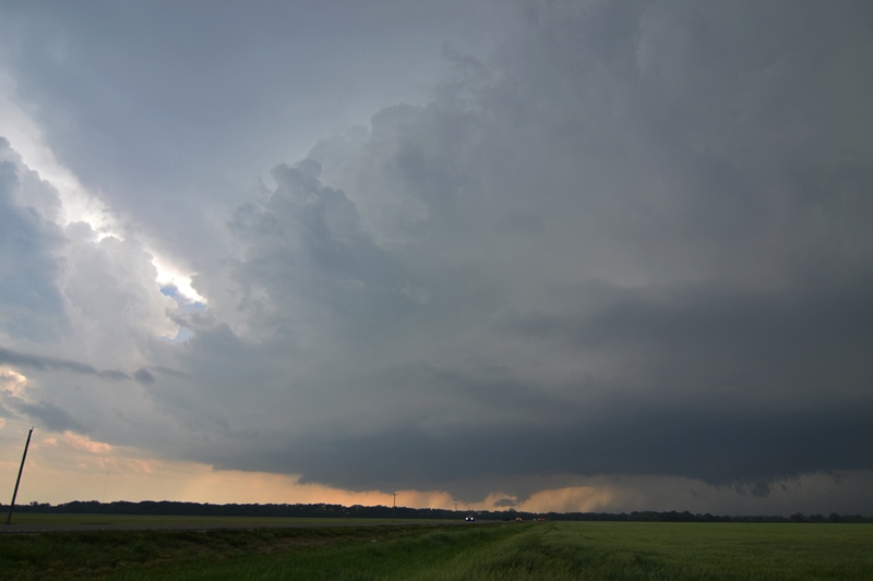
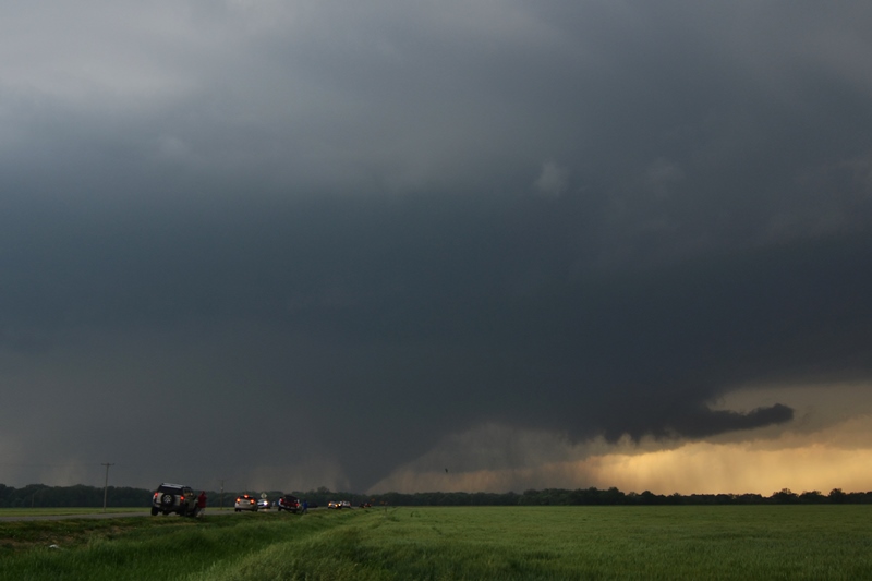
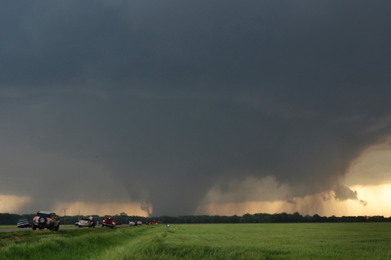
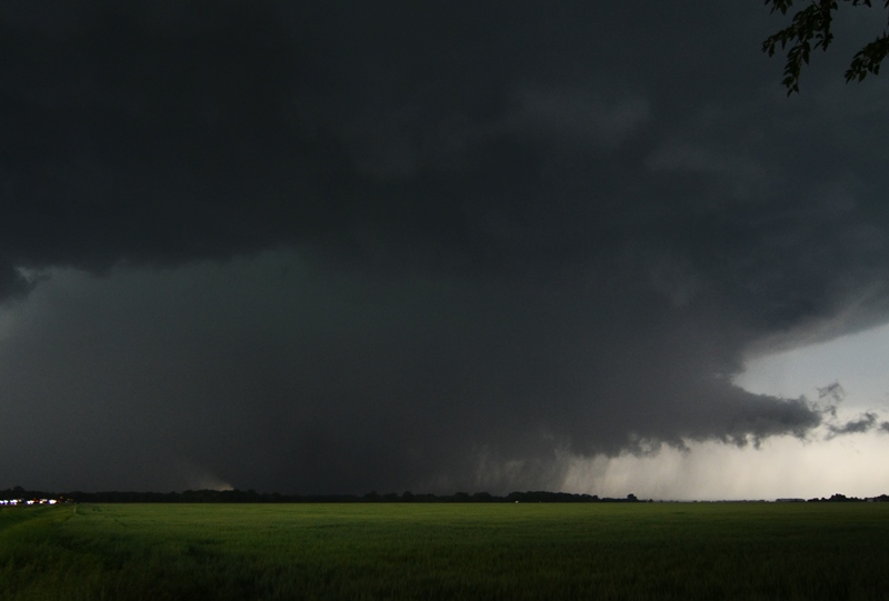
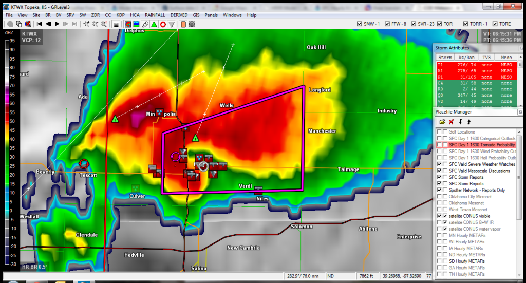
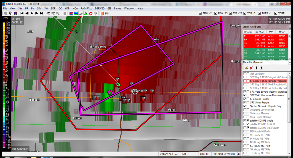
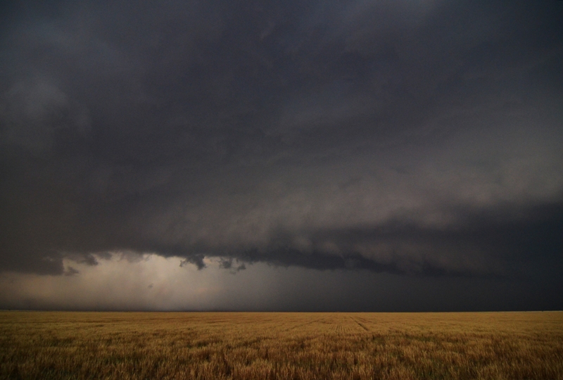
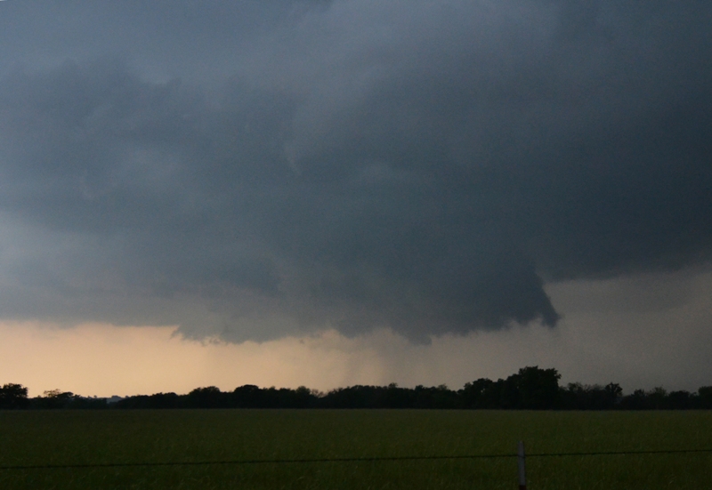
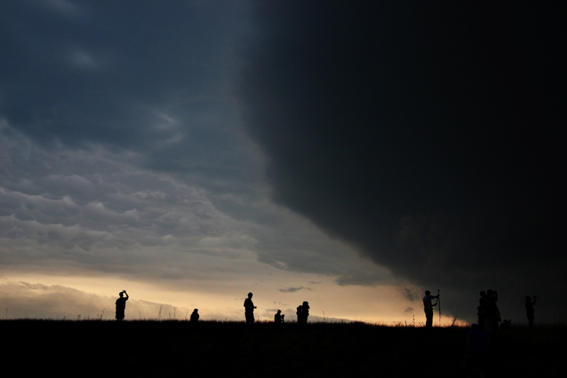
May 28th in Kansas was a site to behold as a storm erupted on a boundary in north-central Kansas, sat in one spot due to weak steering flow aloft, and produced a large, violent EF4 tornado that was nearly stationary for almost an hour!  This incredible tornado was one of the Tornadoes of the Year and one of the best I have ever seen.  We had the privilege of watching this tornado develop, change shapes, and morph from an elephant trunk, to stovepipe, then wedge, right in front of us while not having to move at all.   In fact, we were able to sit with our cameras on tripods and watch the entire supercell and tornado evolution...it was amazing, especially since this tornado did not injure anyone and did not destroy any homes.  We had one down day before we chased again on May 30th in Oklahoma, chasing storms on a dryline and a massive high precipitation (HP) beast at sunset.

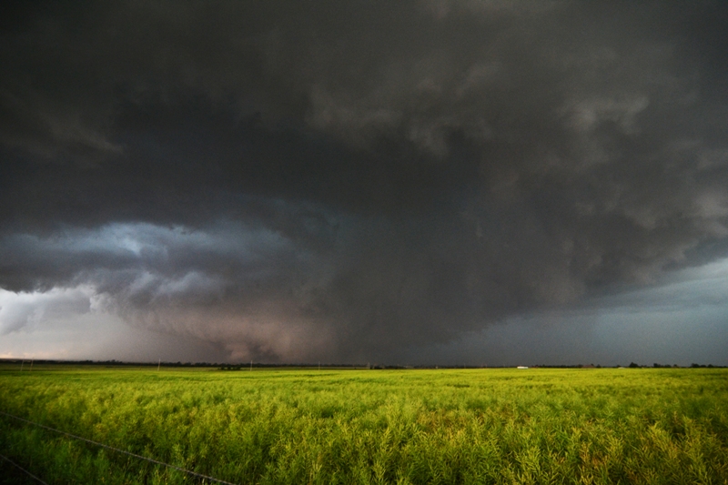
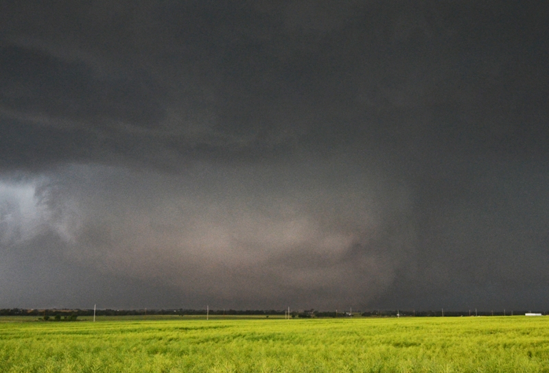
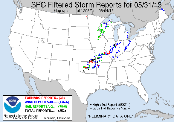
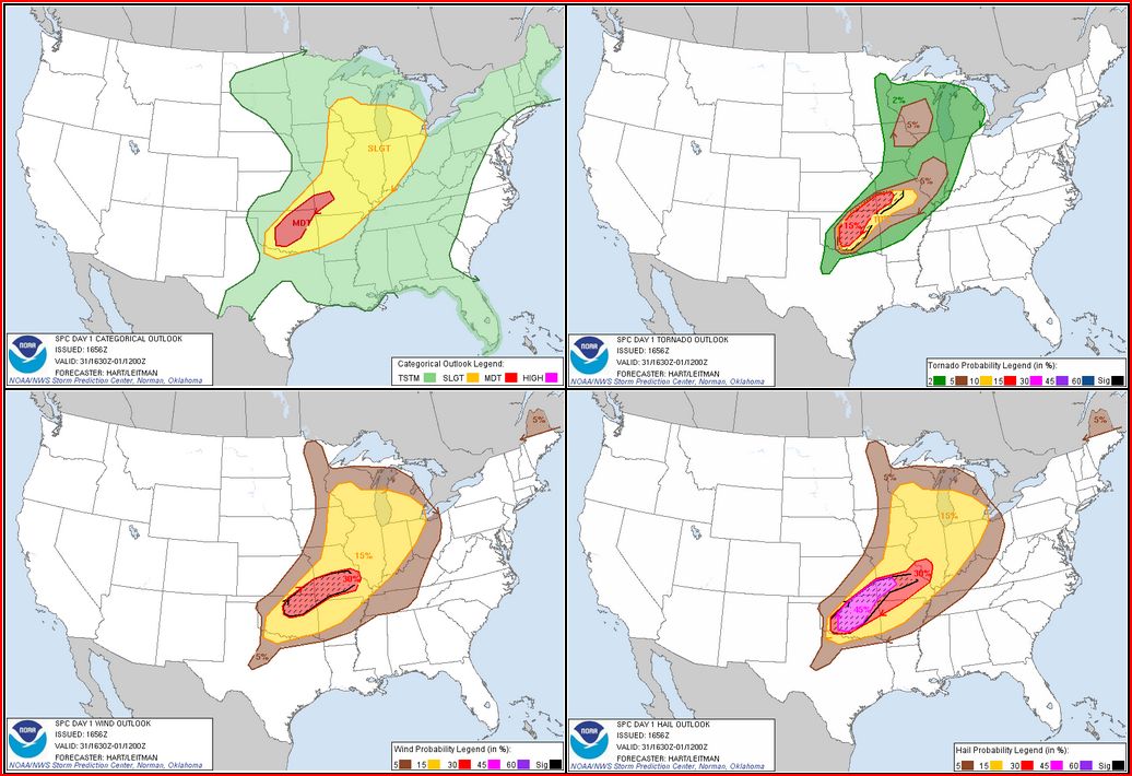
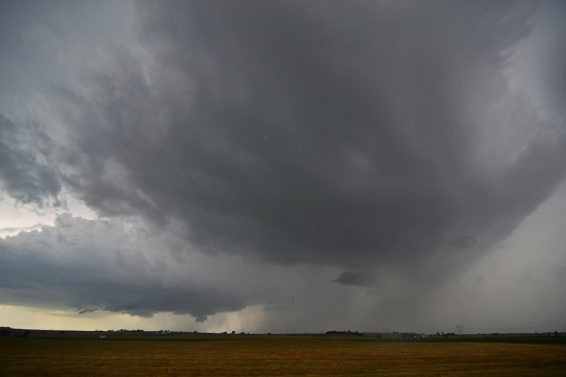
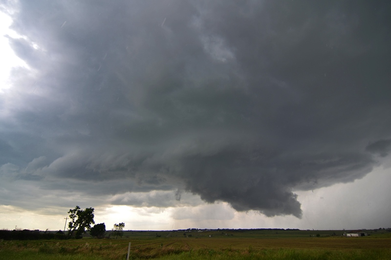
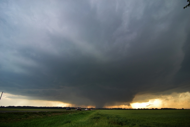
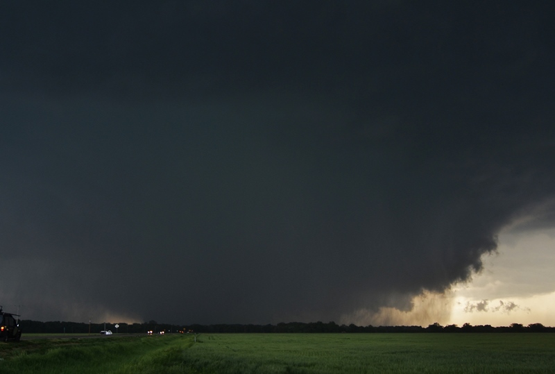
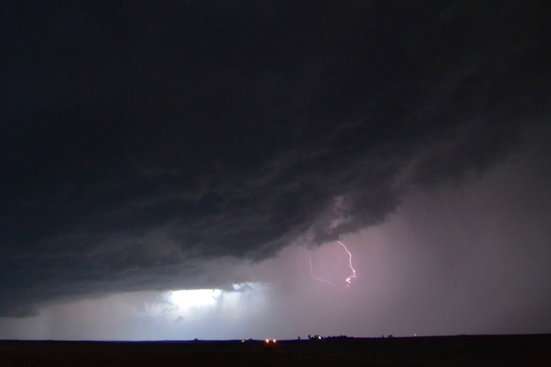
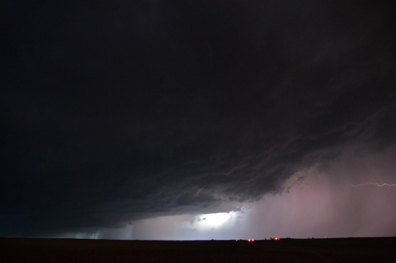
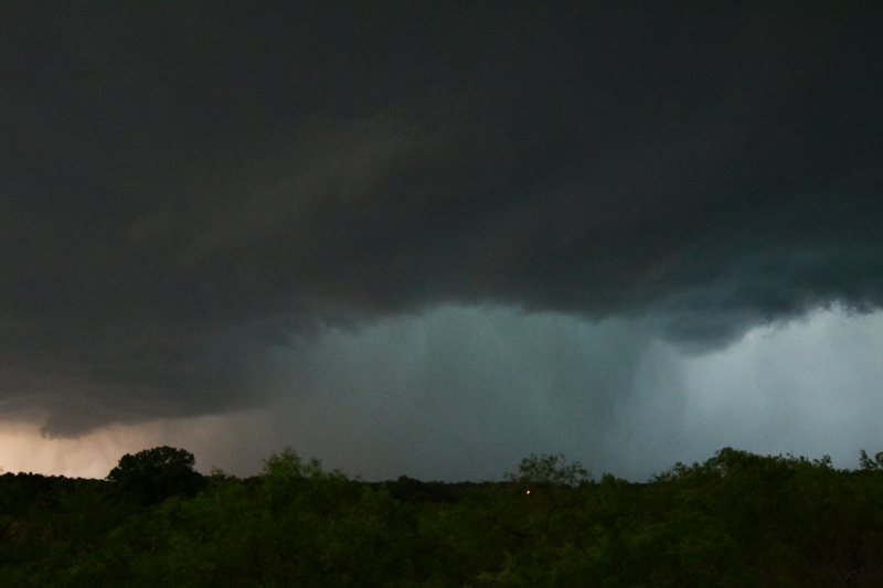
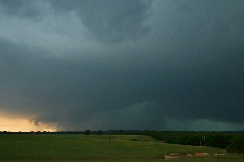
May 31st was the only time that I had ever chased where I thought I might be in real danger.  This was a day after the final chase day of the tour, so I rented a car and chased with some friends.  We set up shop in El Reno, Oklahoma and watched potent supercells develop on the dryline just to the west of Oklahoma City.  Towards the end of the highlights video, you can see the wedge tornado from the southern-most supercell appear on the horizon underneath the storm, and then start to move directly at us.  Thereafter, the second part of the video featured the tornado as it moved to our north and grew to as much as 2.6 miles wide, taking a left turn back north towards the interstate and increasing in speed.  We got out of the way of this large, EF3 tornado but did have the rotating mesocylcone/tornado-warned storm right behind it move over us as we attempted to cross the Canadian River on the southwest side of the Oklahoma City metro area through very heavy traffic.  At this point, the meso moved overhead and the winds switched around to the west and RFD hammered us.  We dodged the third tornado warned storm and finally got around the backside of the training thunderstorms that produced intense flooding through the Oklahoma City area.  I drove all night to get back home to Minnesota after that white knuckle adventure, driving by adrenaline and from what I had just seen.

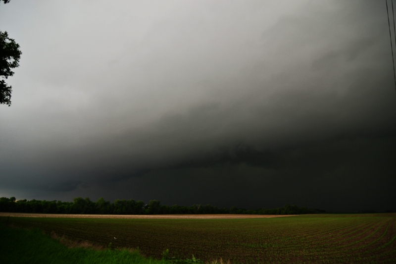
The last few chases of the year were (sadly) in June as the atmosphere shut down for the rest of the summer thereafter.  My wife and I chased 3 tornado warned storms in Iowa on June 12th, but did not see any tornadoes on this day.  The storms were intense though, and we saw a really nice shelf cloud and got in some nickel size hail.  One of the very few tornadoes in Minnesota occurred on June 21st as we chased storms out of South Dakota into southwest Minnesota.  We were able to view a very weak EF0 tornado right in front of us near Tracy, Minnesota.  It wasn't much more than a grand dust devil, but it was still really cool to be that close to what certainly was a tornado.  This is what finishes up the highlights video.

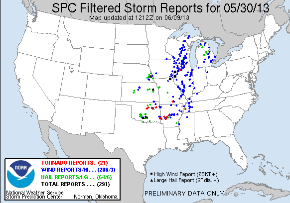
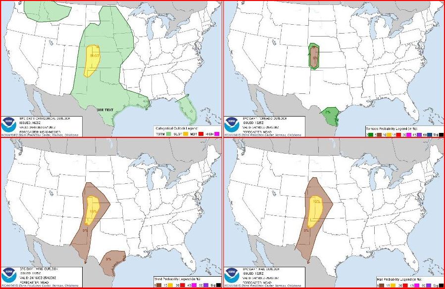
In summary, I managed to see 6 tornadoes this year, 1 EF4, 1 EF3, 1 EF1, 2 EF0's, and the other rating I'm not sure of.  Considering it was a down year for severe weather and tornadoes, I managed to pick some great days to go, some of which featured incredible storm structure and features that made the chases very enjoyable.  Looking forward to chasing storms in 2014!

JUNE 21ST SOUTH DAKOTA AND MINNESOTA - CLOSE WEAK TORNADO

 
DSC_1689-2
DSC_1689-2

Intense storm with high winds and hail about to overtake us from the southwest near Lake Norden, SD.

DSC_1692-2
DSC_1692-2

Ahead of the main line of storms east of Lake Poinsett, SD just across the border into MN.

DSC_1696-2
DSC_1696-2

Looking north at the severe warned, intense line of storms quickly moving to the east as we attempted to stay ahead heading into southwest MN.

DSC_1703-2
DSC_1703-2

Severe warned storm and clearly ingesting tons of low level moisture right into the base near Tyler, MN.

DSC_1711-2
DSC_1711-2

I did not notice this until putting the chase log together, but there is a funnel and even a dirt swirl underneath between the two trees on the left-center side of the image.  This was looking to our southwest, so the tornado was down even longer than I thought.  This was taken shortly before a farmer came flying into the area where we were parked, laying on his horn, and yelling about seeing a tornado.  He was right!

DSC_1714-2
DSC_1714-2

Taken after seeing the weak tornado near Amiret at the storm base that was starting to look a bit more outflow dominant.

DSC_1721-2
DSC_1721-2

Shelf cloud at the end of the chase near Wabasso, MN.

STORM REPORTS:

130621_rpts_filtered

STORM PREDICTION CENTER OUTLOOKS:

Outlooks
Outlooks

JUNE 21, 2013 CHASE LOG: SOUTH DAKOTA & MINNESOTA

  This was one of those days where I almost decided not to go, pulled the trigger to head out, and did not regret the decision.  It’s not too often where I’ll blow off a chase when I have the opportunity and time to do it.  Leading up to this day, it looked pretty decent in regards to supercell and even tornado potential.  Insane instability in the 4,000-5,000 j/kg range was in the forecast ahead of a surface low and south of a warm front from eastern SD into southwest MN, while a subtle shortwave was expected to trigger intense thunderstorms during the afternoon hours.  The caveat was what a complex of morning storms in SD would end up doing as they progressed into eastern SD and southern MN and if this would indeed be the main show, primarily a wind/hail threat with shelf clouds and really low tornado potential.

Wes Hyduke and I left Burnsville, MN around 11:30am and headed west on Hwy 212 towards SD.  On the way, we watched on radar as a complex of intense severe thunderstorms advanced across SD with numerous severe thunderstorm warnings for damaging winds and hail along the storm path.  This was my fear for the day as I thought this would be it, but the line of storms began to break apart into individual storms as it moved into eastern SD.  We were still in MN heading west on 212 when the storms started to become tornado warned.  A mesoscale discussion was issued by SPC at 1:34pm, highlighting an area ahead of these storms and into southwest MN on the northward retreating warm front where severe weather was expected through the afternoon.  A Tornado Watch soon followed at 2:00pm CDT.

As we approached Watertown, SD, tornadoes were being confirmed on the storm near Redfield, SD but there was no way we were going to make it.  Instead, we traveled south on Hwy 81 and west on Hwy 28, intercepting a tornado warned storm near Lake Norden.  This storm was a beast and was starting to wrap a strong and large hook around the core at 50 mph.  The thought was to get to a main road and travel north to stay ahead of the hook and attempt to look into the notch of the storm, but we quickly became overcome by the intense rain core with small hail that packed 60 mph winds as we turned around on Hwy 28 and attempted to get out of the way.  Our route took us on Hwy 28 to the east of Lake Poinsett where the storm became very intense before we finally got to the eastern edge of the core as we entered into MN.  I’m glad we got out of there, as there were extreme high winds in this storm that led to a fatality at Lake Poinsett due to a trailer being lifted off the ground and slammed back down.

We continued to progress east into MN and stair step south towards Tyler, MN where we intercepted the tail end storm on what was becoming a bowing line to the north.  As we got on the storm, you could tell that this was not becoming outflow dominant just yet.  There was a lowering and what soon became a wall cloud as we progressed east on 160th St to the east of Tyler.  The storm was obviously still in a decent low level helicity environment as there was a lot of motion, scud rising and falling, and continued strong inflow into the storm.  As we stopped to watch under a slowly rotating mesocyclone near Amiret, MN and 8 miles northwest of Tracy, a spin-up occurred to our southwest.  We watched as what looked to be a strong dust devil moved to our southeast and then to the east on our road.  It was really cool to get on video what was a weak tornado right in front of us!  We were able to get within about 50 yards, maybe less, before the tornado went into a field to our north and continued on.  This tornado was down for several minutes before we could not see the ground rotation and debris field anymore.  At first, this looked like a strong dust devil or gustnado, but there was definitely a rotating mesocyclone overhead and a funnel that others documented as well, so classifying it as a tornado for sure.  After having this close encounter, we stayed ahead of the storm as we traveled towards New Ulm and it weakened, and then headed for home on Hwy 169 thereafter.

JUNE 12TH IOWA - 3 TORNADO WARNED STORMS

 
DSC_1629-2
DSC_1629-2

Wall cloud on tornado warned storm near Independence, IA right as storm merger was starting to take place.

DSC_1632-2
DSC_1632-2

Storm near Independence, IA while new flanking line towers started to go up.  Nice mammatus on western side of storm.

DSC_1637-2
DSC_1637-2

Heading west on Hwy 20 looking back at our initial storm with new updraft and mammatus near Jessup, IA.

DSC_1640-2
DSC_1640-2

Large rotating, low mesocyclone on tornado warned storm near Allison, IA.

DSC_1645-2
DSC_1645-2

Bowl lowering in the rain shaft to the left of the road on tornado warned storm near Allison, IA.

DSC_1654-2
DSC_1654-2

Lowering on the left side of the photo with noticeable inflow bands feeding into the storm near Shell Rock, IA.

DSC_1665-2
DSC_1665-2

Awesome shelf cloud at the end of the day near Readlyn, IA.

DSC_1669-2
DSC_1669-2

Another shot of the shelf cloud near Readlyn, IA as it was about to overtake us.

STORM REPORTS:

130612_rpts_filtered

STORM PREDICTION CENTER OUTLOOKS:

Outlooks
Outlooks

June 12th, 2013 CHASE LOG: IOWA

  This was an event that I had no intentions on chasing as the thought was that the system would be too far east and would be more of a damaging wind/squall line threat.  But after looking at things around the lunch hour and seeing a favorable tornado set-up, I decided to make a run for it.  There was a deepening surface low over central IA and a frontal boundary eastward into northeast IA and along the IL/WI border.  The environment was characterized by moderate to strong instability with MLCAPE ranging from 2,000 j/kg over central IA to 4,000 j/kg over eastern IA and northern IL.  Deep layer shear across the area was in the 50-60 kt range and low level shear was fairly impressive, although surface winds south of the boundary were turning more southwesterly leading up to storm initiation.  An upper level impulse approached from the west, which allowed storms to initiate across central and eastern IA by mid afternoon.

As we progressed south along Hwy 52 from MN into northeast IA, SPC issued a PDS Tornado Watch at 1:50 PM CDT, highlighting the risk for strong tornadoes with any discrete storms initially and then a bow echo/derecho scenario setting up into the overnight as storms progressed further to the east.  Already behind the game, we encountered numerous areas of road construction that slowed us down along the way as we headed due south on Hwy 52 from Decorah down to West Union, IA as storms were already developing along the boundary just to the north of Hwy 20.  We finally were able to get on our first storm, which happened to be tornado warned, on Hwy 150 north if Independence.  This storm had a nice wall cloud on it, but struggled after merging with another cell to the south.  We waited in Independence to see what would happen after the cell merger; all the while a storm near Hampton to our west near I-35 was producing multiple elephant trunk tornadoes.  This was very frustrating as we were not able to make it to these storms that happened to be right on the triple point.  I felt like I made a mistake in not going further west, directly towards the triple point, but I did think the low would move along the boundary, which it didn’t, and the environment further to the east appeared to be much better than the western environment.  Lesson learned: Never doubt a triple point storm!  They just happen to produce magic, even if you don’t expect it.

Anyways,  back to the storm we were on near Independence…it could not get its act together after the cell merger and echo tops continued to drop and the radar presentation was looking horrible, although the storm was photogenic as we watched in a gas station parking lot and then as we traveled west on Hwy 20.  We did bail on this storm and got on another tornado warned storm just to the northeast of Waterloo.  This storm also had a really nice, ground dragging lowering on it, but also weakened soon afterward.  At this point, we were getting quite frustrated as it seemed like storms were weakening right as we got on them.

Our last effort came with yet another tornado warned storm we intercepted between Allison and Shell Rock.  We came upon this storm with a large, rotating mesocyclone southeast of Allison.  At this point, I thought this was this was the storm that was going to give us our tornado.  We had strong inflow, a couple nice inflow bands, and a slowly rotating mesocyclone and the storm had a solid 55k foot echo top.  We followed the storm as it produced a rotating wall cloud south of Shell Rock, but eventually it began to gust out and produced a beautiful shelf cloud near Readlyn.  At this point near sunset, the show was over so we let the storm core us as we sat in a church parking lot in Oran and encountered quarter size hail in the process.  Although no tornadoes and a typical letdown in eastern IA, it was fun considering that we were not even expecting to chase in the first place!

MAY 31ST OKLAHOMA - THE EL RENO EF3 TORNADO

 
DSC_1592-2

DSC_1592-2

First getting on the approaching storm roughly 3 miles southeast of El Reno, directly east-northeast of the already large tornado.  Tornado tough to pick out at the time due to what looked like a large hail/rain core underneath.

DSC_1594-2

DSC_1594-2

On the north side of the storm, well defined feeder inflow bands sucking in the rich low level moisture.  Even mid-level moisture bands can be seen spiraling into the intense supercell.  Tornado on the left underneath the storm updraft.

DSC_1595-2

DSC_1595-2

Can clearly pick out the wedge tornado underneath the impressive structured supercell at this time.

DSC_1597-2

DSC_1597-2

Taken over my right shoulder as we were bailing south to get out of the way.  Stopped only for a brief moment to look back and snap the photo as this was the closest we came to the monster tornado.

DSC_1598-2

DSC_1598-2

Tornado begins to get even larger and take a hard left turn towards I-40 as we watched from SW 15th St and Evans St.

DSC_1602-2

DSC_1602-2

Another shot looking north-northwest as the tornado was starting to move by us and go over I-40, becoming even larger and picking up speed in the process.

DSC_1604-2

DSC_1604-2

Had to crank up the contrast here, but I believe this is close to when the tornado was at its largest.  Reported as large as 2.6 miles wide!  Notice the entire mesocyclone now on the ground.

DSC_1606-2

DSC_1606-2

Another shot of the incredibly massive tornado in the distance as it was moving away and wrapping into the supercell.

NWRT_20130531_ElReno

NWRT_20130531_ElReno

Incredible phased array radar imagery of the tornadic supercell that spawned the powerful, massive tornado.

raxpol

raxpol

RAXPOL radar imagery.  Notice in the DBZ and VEL imagery how clearly you can see the main tornado and the satellite tornado.  ZDR clearly shows large debris ball with foreign objects to the radar indicated in green and blue.

STORM REPORTS:

130531_rpts_filtered

130531_rpts_filtered

STORM PREDICTION CENTER OUTLOOKS:

5-31-13 Outlooks

5-31-13 Outlooks

MAY 31, 2013 CHASE LOG: OKLAHOMA

Rest in Peace and God Bless Tim and Paul Samaras, Carl Young, and others who lost their lives to this tornado.

  The El Reno Tornado will go down as one of the most remembered tornadoes in history and the largest tornado ever recorded to date.  This tornado was originally classified as an EF-5 with winds of 296 mph based on mobile radar, but has since been corrected down to an EF3 based on damage assessments.  It was also a record 2.6 miles wide at its largest point.  It grew from 1 mile wide to 2.6 miles wide in 30 seconds!  What a monster.

May 30th was my last day of chasing as a tour guide for Silver Lining Tours, but thinking Friday was going to be a big day near Oklahoma City, I decided to stick around and chase with some friends.  I met up with Peggy Willenberg, Melanie Metz, Kevin Van Leer, and Kate Demchack in El Reno, OK as the first cumulus towers began to develop on the intersection of a stalled front and dryline.  The environment was extremely unstable with 4,000+ J/KG of MLCAPE, temperatures in the upper 80s, and dewpoints in the middle 70s.  In addition to very steep lapse rates supporting large hail, surface winds were backed out of the south-southeast with 50 kts of effective shear and decent mid and upper level wind speeds, supporting a substantial tornado threat with any supercells that developed within this environment.  As a result, the Storm Prediction Center issued a Particularly Dangerous Situation (PDS) Tornado Watch at 3:30 PM CDT.

Initially, there were 3 intense storms that developed on this boundary intersection but these congealed somewhat, which made me think that maybe this day was not going to turn out to be a big tornado day after all, especially since the few days before did not work out as planned.  We first went west on I-40, then north on Hwy 270 towards the northern storm with 60k foot echo tops.  At this point to the north of Calumet, we could see all 3 storm bases as the storms were intensifying and starting to produce a few lowerings.  When the storms started to congeal, we decided to head east on 248th St NW towards Okarche, and then get ahead of all of the storms on the northwest to southeast angled road of Hwy 3 towards Yukon.  I did contemplate turning around and heading back south on Hwy 81 to intercept the tail end storm, which was starting to look the best, but this decision not to do this turned out to be a very good one.  We went south on Hwy 4 in Yukon and then Hwy 92 south of I-40 as the southern storm became tornado warned.  Already traffic was starting to get bad as we were caught in some rush hour congestion and we slowed to a crawl as we attempted get south.  I noticed an option to head west, directly at the developing hook echo, on some gravel roads so I took it.  This ended up working out perfectly as there was little to no traffic and open roads for us to work with as we approached the storm.  We ended up stopping near the intersection near Reuter Rd and Evans Rd, roughly 3 miles from the approaching tornado that we could see was rain-wrapped but visible, along with a satellite tornado that you can see in the video to the right side of the main tornado.  I had enough time to take some photos and video, but clearly this was not a storm to mess with as it was getting larger by the minute and moving right towards us.  I decided to bail south on S Evans Rd and east on SW 15th St to watch the ever growing and intense wedge tornado pass by.  This is when the tornado unexpectedly quickly grew and made a sharp shift to the north towards I-40 and unfortunately injured and killed several chasers in the process.  As I recorded the tornado on my camera, I walked away for 30 seconds, came back and the whole tornado to my amazement had exceeded the viewing pane.  It was incredible to see a tornado grow that large in that short of time.  It was hard to get real excited about this strong and massive tornado, knowing there were probably people and homes in its path, especially since it was approaching Yukon.

After leaving this tornado, we paralleled the storm to the east on SW 15th St into the south part of Yukon, seeing power flashes occur to my northeast along the way.  This is when the traffic started to really become a problem.  I attempted to bail south and get out of the way of the second and third couplets that were on storms approaching from the west and taking a dive to the southeast.  I became stuck in bumper to bumper traffic trying to get across one of the few routes across the Canadian River (S Mustang RD to Hwy 4) in Southwest Oklahoma City.  This is when a couplet on radar passed just behind me and my car was slammed by roughly 50 mph RFD winds and people really started freaking out.  It was mass chaos as people started abandoning their cars and running for any shelter that they could.  There were vehicles slamming into other vehicles, people getting rear-ended, and a total loss of laws and rules that you would see more in a movie rather than playing out in front of you in real life.  I witnessed several accidents and people just kept driving, leaving others stranded with disabled vehicles.  After that debacle, they police started opening up all lanes across the river and south and not allowing traffic to go back north so we got out of there and over to Tuttle on Hwy 37 and then south on Hwy 93 before the next and stronger couplet on the third storm reached the area.  I can honestly say that this is the first time that I thought about leaving my vehicle to find shelter from a tornado as we were not sure if we could beat the third couplet due to the horrendous traffic and almost tried getting into a church.  It was the first time that I thought I was trapped in a bad situation with a tornado and no place to go…definitely a scary ordeal.  We made it around the storms to the west and then back north on Hwy 81 where we drove through a lot of flash flooding and a large damage path between Union City and El Reno.  Here is where there were overturned cars, some thrown well into fields away from any roads, and police and ambulance lights as far as you could see to the east.  It was a very eery scene to a scary and deadly day.

MAY 30TH OKLAHOMA - DRYLINE SUPERCELLS & MASSIVE BEAST AT SUNSET

 
DSC_1524-2
DSC_1524-2

Lowering on the left, underneath the developing supercell near Blanchard, OK.

DSC_1529-2
DSC_1529-2

Rising, twisting tail cloud into the developing wall cloud on the storm near Blanchard, OK.

DSC_1534-2
DSC_1534-2

Another shot of the rising scud into the developing wall cloud.  Storm starting to get cylindrical base to it.

DSC_1539-2
DSC_1539-2

This got really interesting at this point of the storm.  Lots of rotation noted as the storm pulled in moisture-rich low level air.

DSC_1542-2
DSC_1542-2

Still an interesting lowering on the storm and well defined inflow bands as we approached Dibble, OK.

DSC_1550-2
DSC_1550-2

Nice look to the storm near Dibble, OK.  At one point, it looked like a little funnel-looking thing underneath, but could not confirm.

DSC_1563-2
DSC_1563-2

Near Lindsay, tornado warned supercell was nearing full maturity.

DSC_1571-2
DSC_1571-2

Storm taking on a liberty bell shape, but looks to be starting to gust out at this time.

DSC_1578-2
DSC_1578-2

Tight, little, but intense updraft near the Red River in southern OK.

DSC_1583-2
DSC_1583-2

Massive beast of a storm approaching sunset near Pauls' Valley, OK.

DSC_1589-2
DSC_1589-2

Looking underneath the shelf of the outflow dominant HP supercell near Paul's Valley, OK.

STORM REPORTS:

130530_rpts_filtered

STORM PREDICTION CENTER OUTLOOKS:

SPC Outlooks
SPC Outlooks

MAY 30, 2013 CHASE LOG: OKLAHOMA

Written by Rich Hamel (http://www.bostonstormchaser.com/)

  This was the last day of Silver Lining’s Prime Time Tour.  Another moderate risk day and, since it was Day 10 and we were already at the host hotel, we were able to leave our stuff at the hotel and just bring our chase gear with us.  Being in our target area already, were able to loiter around Oklahoma City for a lot of the morning and early afternoon as we knew the storms would initiate relatively close to the city, starting to the north near Enid and then building south roughly along I-44 towards Lawton along the dryline.  After lunch and more waiting, the first storms fired and we headed southwest on I-44 as Tornado Watch was issued at 12:55 PM CDT.  We were immediately posed with a choice between a more northern storm up near El Reno that looked better on radar, and a younger storm to the south coming up towards Chickasha that was in what appeared to be in the area with the better shear profile.  The issue with the northern storms, we feared, was that they would become linear pretty early, merging with an MCS that was already active in Kansas.  This did turn out to be true, though the tail end storm hung together longer than we expected, and much later that evening produced a tornado far to the east in Broken Arrow near Tulsa.  We stopped at the rest area near Chickasha for a while trying to decide, and then, with the Chickasha storm clearly visible with a broad base and long inflow band to our south, we decided to go after that one, quickly getting through Chickasha and towards Anadarko on Rt. 62.  Almost immediately the storm generated a solid wall cloud with rotation as we watched it move by to our northwest, but it never seemed to generate enough focus at the lower-levels, a common theme for the day.

We followed the storm northwest on Rt. 277 towards Blanchard, and it looked like it was ready to tornado at one more point as we stopped for a while east of Dibble (while the locals got ready to head into their storm shelters), but it again never quite got the focused rotation needed to tornado, and we were soon drawn south on Rt. 59 through Lindsay towards the next storm, as there were now a number of isolated supercells to our southwest in a line all the way down to the Red River.  After dropping south on Rt. 76, we were soon retracing our route from the Moore tornado day and heading west through Bray to just east of Marlow, where we intercepted another storm with huge hail and rapid rotation that was turning hard right and coming right towards us!  We stopped several times, staying just ahead of the core, and eventually ran south on the exact same road we’d seen the brief tornado on east of Bray on the Moore day.  We stayed out in front of this storm, which had morphed into a high-precipitation hail storm with baseball-sized hail reported, all the way down to Tatums, where we again stopped and watched the big, teal glowing core pass us to the north, all the while looking to two more supercells, that were alternately being tornado warned, down towards the Red River to the south.  Another theme of the day was constantly being torn between storms: From one radar scan to the next we’d be drawn towards a different storm, and every time we left one, it would seem to briefly cycle back up and tempt us to turn right back around.

Again the pattern repeated and after heading south through Fox then east on Rt. 53, we jumped on I-35 and headed south towards Marietta near the Texas border to intercept the last two storms in the line that were right along the Red River.  Heading west out of Marietta, we stopped near Falconhead, OK and watched a textbook LP supercell just to our north, with almost perfect LP storm structure.  It was clearly shriveling up not long after we arrived though, and we decided to head back north towards the hotel to intercept another big storm up there along I-35 on the way.  First, however, as we headed east, the last supercell in line came across the river, and even though it looked to be dying, it was still tornado warned so we turned around and headed through the core just west of Falconhead, getting heavy rain and wind but only the smallest amount of hail.  We turned around and headed back to I-35 to a pretty funny sight: what was left of that storm by the time we got on the highway was just the littlest poof of an updraft attached to what could be barely described as a tiny little anvil on top.

Heading back north, we were faced with a huge HP supercell coming across the highway.  The structure as we neared the storm at dusk was amazing, mostly because it was just so incredibly big!  The base of the storm seemed to stretch on for miles, with a giant rear flank inflow band to the left and a huge cow-killer shelf cloud in front.  With structure that good, we had to stop briefly south of Davis, then were able to split between two big cores as we crossed under the storm near Paul’s Valley.  Finally, after a dinner stop in Purcell (Braum’s!) we headed back to the hotel, completing the tour.

Lots of storms on this day, but the low-level shear just didn’t get it done. I don’t think I’ve ever chased so many tornado warned storms on the same day without any of them even managing so much as a decent funnel cloud!  There were virtually no tornadoes in the moderate threat area for the day, while far to the north where nobody would have expected and nobody was chasing there were a number of them up in Nebraska.

MAY 28TH KANSAS - THE BENNINGTON EF4 TORNADO

 
DSC_1395-2
DSC_1395-2

Supercell storm beginning to get its act together near Bennington, KS.  Inflow bands becoming more defined in all directions.

DSC_1400-2
DSC_1400-2

First funnel forms at 5:31 PM CDT as we watch a couple miles to the east.

DSC_1406-2
DSC_1406-2

After the funnel, a lowering forms underneath the updraft as inflow into the storm strengthens, indicating increasing tornado potential.

DSC_1411-2
DSC_1411-2

Moisture rich inflow air being sucked right into the action area underneath the storm updraft as wall cloud forms.

DSC_1419-2
DSC_1419-2

The tornado first forms at 5:47 PM CDT.

DSC_1421-2
DSC_1421-2

Tornado getting larger with inflow surging in from right to left.

DSC_1429-2
DSC_1429-2

Thick cone tornado underneath rapidly rotating mesocylone.  Tornado has barely moved.

DSC_1443-2
DSC_1443-2

Well defined and strong stovepipe tornado at this point.  Condensation surging up the left side of the tornado.

DSC_1446-2
DSC_1446-2

Zoomed out view showing the incredible storm structure and the stovepipe tornado.

DSC_1450-2
DSC_1450-2

Another shot of the tornado at 5:54 PM CDT.

DSC_1460-2
DSC_1460-2

Tornado becomes rain-wrapped at 6:02 PM CDT.

DSC_1466-2
DSC_1466-2

Tornado getting back out of the rain at 6:03 PM CDT.

DSC_1467-2
DSC_1467-2

What an awesome storm and tornado!  Tornado and storm has not moved hardly at all while we have been watching.

DSC_1481-2
DSC_1481-2

Wedge tornado!

DSC_1483-2
DSC_1483-2

Another shot of the wedge tornado with heavy core to the left and inflow tail to the right.

DSC_1490-2
DSC_1490-2

Transitioning to a big high precipitation (HP) supercell as the tornado becomes rain-wrapped.

DSC_1497-2
DSC_1497-2

Tornado finally ended after nearly an hour!  New wall cloud forming while an attempt to produce another tornado ensues.

DSC_1508-2
DSC_1508-2

Incredible structure to this supercell with long, striated inflow bands around the mesocyclone and wall cloud underneath.

Bennington, KS Radar

Massive hook echo on the storm while we sit directly east of the notch.  Our location is plotted as the white circle with a dot in the middle.  We sat in the same spot the entire life cycle of the tornado and afterwards as the entire storm and tornado hardly even moved!

Bennington, KS Radar3

Velocity couplet showing the tornadic circulation relative to your position as plotted by the white circle and dot.

STORM REPORTS:

130528_rpts_filtered

STORM PREDICTION CENTER OUTLOOKS:

Capture
Capture

MAY 28, 2013 CHASE LOG: KANSAS

Written by Rich Hamel (http://www.bostonstormchaser.com/)

  A great chase day and one of the shortest ever driven for a chase!  The toughest part of this day was figuring out our target.  We started the day in Salina, sleeping in a little and waking to discover that we had 3 distinct targets to consider: Northeast Kansas just east of where we were, along the boundary with a good combination of shear and moisture, a nice high plains setup in Northeast Colorado, or the southwest part of the boundary near Dodge City.  We agonized for a bit and told the guests we’d meet an hour later, then decided that at least we would not take the Cheyenne Ridge bait and hedge more about where on the boundary to play, so we waited, then went to lunch, hung out at Walmart, then parked at the Petro on the north side of town to wait some more, as by now we’d decided to play the northeast target.  Problem was, it looked like we’d waited too long with a cell already dropping a tornado in the Manhattan, KS area, 100 miles east of us and out of range!  However, we calmed down and reasoned that if we could get a cell to develop and right turn into the same environment that the Manhattan storm developed in, it should do the same thing.  Plus there was a nice triple point setting up just to the west of Salina as boundaries became more established by the afternoon.

We continued to wait as towers bubbled all around us and more and more chasers parked and chatted with us, until finally an updraft just to our west took off and we headed out north on old Highway 81 after it.  The storm was not moving fast at all, and we were easily able to get east of it, parking on Rt. 18 just west of Bennington, KS. As we watched, the storm, which was really a group of updrafts, began to congeal into one and showed immediate signs of rotation, much as the Manhattan storm had earlier.  We kept our fingers crossed as a cell to the south merged with it, and the cell survived and was soon a rotating monster!  The rotation under the mesocyclone continued to increase until, 35 minutes after we initially parked, a long elephant trunk funnel formed, making it 2/3 of the way to the ground before dissipating a minute or two later with a neat ropeout.  By now, the wall cloud was spinning like crazy and it was only a matter of time before it tornadoed, and 15 minutes later the storm dropped a big cone about 3 miles west of us and slowly coming directly at us.  As it got closer, you could get a good feel for how violent the tornado really was, and soon Bennington was sounding their tornado sirens.  As the tornado closed on us, it spawned a brief satellite tornado to its south and occasionally got wrapped in rain.  Soon the tornado turned into a monster ½ mile wide wedge that was rotating around a nearly stationary mesocyclone of the storm.  What a moose!  The structure and slow motion of the storm was incredible, with a striated updraft and inflow bands streaming in from all directions and wrapping around the updraft.

As we sat still in our original spot now for the 2nd hour, something I’d never seen before happened: The storm began to retrograde and soon the storm and the tornado were moving west away from us!  At this point the whole tornado was rain-wrapped from our vantage, but the motion of the cloud base and inflow told us it was still in there.  Finally it seemed to wind down and the storm went into obvious HP mode, dumping well over 6 inches of water on the same area as where the tornado ground away. Worried about the flash flood warning, we finally left the area about 2.5 hours later, having never moved once after we stopped!

A fantastic chase day virtually right on top of us.  In fact, I measured and from the Petro parking lot to where we watched the storm unfold was only 10.4 miles!  Incredible!  We headed to Logan’s for a nice steak dinner, then to the hotel in Wichita for the night.

MAY 27TH KANSAS - SEVERE STORMS, ALMOST A TORNADO

 
DSC_1366-2
DSC_1366-2

Severe storm just getting going near Kensington, KS.  Nice flat base and strong vertical updraft.

DSC_1368-2
DSC_1368-2

Strong inflow into the storm from left to right.  Intense rain and hail core in the center of the image underneath the updraft.

DSC_1376-2
DSC_1376-2

Rotation noted with this lowering and an attempt to produce a tornado here.  Just could not get it done, but it had that "look" to it.

DSC_1380-2
DSC_1380-2

Broad, circular mesocylcone underneath the storm base with rain/hail core middle.

DSC_1382-2
DSC_1382-2

Storm starting to become HP near Smith Center, KS.  Solid core to the right.  Nice cylindrical shape to the base of the storm.

DSC_1385-2
DSC_1385-2

Caught a bolt at the end of the chase on another storm near Ellsworth, KS.

STORM REPORTS:

130527_rpts_filtered

STORM PREDICTION CENTER OUTLOOKS:

SPC Outlooks
SPC Outlooks

MAY 27, 2013 CHASE LOG: KANSAS

Written by Rich Hamel (http://www.bostonstormchaser.com/)

  This was a promising chase day with an extremely easy forecast: surface low in western Kansas, sagging cold front along the Kansas/Nebraska border, and dryline equaled triple point play in north-central Kansas.  Because the forecast was so easy though, it meant that ALL the chasers would be there, and this turned out to be true. We left North Platte then headed east on I-80 then south down Rt. 183, crossing into Kansas then stopping for lunch in Stockton, KS.  Since the atmosphere was not yet ready for initiation, we found a nice park and hung out there for an hour or two waiting for things to get going.  There were storms happening in eastern Colorado, and some suggestion that the only place the cap was going to break was on the dry line near Hutchison, but we still felt that the area we were in could be the “sweet spot” for the day.  We considered heading down to I-70 to make it easier to play all 3 options but then storms started firing to our north after finally breaking the cap.

While the storm to our north was strengthening rapidly, it was already moving north towards the frontal boundary, and we knew that if the cell crossed into the cold air it wouldn’t last long.  Luckily, additional cells were firing down the flank of the first storm south, so all we needed was for one of the tail end storms to turn right and stay south of the front rather than crossing it.  We got our wish north of Phillipsburg, and soon were off onto the dirt roads to the east of Rt. 183.

The southern-most storm on our line immediately took over the show and turned straight east right towards us, showing rotation on radar and soon developing a big hook echo.  The hook echo was clearly visible with low level stratus being ingested into the storm and the long hook extending from our right to the northeast all the way around and coming back towards us from the southwest.  The storm looked like it was getting ready to tornado but it was also still expanding south, and soon, rain and hail was falling around us and threatened to swamp us on the roads if they became muddy, so we bolted east then south on dirt roads north of Kensington to get away, while still keeping in contact with the hook echo region of the storm.  We kept proceeding east and south on dirt roads just ahead of the hook, trying to keep out of the rain and stopping every time the storm tried to spin up.  At one point, north of Smith Center, there was a notable dust swirl that persisted for a minute or two that was reported as a tornado, but we’re not sure so we won’t count it.  Heading towards Esbon the storm looked ready to tornado several times and at one point generated what looked to be a “scud stovepipe” that might have tricked some people, but it wasn’t rotating.  Unfortunately, just to the east of that location the storm WAS generating what looked to be a truncated cone tornado based on pictures another chaser showed us, but that area was obscured from our vision by trees.  At Esbon we hit pavement and, because we have 2-wheel drive 12 passenger vans, we had to head south to get off the dirt before we got stuck.  Those with 4-wheel drive who headed north into the notch ended up seeing a wedge tornado buried in there! With the storm looking more and more HP and additional cells firing to the south, we broke off the northern storm and headed down the line.  Even though the severe indices for the environment we were going into were off the charts, the storms died one after another as we passed one core near Beloit, another near Lincoln, and then finally the last two near I-70 and Ellsworth.  By the time we’d finished a gas break in Ellsworth, the show was completely over and we headed to Salina for the evening.

MAY 26TH NEBRASKA - STORM STRUCTURE OF THE YEAR!

 
DSC_1325-2
DSC_1325-2

Supercell exploding while train runs for cover near Berwyn, NE.

DSC_1333-2
DSC_1333-2

Intense, explosive updrafts on the storm near Ansley, NE.  The right updraft eventually took over.

DSC_1336-2
DSC_1336-2

Underneath the storm updraft as it starts to get a more defined look to it.

DSC_1341-2
DSC_1341-2

Terrific structure of the LP storm as we approached Arcadia, NE.

DSC_1346-2
DSC_1346-2

Another shot of the storm a short time later.

DSC_1350-2
DSC_1350-2

Twisting, LP updraft getting tipped over as storm becomes more surface based near Arcadia, NE.

DSC_1356-2
DSC_1356-2

Incredible storm with lightning bolt right down through the right side of the updraft.  One of the best shots I have ever taken!

DSC_1357-2
DSC_1357-2

Caught another bolt!

DSC_1362-2
DSC_1362-2

One more bolt as it got dark and we ended the chase for the evening near Ord, NE.

STORM REPORTS:

130526_rpts_filtered

STORM PREDICTION CENTER OUTLOOKS:

Outlooks
Outlooks

MAY 26, 2013 CHASE LOG: NEBRASKA

Written by Rich Hamel (http://www.bostonstormchaser.com/)

  A day with multiple levels of frustration was followed by great reward: We awoke in Spearfish, SD with the intention of chasing in Montana or northeast Wyoming, but a look at the morning models quickly changed our focus to the southern target in central Nebraska.  Both targets had issues: The MT/WY target had better shear, but looked to lack the necessary instability to support anything other than high-based storms, even up there in the higher terrain.  In NE, the instability and moisture was there to support strong tornadic storms, but the question was whether the shear profile would get it done.  The models thought it would, and we needed to be in KS the following day regardless, so we adjusted our target to Thedford, NE, but left very late as we’d initially expected only a 2 hour drive to our target and not the 4-5 hours it would take to get to Thedford.

As we headed east on I-90 in the soup north of the warm front, it seemed like we’d never get south before initiation as there was already a developing cumulus field in west Cherry County and a mesoscale discussion was issued.  However, as we headed south begging for the cap to hold on until we got down there, the cumulus field more or less died and as we emerged into the sun south of Valentine, NE.  When we crossed the frontal boundary, the whole area looked capped to the point where we wondered whether initiation would happen at all.  We reached Thedford at about 5:30pm with no sign of anything happening and waited for over an hour before finally towers exploded to our north and east and we were off and running.  Between Dunning and Anselmo on Rt. 2, we were faced with a tough decision: The updraft we were targeting to our west was the oldest, but despite the strong convection and broad updraft, it didn’t seem to be doing much, while a younger updraft to the north quickly generated an overshooting top and cloud heights above 50 thousand feet.  We continued past Broken Bow trying to decide whether to break off and head north up Rt. 183 to intercept the northern storm, but as we got near Westerville and up along the side of the updraft the structure was incredible!   We could not possibly bail on the storm, regardless of what was going on with a tank of an updraft just to our north, so we headed east through the north edge of the hail core and stopped to film the big barrel base with laminar striations on the bottom and a crisp spiraling updraft above.  In fact, the structure was so good that we didn’t hesitate getting out to film it despite the golf ball sized hailstones that were falling all around us!

Soon the updraft was literally right on top of us and anvil lightning began striking behind us, so it was time to get out of dodge and back in front to continue to watch the storm develop.  We passed through Arcadia and stopped again with a more distant view of the magnificently structured supercell, then again moved on towards Ord, still keeping our options open towards heading towards the north storm.  Since initiation had been so late however, we decided that even if we did break off and head north we’d never get to the northern storm before dark.  When our storm became tornado warned, we decided to focus on it and headed west on dirt roads trying to get a closer look at the base.  The road network killed us though, passing through wooded areas and down into valleys that frustrated us over and over, so we popped back out on Rt. 70 and headed west back towards Arcadia, then stopped and watched the unbelievably structured storm, backlit against the setting sun and throwing cloud to cloud and cloud to ground lightning prolifically.  The storm by now had a rear inflow band that seemed to extend southwest all the way to the horizon and was just a textbook-diagram looking storm.

After spending 30 minutes or so filming the awesome lightning display, we again headed towards Ord to possibly get a look into the notch of our storm, or possibly take a look at the now massive HP storm the northern cell had become.  Our cell died though, and as we got to Ord we gave up and headed for our hotel in North Platte.  On the way back we were treated to an excellent lightning show from the northern cell that was rapidly plunging south and back building.  What a great storm from a day that looked like it was going to be a failure several times!

MAY 25TH SOUTH DAKOTA - AWESOME STORM STRUCTURE!

 
DSC_1217-2
DSC_1217-2

Feeder bands into the developing storm coming off the Black Hills near Sturgis.

DSC_1223-2
DSC_1223-2

Storm starting to get more of rounded and lower base as it comes off the Black Hills east of Sturgis.

DSC_1225-2
DSC_1225-2

Storm dumping a rain and hail core onto Bear Butte Recreation Area.

DSC_1226-2
DSC_1226-2

Storm developing into a supercell at this time with massive hail core near Bear Butte Recreation Area.

DSC_1239-2
DSC_1239-2

Had to get a picture in front of this thing.  I love chasing in South Dakota!  Always photogenic in this area.

DSC_1243-2
DSC_1243-2

Lowering inside the right edge of the rain/hail core with low scud being pulled in at the time.  Starting to take mothership appearance.

DSC_1246-2
DSC_1246-2

Beautiful storm over the open country of South Dakota.

DSC_1271-2
DSC_1271-2

Incredible structure with this storm to the east of Rapid City, SD.

DSC_1277-2
DSC_1277-2

Big, blocky wall cloud forming underneath the base of the storm.  No rotation noted at the time.

DSC_1283-2
DSC_1283-2

A different storm but similar, great structure.

DSC_1287-2
DSC_1287-2

Awesome mothership, LP supercell to the east of Rapid City, SD.

DSC_1292-2
DSC_1292-2

Storm really starting to get that twisting, corkscrew updraft look to it.

DSC_1301-2
DSC_1301-2

LP supercell morphing into a large, rotating soda can.

DSC_1305-2
DSC_1305-2

Definitely looks like a spinning mothership at this point!

DSC_1314-2
DSC_1314-2

Incredible LP updraft backlit by sunset near Wasta, SD at the end of the day!

STORM REPORTS:

130525_rpts_filtered

STORM PREDICTION CENTER OUTLOOKS:

Outlooks
Outlooks

MAY 25, 2013 CHASE LOG: SOUTH DAKOTA

Written by Rich Hamel (http://www.bostonstormchaser.com/)

  Structure was the name of the game today as we left North Platte, NE with our target being northeast of Rapid City, SD.  We headed up through Valentine and then into South Dakota.  By the time we reached I-90, storms were already firing off the Black Hills, and we made the decision to head north, then west to get to our target storm.  We stopped in Philip, SD for fuel then the chase was on!  At Howes, we turned west as our storm, which was between Belle Fourche and Spearfish, had barely moved in the hour we had approached it, and then it began to right turn hard over Bear Butte.

One thing about chasing in South Dakota is that the terrain is spectacular even without a storm over it, which makes for some very photogenic shots.  As we drove towards Union Center on Rt. 34 we stopped and watched the storm about 20 miles from us, framed over Bear Butte with a farm and a river in the foreground, and a long inflow band wrapping around over us into the storm.  After about 15 minutes we headed west towards Sturgis, then dropped south onto dirt roads and drove right up to the hook area of the storm as it belched a big hail core right over the butte.  The storm still barely moved and we were able to maneuver to just about any position we wanted for a good view, and at every stop we were not disappointed at the structure of the storm.  Behind us, the inflow winds were howling into the storms for hours.  After the first cell started to cycle down after a weak attempt to spin up, the western updraft of the storm took over and again, we drove right into the notch and watched the incredibly structured supercell spinning away with a big, broad meso as it came right to us, with dirt entrained in the inflow blasting by us towards the updraft.  Luckily the dirt roads were in good shape and we didn’t have much trouble getting around in the road hole.  As the second cell got very close to us it dropped a HUGE hail core just to our northwest where you could almost watch the individual streams of hail falling.  Again, there was solid rotation on radar but still, not even a decent attempt at a funnel.

After that big hail core bombed out, the new western updraft took over and we did the same thing all over again as the new storm took on the classic “mothership” look with a big disk of a base and striated layers on top.  We had to run east towards Elm Springs to beat the big hail, then headed south with the storm obediently following along.  The structure somehow was even better than the previous two updrafts! Finally, we decided to get out ahead of the storm for a distant view of the structure, getting on I-90 again and heading a little east to a rest area near Wasta.  As the sun set behind the storm, the storm got even MORE photogenic!  As it crossed the highway, a decent funnel formed (finally) but then the storm cycled down.  We found another great vantage point and watched the storm, which was now becoming a skinny LP storm, twisting and turning with the sun setting behind it and numerous cloud to ground and cloud to cloud bolts coming out of the vault area.  We finally called it quits and headed to the hotel in Spearfish for the night.

MAY 24TH COLORADO & NEBRASKA - LP STORM & TORNADO WARNED SUPERCELL

 
DSC_1101-2
DSC_1101-2

Storms beginning to fire near Holyoke, CO.  Nice base and updraft on the left.

DSC_1109-2
DSC_1109-2

Mothership base of storm in the foreground and another storm base in the background.

DSC_1113-2
DSC_1113-2

Really nice LP storm near Lamar, NE.  Storm kept popping cg's and had shear funnels the whole time we sat watching.

DSC_1138-2
DSC_1138-2

View of the base of the left storm as it approached us near Lamar, NE.   Beautiful, backlit LP!

DSC_1146-2
DSC_1146-2

Lowering on the storm near Grant, NE.

DSC_1156-2
DSC_1156-2

One of my favorite shots I have ever taken.  Incredible mammatus and storm near Grant, NE near sunset.

DSC_1178-2
DSC_1178-2

Lightning illuminating the storm near Elsie, NE.

DSC_1190-2
DSC_1190-2

Another shot of the storm being lit up by lightning near Elsie, NE.

DSC_1192-2
DSC_1192-2

Caught a bolt!

DSC_1194-2
DSC_1194-2

Another bolt from the right and a nice view of the storm structure.

STORM REPORTS:

130524_rpts_filtered

STORM PREDICTION CENTER OUTLOOKS: 

Outlook
Outlook

MAY 24, 2013 CHASE LOG: COLORADO & NEBRASKA

Written by Rich Hamel (http://www.bostonstormchaser.com/)

  Starting the day off in Amarillo, Texas, we had 3 distinct chase targets for the day, one in northeast Colorado/southwest Nebraska, a “Campo”-style play near Lamar, Colorado, and a lesser play up in the Nebraska Panhandle near Sydney.  As we headed north, we were faced with a puzzle as the models were in complete disagreement regarding where the best storms were going to be: While most pointed toward the area between Wray, CO, and Imperial, NE, the HRRR broke out a huge supercell down near Lamar and had virtually nothing in northeast Colorado. We decided to hedge our bets but lean towards the north because the conditions all pointed that way, and as we lunched in Burlington, CO the winds there were veered and the dew points dropping rapidly as the dry line approached, so we decided to head north to Wray.  The transit through southeastern Colorado was amazing: I’ve never seen it so dry down there and as a result, it seemed that there was blowing dirt from horizon to horizon throughout the whole region and Sheridan Lake was completely dried up, with the lakebed adding to the blowing dirt.

In Wray, we were posed with the same problem as earlier: Storms were underway and looking decent to our south, but up north where our target area was, the towers that were forming kept withering and dying.  Still, our attention was drawn by the Holyoke, CO surface observation that suggested dewpoints in the low 60’s streaming into the area.  Finally after a long wait, two updrafts finally managed to get established and we raced up north in between the two of them.  Once we got to Holyoke we were right in between the two cells, but they weren’t looking great, with the left split being a tiny little LP Supercell spinning away but very high based, while the right split kept pulsing up and down.  Meanwhile, there were solid cells to the north and south that alternately looked good then lousy from scan to scan on radar.  We decided to head east on Route 6 as that would allow us to keep contact with the western cell but also be in position to move to any of the others near us, as one thing that did work to our favor was that all of the storms were moving very slowly.

Crossing into Nebraska, we stopped near Lamar (Nebraska, not Colorado) and observed the Western storm as it seemed to be getting better organized.  This was a continuous theme for the next 6 hours: every time we tried to leave the storm, it showed us just a little something that made us stick with it, despite different cells around us pulsing up and down and enticing us towards them.  Near Lamar the storm showed a nice rain-free updraft and was popping cloud to ground lightning bolts continuously.  We also saw several shear funnels on the storm, one of which persisted for at least 3 or 4 minutes before it fizzled out.  As the storm didn’t appear to be intensifying while others around it did, we headed east, then north, bypassing Imperial.  As we headed into Grant we got pounded by golfball hail from the front flank core of our storm, then as we popped out north of the core near Grant we were gifted with a tremendous mammatus display on the backshear of the anvil from the cell to our north, a cell which was showing rotation on radar.  But again, as we drove away from it our cell pulsed back up and showed rotation of its own.  At this point it had the classic “backwards C” looking updraft and clear rotation.  After numerous brief stops to watch our storm, we headed east as it started to get dark and, as the low-level jet kicked up the storm really took off.  Just at dusk the storm gave us a fantastic lightning show near Elsie, then as we continued east the storm was tornado warned and showed strong rotation on radar.  We noted a lowering under the mesocyclone in the distance, but could never see anything touch down.  We proceeded south of Wallace to get out of the rain and parked and watched as the area of rotation came right to us.  The inflow winds were pouring into the storm past us, and as they blew through the wires overhead it created a spooky howling sound that added to the atmosphere.  After about 20 minutes the hook echo was almost right on top of us and we had to run to the southeast to get out of the way.  We found a place to watch it pass and observed a large blocky wall cloud through the rain on the back side of the hook as it passed by, but again no tornado.

Finally, the rotating area was well past us and there were no roads that would allow us to keep up, so we headed north behind the rear flank of the storm with a great cloud to cloud lightning display just to our east and all kinds of tree debris from hail on the road.  We thought we’d see some big hailstones as we headed through the tree debris and hail fog, but never spotted any.  Not long after that the storm collided with a left-mover to its south and collapsed so we called it a night and made the easy 40 mile trip to our hotel in North Platte, though that did mean driving through the northern part of the collapsing core, which was a bit of a challenge.

MAY 23RD TEXAS PANHANDLE - DIRTY SUPERCELL STORM

 
DSC_1059-2
DSC_1059-2

Rear flank downdraft coming around hook echo region of supercell to the southeast of Floydada, TX.

DSC_1062-2
DSC_1062-2

Another shot of the dirt being blown around the hook echo region of the supercell.

DSC_1067-2
DSC_1067-2

Lots of dirt being blown around and a lot of motion/rotation occurring on the tornado warned storm southeast of Floydada, TX.

DSC_1073-2
DSC_1073-2

A couple of elongated inflow tails into the base of the storm.  Main core of supercell to the right.

DSC_1074-2
DSC_1074-2

Another structure shot just to the right of the photo taken above.

DSC_1081-2
DSC_1081-2

Looking directly at the hook and the forward flank downdraft.  Interesting area of rotation was occurring just above and to the right of the road.  Could have been a funnel attempting to form but shielded by a lot of blowing dirt.

DSC_1085-2
DSC_1085-2

A shot of the base and inflow on the southeast side of the supercell to the north of Crosbyton, TX.

DSC_1091-2
DSC_1091-2

Wall cloud forming north of Crosbyton, TX as storm is tornado warned.

DSC_1092-2
DSC_1092-2

View to the right of the image above, looking at the east and southeast facing sides of the storm.

STORM REPORTS:

130523_rpts_filtered

STORM PREDICTION CENTER OUTLOOKS:

Outlook
Outlook

MAY 23, 2013 CHASE LOG: TEXAS

  This turned out to be a fun chase day full of Texas storms and dirt.  We started the day in Amarillo after eating at the Big Texan restaurant the night before, so our bellies were full of steak!  Model guidance, especially the HRRR, was indicating two plays, one with supercells developing from a Lubbock to Childress line and then a second wave of storms near Amarillo later in the day.  The set-up included a weak surface low to the west of Amarillo with a trailing dryline due south along I-27 and an outflow boundary from a morning MCS draped southeast of the surface low through northwest TX.  Temperatures were heating up into the lower 90s in the warm sector south of the outflow boundary and ahead of the dryline, while dewpoints were mixing out into the middle 60s.  The concern was the larger temp/dewpoint spreads that would result in high-based storms initially and lower tornado potential.  However, steep lapse rates, large CAPE, and sufficient deep layer shear existed for supercells and a threat for very large hail, as well as tornadoes as LCL heights lowered.

Our general target was the Matador area, and the plan was to proceed to Tulia and then decide whether to head east toward Turkey or further south and then east towards Matador.  Before we made Tulia however, the first storm of the day fired north of Floydada as a tornado watch was issued at 1:40 PM CDT.  This storm appeared firmly anchored to the boundary, barely moving, and there were already reports of possible landspout tornadoes before we could get a visual of the storm base.  With the storm not moving there was no point in going east, so we proceeded south to Plainville, then on to Floydada to intercept. It was apparent as we got on the storm that it was going to be a dirty mess!  There was dirt flying around all over the place and we saw several gustnadoes as we passed south of the hook echo of the storm and stopped in perfect position to see if a tornado would develop. This was one of those situations that you could look at the radar image of a storm then look up and really see all of the features laid out in front of you.  To our north the inflow was streaming into the storm right to left, but just west of us where the hook wrapped around the meso was spinning left to right.  The storm looked like it would tighten up and produce just to our northwest several times, but could never get it done.

The front flank core began approaching us as it wrapped around the hook and the storm was showing large hail on radar so it was time to bail, get south, and into position for the next attempt.  We went south past Dougherty on farm roads, watching the storm cycling while pushing a huge plume of dirt out in front of it to our west, eventually stopping near Crosbyton.  The storm by now had broken away from the boundary and was heading south, and after one last try to produce a wall cloud, became a dirty, outflow dominant mess.  We stopped in Ralls for a break, and then headed north to get ready for round two up near Amarillo.  By the time we’d reached Floydada again, the show was already beginning north and we bee-lined it to I-27 to head back to Amarillo, all the while getting buffeted by outflow winds from our original storm to our east.  The storms to the north developed quickly and we could see a big overshoot over the updraft of our target storm.  The storm merged with another cell as it developed, which bought us some time, then split, which bought us more and soon we were close enough to get ready to chase it.  The atmosphere had become pretty mixed by that time though, and the storms didn’t recover from the split as expected. In fact, the right split died almost immediately!  We chased the left split, which was now traveling to the northeast north of Amarillo, for a bit but that storm also collapsed quickly and we called it a night, conveniently within ½ an hour of the hotel.  Overall it was a fun chase day with a great supercell that almost produced a tornado.

MAY 20TH OKLAHOMA & TEXAS - SUPERCELL THUNDERSTORMS

 
DSC_0981-2
DSC_0981-2

Towering cumulus as storms begin firing to the south of Chickasha, OK.

DSC_0983-2
DSC_0983-2

The right updraft is the beginning of the storm that spawned the Moore, OK EF-5 tornado.

DSC_0991-2
DSC_0991-2

Tornado in the distance near Bray, OK.  Another wall cloud in the foreground from closer storm.

DSC_1005-2
DSC_1005-2

Wall cloud on the storm near Pernell, OK.

DSC_1012-2
DSC_1012-2

Hail and rain core embedded in the hook echo of the tornado warned storm west of Nocona, TX.

DSC_1015-2
DSC_1015-2

Another shot of the rain and hail core getting closer to us just before we left the area.

DSC_1029-2
DSC_1029-2

Storm approaching us near Muenster, TX.

DSC_1032-2
DSC_1032-2

Storm starting to gust out and form a shelf cloud near Muenster, TX

DSC_1040-2
DSC_1040-2

Beautiful mammatus at sunset.

DSC_1035-2
DSC_1035-2

Tour guests enjoying the view of the storm and taking pictures towards the end of the day's chase.

5-20 Bears Cage
5-20 Bears Cage

In the Bear's Cage of the Nocona storm as it was tornado warned.

STORM REPORTS:

130520_rpts_filtered

STORM PREDICTION CENTER OUTLOOKS:

Outlook
Outlook

MAY 20, 2013 CHASE LOG:  OKLAHOMA & TEXAS

  I flew into Oklahoma City on this morning after working for a week in Greenville, SC, anticipating chasing right out of the gate.  Even though this was the arrival day for the gusts of Silver Lining Tours, there were some guests that flew in early and others that stayed a day late to chase with Roger Hill and the gang, so we ended up with a full group.  The previous day produced big tornadoes through central OK and southern KS and this day’s set-up was not much different as expectations were high for another big tornado day.  The set-up included a stationary front draped through central OK to a surface low and triple point just west of the OKC Metro and a dryline to the south.  Low level winds were veered a bit at the surface but moisture and instability were more than sufficient for supercells and tornadoes.  Winds became more backed at the surface by the late afternoon and there was also 50-60 kts of Effective Bulk Shear entering the region by that time.  A Tornado Watch was issued at 1:10 PM CDT for all of central and eastern OK.

As the first towers started going up during the early afternoon, we progressed southwest on I-44 towards Chickasha.  One storm had already caught our interest and was looking the best just east of Lawton.  As we neared Chickasha, I noticed the storms starting to get going just to our north that would be approaching Oklahoma City.  Even though the storms developing here were going up in a good environment and on a triple point, the decision was made not to follow due to the likelihood of these storms going into a major urban area.  We decided to head on Hwy 19 to Lindsey and then south on Hwy 76 towards the southern storm near Duncan and moving east.  The northern storm that we blew off after seeing go up was the storm that produced the deadly EF-5 Moore tornado.

We intercepted the Duncan storm in the vicinity of Velma as it became tornado warned.  There was also a western updraft that was starting to take over the show.  The storm we were on to the east had a nice lowering and eventually a wall cloud, but the western storm was the one to be on as it produced a tornado several miles to our west, which we could barely see in the distance.  It was a nice tapered cone and we could see it rope out in the distance as our wall cloud closest to us failed to do anything.  After both storms weakened, we progressed south of the Red River where a large HP (high precipitation) storm was moving due east along Hwy 82 in far northern TX.  We intercepted this storm near Nocona as sunset was approaching.  This storm initially had some good structure and we got right into the notch as the storm was tornado warned and had a nice hook echo on radar.  The hook was wrapping in and we did not notice a wall cloud at that time, although a brief tornado was reported before we got there.  We got out of there before the large hail started falling and called it a night as the storm became even more HP and started to spit out a gust front.